
All Posts (195)
Sort by
There are indications everywhere now that the tide has turned decisively against the Satanic Sabbatean cabal and its plans for a family controlled fascist New World Order global dictatorship. For example, Pope Francis is expected to make a speech on the subject of financial tyranny and the global collateral accounts when he visits South America in June, according to a senior P2 Freemason Lodge member.
President Obama, meanwhile, made a speech last weekend where he basically admitted the US government had gone rogue and was getting ready to mend its ways.
However, the Sabbateans have still not given up and may pull off a few more nasty tricks before their final defeat. The recent mass burning of cars in Sweden, the “beheading” in the UK, the stabbing in France etc. all seem part of a desperate cabal effort to somehow provoke their long planned Muslim/Christian war. There is also the matter of Israel that still needs to be settled.
In Japan, too, cabal “economic hitmen” have been on the rampage causing volatility in markets in an attempt to derail Prime Minister Shinzo Abe’s Abenomics. This is part of a still unfinished battle for control of Japan. There are also indications that the recent Japanese election was stolen for Abe by the Rockefeller, Goldman Sachs, Council on Foreign Relations faction of the cabal. The vote counting in the recent Japanese general election that gave Abe a dictatorial 2/3rds control of parliament was all done by machines created by a company called Musashi. According to research by a Japanese right wing activist that we have only been partially able to confirm, the ownership of Musashi has been traced through a bunch of shell companies to an outfit called “Forrest Asset Management” run by a former Goldman Sachs employee and CFR member by the name of Peter Greiger. What we can confirm though from multiple sources is that the last election was stolen in favour of Abe by a coalition including young officers of the Japanese Defense Ministry.
What all this means is not certain but it is clear from other sources that Japan is split right down the middle between two factions. One faction is linked to the Rockefellers, Goldman Sachs and CFR and wants the Crown Prince Naruhito and Rockefeller Trilateral Commission member Hisashi Owada’s daughter Princess Masako to take over the role of Emperor and thus control over Japan. The other faction wants younger brother Prince Akishino (who has a male heir) to take over and keep the throne purely Japanese.
The Rockefeller faction does not want a normalization of relations with North Korea and reunification of the Korean peninsula because that would eliminate the cabal’s secret financial control. That is why the cabal has been trying so desperately to provoke war in East Asia.
Despite this, the push for reunification of the Korean peninsula and peace in North East Asia is going ahead. The North Korean generals and Japanese right wingers bribed by the cabal into staging provocations have been removed.
Nonetheless, the battle to free Japan is far from over and the effects of 67 years of brutal military occupation are still being felt. The quislings who benefited from this occupation are understandably very reluctant to lose their power and allow the Japanese people to learn the truth.
What is still not clear in Japan is if Abenomics is about saving the Japanese economy or saving Goldman Sachs interests in East Asia. The recent market turbulence featuring a plunging Nikkei Index, rising interest rates and a strong yen appears to be orchestrated by the Bush faction of the cabal and features Texas based hedge fund manager Kyle Bass as a kind of anti-Abenomics cheerleader. His logic is that if the Bank of Japan buys all the more than 1 quadrillion yens worth of Japanese government bonds in the market the result would be “financial tyranny.” It is true that if this happened the Bank of Japan would take over much of the control of the financial markets from private financial institutions (other than the BOJ) but it is also true that doing so would eliminate Japanese government debt. The question at the end of such a scenario would be of course if the BOJ was then a transparently run public utility or a private monopoly. That outcome depends on the ongoing factional war in Japan.
In any case, changes in the United States, Europe and the rest of the world make the ultimate defeat of the Japanese quislings a matter of time.
As mentioned above there are obvious signs the US military is no longer following cabal orders. The speech over the weekend by Obama
http://www.veteranstoday.com/2013/05/26/obama-surprise-admissions-in-terror-talk/
admitting US war crimes, and promising to stop such crimes, is a clear example. The fact the pentagon refused to send troops or weapons to help Israel overthrow the Syrian government, despite being ordered to do so by the State Department and Senate, is another clear sign. Instead Russia sent its Pacific fleet towards Israel and made it clear to the Israeli government they would find themselves in a war with Russia (and no US help) if they did not back down.
Then we have reports that the King of Saudi Arabia, a secret Isreali ally, is dead.
http://www.presstv.ir/detail/2013/05/26/305584/saudi-arabias-king-clinically-dead/
This is a clear sign the cabal that forced the world to buy oil from Sabbatean kingdoms and deposit the money in cabal controlled banks, is on the ropes.
Also last week, China’s number 2, Li Keqiang, went to India, Switzerland and Germany in what appears to be a move to formalize relations between the 180 nations BRICS alliance and the European Union using the Swiss as intermediaries.
http://www.xinhuanet.com/english/special/lkq201305/index.htm
China and Switzerland signed a Memorandum of Understanding to start a free trade agreement, the first between China and a Western country. In addition, both countries agreed to “a bid to jointly promote the establishment of a new international financial order featuring fairness, justice, inclusiveness and orderliness” according to Xinhua News.
By contrast with this sort of productive and friendly diplomacy, the cabalists were busy doing things like burning cars in Sweden in an attempt to start a race war. In England, the beheading of a soldier was real, according to MI5 and it was part of a plan to start a race war in the UK too. However, the operation is not producing the expected tumult and instead the high level planners are being rounded up. “Prime Minister Cameron’s response was to go on a holiday to Ibiza, his days as Tory leader are numbered,” is how MI5 summed up the situation.
One last note, a colleague of ours has just endured a month of incarceration in a Japanese mental hospital where he was forcibly drugged. He is now free again.
~ Benjamin Fulford – May 28, 2013
benjaminfulford.net
Tel Aviv University Professor Discovers New Exoplanet
A professor at Tel Aviv University and his students have discovered a new planet utilizing Einstein’s theory of relativity.
A professor at Tel Aviv University in collaboration with his students has discovered a new planet outside of the solar system , Tel Aviv University reports. The professor, Tsevi Mazeh, employed principles from Albert Einstein’s theory of relativity to search for the planet. The planet is set to be called Kepler 76-b, after the NASA spacecraft that was utilized to discover this planet. However, one of the doctoral students working on the project, Simchon Faigler, has dubbed the planet “Einstein’s Planet,” since the great Jewish physicists’ ideas were utilized to discover the planet.
For the last two years Mazeh and Faigler have been searching for planets using high powered telescopes in orbit around planet Earth to measure starlight. According Einsteins theory of relativity the quality of starlight with a planet around it is different then a star with no orbiting planets. “This is the first time this aspect of Einstein’s theory of relativity was used in discovering a planet. We’ve been looking for this illusive effect for over two years, and now we’ve indeed found a planet with it,” said Mazeh.
He continued, “When a light source moves toward us, then according to relativity theory, the light gets stronger, and when it moves away from us, the light gets weaker. The change is very small, and can be seen only with a telescope that measures the intensity of light with high accuracy. Earth-based telescopes can’t actively detect planets, because of the need for accurate measurement. But they did succeed in confirming our finding, and discerned that the changes they detected were indeed caused by the existence of a planet orbiting the star under observation.”
According to Tel Aviv University, “Kepler-76b is in the Cygnus (swan) constellation, located 2,000 light-years away from Earth. Its mass is double that of Jupiter and it has an extremely close orbit to its sun, with a day and a half cycle. The planet is so close to its sun that it doesn’t rotate and is “locked” in one position, so that only one hemisphere is exposed to the sun. That side has a surface temperature of 2,000 degrees centigrade.”
Prof. Abi Loeb, an Israeli who heads Harvard’s astronomy department, and Prof. Scott Gaudi had in the past suggested that planets could be found utilizing this strategy, yet no one had implemented their theory in reality until Mazeh and his team at Tel Aviv University discovered this new planet. This project was funded by a grant from the European Research Council and included cooperation with the Harvard-Smithsonian Center for Astrophysics.
By Rachel Avraham, staff writer for United With Israel

May 24th, 2013
USDA violates the Organic Foods Production Act
Draft rule on carrageenan, cellulose and “inert” synthetics in pesticides disregards decisions by the National Organic Standards Board
Comment before Monday, June 3, 2013 at 11:59 p.m. ET
Political corruption and power grabs usually happen behind closed doors. The Cornucopia Institute has consistently called for more transparency at the USDA’s National Organic Program, but quite frankly, this power grab, in broad daylight, is unexpected.
The National Organic Standards Board (NOSB), the citizen panel charged by Congress to determine which synthetics are allowed in organic food production, voted to prohibit the use of carrageenan in organic infant formula, to prohibit the use of synthetic microcrystalline cellulose as a food ingredient, and set a deadline for reviewing synthetic and potentially harmful ingredients in previously approved pesticide formulations.
 By law, the USDA cannot allow a synthetic material in organics unless it has been approved by the NOSB. But the agency seems completely uninterested in following the law governing organics, the Organic Foods Production Act of 1990. The USDA’s proposed rule, released on May 3, disregards the NOSB’s decisions entirely on these three important topics.
Please send a comment to the USDA—let them know that they are acting outside their legal authority and that we will not stand by quietly while they protect corporate interests rather than the health of consumers and the environment.
INSTRUCTIONS FOR SUBMITTING COMMENT
To submit your comment electronically:
http://www.regulations.gov/#!submitComment;D=AMS-NOP-11-0003-0029
Docket Number: AMS—NOP—11—0003
For the required field “Organization Name,” please enter “Citizen.”
The deadline for submitting comments is Monday, June 3.
SAMPLE LETTER (you may cut and paste, but you are encouraged to personalize)
The Organic Foods Production Act of 1990 (OFPA) does not give the USDA the authority to list materials on the National List unless they have been approved by the NOSB.
The USDA disregarded the proposed annotations, adopted by the NOSB, on List 3 inerts, carrageenan and cellulose (prohibiting or restricting their use).
I am especially concerned with the USDA’s decision not to prohibit the use of carrageenan in organic infant formula. Carrageenan is a harmful ingredient that has been linked to gastrointestinal inflammation and even cancer. It should be prohibited in all organic foods.
I would also like to see all ingredients in pesticide formulations used in organics reviewed as soon as possible, and the NOSB’s annotation would facilitate this.
Related articles
- Remove Dangerous Additive From Organic Products (forcechange.com)
- Why is a Known Toxic Substance Allowed in Organic Foods? (naturalsociety.com)
- Martek Biosciences (sourcewatch.org)
- What is Organic Agriculture? 5.14.13 (sublimeprosperity.wordpress.com)
Published on May 26, 2013
“Senator Bernie Sanders (I-VT) on Wednesday offered an amendment to the Senate’s major farm bill that would allow states to require labels on genetically engineered foods.
“Today we have an opportunity with this amendment to affirm once and for all that states do have the right to label food that contains genetically engineered ingredients,” he said on the Senate floor.”*
Senator Bernie Sanders (I-VT) fought hard to give his state and others the right to label GMO foods, but faced non-sensical opposition from Monsanto-bought Sen. Debbie Stabenow (D-Mich.). Did reason win? Cenk Uygur breaks it down.
****************************************************************************************
Monsanto: Profits Above Human Health
 |
| Dees Illustration |
Stephen Lendman
Activist Post
On May 25, tens of thousands of people marched against Monsanto. They did so in dozens of countries worldwide. They had good reason.
They want consumer protections enacted. They want safe food to eat. They want governments assuring it. They want GMO foods and ingredients labeled.
“March Against Monsanto” (MAM) headlined “Why Do We March?”
Independent research shows GMO foods and ingredients cause “serious health conditions such as the development of cancer tumors, infertility and birth defects.”
Former Monsanto executives run the Food and Drug Administration (FDA). An obvious conflict of interest exists.
Provisions of the March 2013 Monsanto Protection Act include “ban(ning) courts from halting the sale of Monsanto’s genetically-modified seeds.”
For too long, Monsanto has been the benefactor of corporate subsidies and political favoritism.
Organic and small farmers suffer losses while Monsanto continues to forge its monopoly over the world’s food supply, including exclusive patenting rights over seeds and genetic makeup.
Monsanto’s GM seeds are harmful to the environment; for example, scientists have indicated they have contributed to Colony Collapse Disorder among the world’s bee population.
MAM advocates:
- buying organic foods;
- boycotting Monsanto-owned companies;
- repealing Monsanto Protection Act harmful provisions;
- more independent research on the effects of GMOs on human health;
- holding Monsanto officials and complicit politicians accountable;
- informing the public about “Monsanto’s secrets;” and
- “taking to the streets to show the world and Monsanto that we won’t take these injustices quietly.”
- “We will not stand for cronyism. We will not stand for poison. That’s why we March Against Monsanto.”
In 1906, Upton Sinclair’s muckraking novel The Jungle aroused the public. It exposed monopoly capitalist excesses, worker exploitation, and unsanitary practices in slaughterhouses and meatpacking plants.
Food hazardous to human health was produced. Nothing was done to stop it. Unsuspecting consumers ate it.
Jack London said Sinclair’s book “depict(ed) what our country really is, the home of oppression and injustice, a nightmare of misery, an inferno of suffering, a human hell, a jungle of wild beasts.”
Theodore Roosevelt was president. Public outcry got results. The 1906 Pure Food Food and Drug Act became law. It fell short of full protection. It helped by prohibiting some of the worst abuses.
Yesteryear’s reforms are gone. They no longer exist. Deregulation ended them. Profits alone matter. What corporate America wants it gets. It runs the country. Agribusiness and other industry sectors occupy Washington.
They decide policy. They write laws Congress passes. Ordinary people have no say. Politicians are bought like toothpaste. Public health and environmental sanity are ignored. Corporate greed alone matters.
Business officials run the Food and Drug Administration (FDA), Department of Health and Human Services (DHS), Occupational Safety and Health Administration (OSHA), Environmental Protection Agency (EPA), and other government agencies.
America’s food supply suffers. Genetically modified ones proliferate. They’re unsafe to eat. They’re hazardous to human health. Independent studies prove it.
Monsanto’s the world’s leading GMO seed producer. It’s profiting at the expense of human health. It wants all animal and vegetable life forms patented. It wants global food control.
It wants labeling prohibited. It wants reliable science buried. It wants issues of food safety ignored. It wants consumers to have no say.
It wants critics silenced. It wants them discredited. It has enormous influence in Washington. It gets its own way. It’s long past time that ended. Ordinary people must demand it. Food safety is too vital to ignore.
The World According to Monsanto chronicles its controversial history. It’s a powerful film. It explains some of the most toxic products ever sold.
Monsanto deception, pressure, collusion and bribery are standard tactics to do so.
Secret documents are exposed. Firsthand accounts are presented. Victims, scientists, politicians and others tell their own stories.
Related articles
- About 50 residents protest ag corporation (yumasun.com)
- Senate rejects measure to allow labels on genetically engineered foods (rawstory.com)
- GMO Labeling Bill Shot Down In Senate Just Days Before March Against Monsanto (thedailysheeple.com)
- GMO Labeling Bill Voted Down In Senate May 23, 2013 (noliesradio.org)
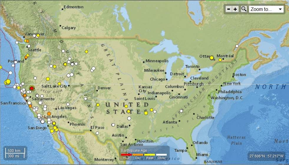
Seismic Activity Last 30 days
….
Arkansas
3.4 16km N of Morrilton, Arkansas 2013-05-24 00:44:24-05:00 5.7 km deep
2.5 15km NNE of Morrilton, Arkansas 2013-05-23 07:22:16-05:00 5.5 km deep
2.5 15km NNE of Morrilton, Arkansas 2013-05-22 17:02:44-05:00 5.1 km deep
3.4 16km N of Morrilton, Arkansas 2013-05-22 12:19:39-05:00 5.5 km deep
2.9 22km E of Cave City, Arkansas 2013-05-21 04:28:06-05:00 15.5 km deep
….
California
3.3 18km SW of Fort Irwin, California 2013-05-25 20:58:31-05:00 3.0 km deep
2.7 1km NNW of The Geysers, California 2013-05-25 19:29:01-05:00 2.2 km deep
3.5 10km WNW of Greenville, California 2013-05-25 17:27:39-05:00 0.0 km deep
3.5 9km WNW of Greenville, California 2013-05-25 13:43:02-05:00 0.0 km deep
2.9 9km WNW of Greenville, California 2013-05-25 12:35:12-05:00 0.0 km deep
2.6 12km WNW of Greenville, California 2013-05-25 10:04:09-05:00 0.1 km deep
2.6 8km WNW of Greenville, California 2013-05-25 09:48:10-05:00 0.0 km deep
2.7 10km SSE of San Juan Bautista, California 2013-05-25 05:12:59-05:00 10.4 km deep
3.3 10km WNW of Greenville, California 2013-05-24 21:27:04-05:00 0.1 km deep
3.0 9km WNW of Greenville, California 2013-05-24 21:23:44-05:00 0.0 km deep
2.5 11km WNW of Greenville, California 2013-05-24 21:18:05-05:00 1.3 km deep
2.7 9km WNW of Greenville, California 2013-05-24 18:29:07-05:00 0.0 km deep
2.6 11km SW of Westwood, California 2013-05-24 18:27:35-05:00 1.3 km deep
2.7 9km WNW of Greenville, California 2013-05-24 16:32:58-05:00 0.1 km deep
3.0 19km NE of Shawville, Canada 2013-05-24 14:48:08-05:00 18.0 km deep
3.2 12km WNW of Greenville, California 2013-05-24 13:58:14-05:00 0.0 km deep
3.2 13km WNW of Greenville, California 2013-05-24 13:48:31-05:00 0.1 km deep
2.8 7km WNW of Greenville, California 2013-05-24 13:43:19-05:00 0.0 km deep
2.9 10km WNW of Greenville, California 2013-05-24 13:22:06-05:00 0.0 km deep
2.6 9km WNW of Greenville, California 2013-05-24 13:16:58-05:00 0.0 km deep
2.8 8km WNW of Greenville, California 2013-05-24 12:36:46-05:00 0.0 km deep
2.5 7km NW of Greenville, California 2013-05-24 11:29:53-05:00 0.0 km deep
2.6 8km WNW of Greenville, California 2013-05-24 11:29:10-05:00 0.0 km deep
3.9 9km WNW of Greenville, California 2013-05-24 10:26:21-05:00 9.8 km deep
2.9 8km WNW of Greenville, California 2013-05-24 08:18:54-05:00 6.3 km deep
2.5 10km WNW of Greenville, California 2013-05-24 07:36:14-05:00 1.0 km deep
2.8 10km WNW of Greenville, California 2013-05-24 06:59:08-05:00 0.0 km deep
3.8 9km WNW of Greenville, California 2013-05-24 06:40:15-05:00 0.0 km deep
2.9 10km WNW of Greenville, California 2013-05-24 06:21:38-05:00 0.0 km deep
2.8 10km WNW of Greenville, California 2013-05-24 06:12:41-05:00 0.1 km deep
3.6 11km WNW of Greenville, California 2013-05-24 04:52:18-05:00 0.0 km deep
4.0 10km WNW of Greenville, California 2013-05-24 04:42:52-05:00 5.9 km deep
3.1 8km WNW of Greenville, California 2013-05-24 03:23:14-05:00 0.0 km deep
2.7 12km WNW of Greenville, California 2013-05-24 03:15:17-05:00 6.5 km deep
4.9 11km WNW of Greenville, California 2013-05-24 03:02:19-05:00 5.2 km deep
3.7 14km SW of Westwood, California 2013-05-24 02:46:08-05:00 0.0 km deep
2.6 9km WNW of Greenville, California 2013-05-24 02:38:43-05:00 7.6 km deep
2.5 11km WNW of Greenville, California 2013-05-24 02:22:19-05:00 2.8 km deep
2.7 10km WNW of Greenville, California 2013-05-24 02:20:21-05:00 6.2 km deep
2.5 13km WNW of Greenville, California 2013-05-24 02:19:20-05:00 7.3 km deep
3.0 12km WNW of Greenville, California 2013-05-24 02:10:03-05:00 0.0 km deep
2.6 12km WNW of Greenville, California 2013-05-24 02:04:14-05:00 0.0 km deep
2.7 10km WNW of Greenville, California 2013-05-24 01:58:51-05:00 0.1 km deep
3.4 13km SSW of Westwood, California 2013-05-24 01:44:58-05:00 0.0 km deep
2.8 12km WNW of Greenville, California 2013-05-24 01:37:28-05:00 0.0 km deep
3.0 10km NW of Greenville, California 2013-05-24 01:31:06-05:00 0.0 km deep
2.7 8km NW of Greenville, California 2013-05-24 01:12:52-05:00 3.4 km deep
3.0 8km WNW of Greenville, California 2013-05-24 00:46:56-05:00 0.0 km deep
2.9 8km WNW of Greenville, California 2013-05-24 00:39:43-05:00 0.0 km deep
3.1 13km SSW of Westwood, California 2013-05-24 00:24:42-05:00 0.0 km deep
2.9 9km NW of Greenville, California 2013-05-24 00:18:23-05:00 0.0 km deep
2.7 7km WNW of Greenville, California 2013-05-24 00:13:46-05:00 2.5 km deep
2.9 9km WNW of Greenville, California 2013-05-24 00:09:13-05:00 0.1 km deep
2.7 11km WNW of Greenville, California 2013-05-24 00:06:15-05:00 0.2 km deep
3.6 8km WNW of Greenville, California 2013-05-24 00:01:55-05:00 0.0 km deep
3.5 9km WNW of Greenville, California 2013-05-23 23:58:57-05:00 0.1 km deep
3.4 10km WNW of Greenville, California 2013-05-23 23:58:08-05:00 0.0 km deep
2.8 10km NW of Greenville, California 2013-05-23 23:44:42-05:00 0.1 km deep
2.7 10km WNW of Greenville, California 2013-05-23 23:40:30-05:00 0.0 km deep
2.7 10km WNW of Greenville, California 2013-05-23 23:29:42-05:00 0.0 km deep
2.5 9km WNW of Greenville, California 2013-05-23 23:28:31-05:00 1.3 km deep
2.5 10km WNW of Greenville, California 2013-05-23 23:25:19-05:00 0.1 km deep
2.6 10km NW of Greenville, California 2013-05-23 23:23:40-05:00 5.1 km deep
2.8 10km NW of Greenville, California 2013-05-23 23:09:15-05:00 1.3 km deep
3.4 15km SE of Chester, California 2013-05-23 23:08:21-05:00 0.0 km deep
2.6 12km SSW of Westwood, California 2013-05-23 23:07:44-05:00 1.6 km deep
2.6 10km WNW of Greenville, California 2013-05-23 23:04:09-05:00 1.6 km deep
3.4 9km WNW of Greenville, California 2013-05-23 22:55:56-05:00 10.3 km deep
3.4 10km WNW of Greenville, California 2013-05-23 22:55:31-05:00 6.1 km deep
3.3 11km NW of Greenville, California 2013-05-23 22:51:20-05:00 11.2 km deep
4.2 9km WNW of Greenville, California 2013-05-23 22:50:28-05:00 11.4 km deep
4.6 10km WNW of Greenville, California 2013-05-23 22:48:57-05:00 14.0 km deep
5.7 11km WNW of Greenville, California 2013-05-23 22:47:08-05:00 11.0 km deep
2.7 33km SW of Rio Dell, California 2013-05-22 16:26:44-05:00 22.6 km deep
4.2 238km W of Crescent City, California 2013-05-20 08:56:30-05:00 10.0 km deep
4.3 250km W of Crescent City, California 2013-05-20 08:23:44-05:00 10.0 km deep
4.3 273km W of Crescent City, California 2013-05-20 08:20:53-05:00 10.0 km deep
4.1 248km W of Crescent City, California 2013-05-20 08:19:30-05:00 10.0 km deep
2.8 4km SW of Niland, California 2013-05-19 10:44:43-05:00 2.1 km deep
4.0 10km S of Rancho Palos Verdes, California 2013-05-15 15:00:06-05:00 1.2 km deep
4.0 10km S of Rancho Palos Verdes, California 2013-05-15 15:00:06-05:00 0.1 km deep
3.1 7km NNE of Cabazon, California 2013-05-15 11:20:05-05:00 17.9 km deep
3.0 6km NW of The Geysers, California 2013-05-15 01:11:55-05:00 4.0 km deep
….
Idaho
2.7 53km NE of Idaho City, Idaho 2013-05-21 01:23:52-05:00 9.0 km deep
2.7 53km NE of Idaho City, Idaho 2013-05-21 01:23:52-05:00 9.0 km deep
….
Montana
2.9 12km SW of Lima, Montana 2013-05-22 04:32:24-05:00 11.6 km deep
2.8 57km NNW of Hysham, Montana 2013-05-21 09:54:34-05:00 7.2 km deep
2.6 13km SW of Lima, Montana 2013-05-21 08:13:55-05:00 10.5 km deep
3.2 12km SW of Lima, Montana 2013-05-21 06:20:36-05:00 11.1 km deep
2.7 13km WSW of Lima, Montana 2013-05-21 05:01:00-05:00 10.5 km deep
3.3 13km SW of Lima, Montana 2013-05-21 03:34:18-05:00 9.7 km deep
2.6 13km WSW of Lima, Montana 2013-05-23 12:30:14-05:00 3.7 km deep
2.8 29km SSE of Seeley Lake, Montana 2013-05-17 06:44:15-05:00 11.6 km deep
2.7 34km SSW of Three Forks, Montana
….
Nevada
3.3 55km E of McDermitt, Nevada 2013-05-23 15:56:31-05:00 0.0 km deep
2.7 35km NNW of West Wendover, Nevada 2013-05-20 17:50:25-05:00 0.0 km deep
….
Oklahoma
2.7 18km SSE of Medford, Oklahoma 2013-05-19 08:33:06-05:00 6.8 km dee
2.9 11km ENE of Luther, Oklahoma 2013-05-19 20:46:35-05:00 4.5 km deep
2.6 6km N of Harrah, Oklahoma 2013-05-15 05:54:06-05:00 4.3 km deep
….
Oregon
3.9 Off the coast of Oregon 2013-05-21 15:28:31-05:00 12.3 km deep
4.3 252km WSW of Brookings, Oregon 2013-05-20 08:12:44-05:00 10.0 km deep
4.4 234km WSW of Brookings, Oregon 2013-05-20 09:07:59-05:00 10.0 km deep
….
Washington State
2.5 3km ENE of Lewisville, Washington 2013-05-25 11:40:51-05:00 1.8 km deep
2.9 8km NE of Sedro-Woolley, Washington 2013-05-25 10:22:59-05:00 8.2 km deep
2.5 11km N of Anacortes, Washington 2013-05-22 08:48:06-05:00 15.5 km deep
2.5 32km NE of Amboy, Washington 2013-05-21 03:03:05-05:00 6.0 km deep
….
Wyoming
3.6 23km WNW of Afton, Wyoming 2013-05-16 00:23:52-05:00 4.8 km deep
….
Related articles
- CA earthquake today 2013 (disaster-report.com)
- EQ’s and 22 Aftershocks shake up northern California (21stcenturyscreenshots.wordpress.com)
- Earthquake Rattles Homes And Nerves In California (kmvt.com)
- Earthquake Shakes up Northern California Town (guardianlv.com)
- Alaska – 5 Earthquakes , 3.0 to 2.6 Magnitude May 18th, 2013 : Total of 149 EQ’s in the last 31 days (familysurvivalprotocol.com)
- 5.7-magnitude earthquake in northern California last night (earthsky.org)
- California – 10 Earthquakes Ranging Between 2.5 and 3.0 Registered April 29th,2013 (familysurvivalprotocol.com)
The Watchers
Chillymanjaro on May 26, 2013 June 1 marks the beginning of Atlantic hurricane season. On May 23, 2013 NOAA’s Climate Prediction Center released its 2013 Atlantic Hurricane Season Forecast, predicting an active season. NOAA classifies 12 of the 18 seasons since 1995 as above normal, with eight being very active.
NOAA predicts (with 70% like hood) 13 to 20 named storms total, between 7 and 11 of which will be hurricanes, with 3 to 6 major hurricanes. An average for Atlantic hurricane season is 12 named storms, 6 hurricanes and 3 major hurricanes, so we can say NOAA calls for an above-average active season. NHC points that this year’s season may unleash stronger storms than in the last couple of years.
After Hurricane Sandy experience, NOAA warns that tropical storm and hurricane impacts are not limited only to the coastline, but strong winds, torrential rain, flooding and tornadoes often threaten further inland areas.

This map shows the tracks of all Atlantic hurricanes which formed between 1851 and 2005. The points show the locations of the storms at six-hourly intervals and use the color scheme shown to the right from Saffir-Simpson Hurricane Scale. (Credit: NOAA/NHC)
Oceanic and atmospheric conditions in the Atlantic basin are expected to produce more and stronger hurricanes. Three climate factors that A continuation of the atmospheric climate pattern, which includes a strong west African monsoon (responsible for the ongoing era of high activity for Atlantic hurricanes), warmer-than-average water temperatures in the tropical Atlantic Ocean and Caribbean Sea and weak El Niño phenomena will strongly influence Atlantic hurricane activity.
This year’s season will be tracked with improved to forecast models, data gathering and the National Hurricane Center communication procedure for post-tropical cyclones. From July, a new supercomputer will run an upgraded Hurricane Weather Research and Forecasting (HWRF) model that provides significantly enhanced depiction of storm structure and improved storm intensity forecast guidance. NOAA’s Hurricane Hunter aircraft will use new Doppler radar data transmitted in real-time This will help forecasters better analyze rapidly evolving storm conditions, and these data could further improve the HWRF model forecasts by 10 to 15 %.

Hurricane Sandy as seen from NOAA’s GOES-13 satellite on October 28, 2012.(Credit:NOAA/NASA)
Related articles
- NOAA predicts active 2013 Atlantic hurricane season (noaanews.noaa.gov)
- Active or ‘extremely active’ Atlantic hurricane season predicted for 2013 (sciencedaily.com)
- NOAA predicts active or extremely active” 2013 Atlantic hurricane season (antiguaobserver.com)
- NOAA predicts above-normal Atlantic hurricane season (cnn.com)
- NOAA Predicting Possibly “Extremely Active Hurricane Season” (miami.cbslocal.com)
- NOAA predicts an active 2013 Atlantic hurricane season (wtvr.com)
- NOAA predicts above-normal Atlantic hurricane season (wqad.com)
- NOAA expects an active 2013 Atlantic hurricane season (earthsky.org)
http://news.yahoo.com/3-feet-snow-upstate-ny-memorial-weekend-025106821.html?.tsrc=rogers
by kauilapele

Poofness 5-26-13..."The Continuing"
Greetings and Salutations;
So, it's the end already, the work is done and it's all over but the shouting! That's what you said last week now what in heaven's name is the hold up. NOTHING! Let's just cut the crap and let me splain things to you if your man enough to take it. IT AINT NEVER BEEN DONE BEFORE! Now there that's as crystal clear as if Mark Twain himself had said it. Besides I said “it's close enough to smell.” The hard cold fact is nothing is wrong and everything is rolling smoothly as this mechanical process is working pedal to the metal but some documents handed down through the generations need to be handled carefully which slows things a bit. Also, returning the “Republic” to it's glory days is a very delicate process needs to be massaged into place. We are on a week to week schedule for final completion. Like preparing a gourmet meal the process at times is meticulous but oh is the wait so worth it. “A Promise is a Promise” the masses are next and very, very soon!
While your waiting a minute reflect on these words........How can you call yourself a christian and not follow what the master said about taking care of the 'least'. There are principles of nature that even effect govs, greed will get you in the end. The st germain trust exists because it's intention was always to shift the wealth of the world from the greedy to those in need and make life's principles real for the common folk. Nature will always make a balance and no amount of politics can change that. They joined withe the dragons because their purpose was the same. The elders joined them both for the same reason. They could see the eddies of time moving to the big shift and they have 'age' on most. They broke the code on longevity and have lived accordingly ever since. The secret is 'attitude adjustment'. Change your mind, change your life. Take ownership of your own crap. Man, it is time to end serfdom for the masses. The lords are being whupped big time, from the top and not a thing they can do about it, they borrowed and failed to pay back, the casino has been foreclosed upon.
The skies have been rumbling and the weather forecasts rain on all the crops. A harvest for the world, as it were is close at hand. Reagan's appointee will finally be able to take a much needed vacation from his labors and I can go sit my butt on a nice beach and drink umbrella drinks...and never speak of this change over again.
Thank you all for the prayers for my continuance. My job keeps going. I celebrate your ability to hold your ground and a promise, made so long ago. That day of arrival is shortly and like a lightning bolt on a clear day.
As we were going to press with this newsletter our hearts were saddened as we learned of Poof's passing. After a very brief illness “Poof” has gone to be with his MASTER. Thank you, to all of our loyal readers for your prayers and support at such a very sad time for us all. Poof can now finally see clearly the “Big Picture” that he has worked so hard for all of these years! He will forever guide our thoughts and deeds as we seek out our future in the “bright new world” that awaits us. With love and graditude for all you have done for us all through the years be assured that we will always remember you!
Courage, brother! Do not stumble,
Though thy path be dark as night;
There's a star to guide the humble,
Trust in God and do the right.
….............Norman MacLeod
Please be assured the office of Poof ness, under the direction of Susan his longtime assistant, will continue Poof's work as we publish the weekly newsletter to keep you all in formed until that final moment. Please accept our thanks in advance, as many of you may wish to email your condolences. Our email box is so backed up that we may not be able to give each of you a personal reply. Consultations still available until our doorbell rings.
Love and Kisses,
Susan
From the office of Poofness
New study reveals how glyphosate in Monsanto’s Roundup inhibits natural detoxification in human cells
Friday, May 24, 2013 by: Lance Devon

(NaturalNews) The modern age of industrial agriculture and manufacturing has dumped heavy metals, carninogens, plastics, and pesticides into the environment at alarming rates. These toxins are showing up in most human tissue cells today. One distinct chemical may be trapping these toxins in human cells, limiting the human body’s ability to detoxify its own cells. In a new peer reviewed study, this sinister chemical, glyphosate, has been proven to inhibit the human cell’s ability to detoxify altogether. Glyphosate, found in Monsanto’s Roundup, is being deemed by publishers of the new study “one of the most dangerous chemicals” being unleashed into the environment today.
Download the PDF of the study here: http://www.mdpi.com/1099-4300/15/4/1416
How glyphosate destroys human cells
Glyphosate, most commonly found in conventional sugar, corn, soy and wheat products, throws off the cytochrome P450 gene pathway, inhibiting enzyme production in the body. CYP enzymes play a crucial role in detoxifying xenobiotics, which include drugs, carcinogens, and pesticides. By inhibiting this natural detoxification process, glyphosate systematically enhances the damaging effects of other environmental toxins that get in the body. This, in turn, disrupts homeostasis, increases inflammation, and leads to a slow deconstruction of the cellular system. Toxins build up in the gut over time and break down through the intestinal walls, infiltrating blood, and ultimately passing through the brain/blood barrier, damaging neurological function.
Important CYP enzymes that are affected include aromatase, the enzyme that converts androgen into estrogen, 21-Hydroxylase, which creates stress hormone cortisol, and aldosterone, which regulates blood pressure.
Getting to the gut
Even as evidence mounts, Monsanto asserts that glyphosate is not harmful to humans, citing that its mechanism of action in plants (the disruption of the shikimate pathway), is not present in humans. This is not true.
The shikimate pathway, which is involved in the synthesis of the essential aromatic amino acids phenylalanine, tyrosine, and tryptophan, is present in human gut bacteria, which has a direct relationship with the human body, aiding in digestion, synthesizing vitamins, detoxifying carcinogens, and participating in immune system function.
By inhibiting the body’s gut flora from performing its essential function in the human body, glyphosate heightens many health issues facing the Western world today.
These conditions include inflammatory bowel diseases, Crohn’s disease, obesity, and even dementia and depression. Also, by restricting gut bacteria from absorbing nutrients, glyphosate voids the body of essential life-giving vitamins.
Depletion of serum tryptophan and its link to obesity
Glysophate’s damaging effects on gut bacteria lead to depleted sulfate supplies in the gut, resulting in inflammatory bowel disease. As more chemicals are absorbed from the environment, alterations in body chemistry actively promote weight gain by blocking nutrient absorption. By effecting CYP enzymes in the liver, obesity incidence is compounded, impairing the body’s ability to detoxify synthetics chemicals. Since serotonin is derived from tryptophan and acts an appetite suppressant, the depletion of tryptophan encourages overeating in the brain, leading to obesity.
In need of urgent, massive awakening
Authors of the new review point out that “glyphosate is likely to be pervasive in our food supply and may be the most biologically disruptive chemical in our environment.” Monsanto is already lashing back at these claims, calling this peer reviewed study, “bad science” and “another bogus study.” What Monsanto fails to is mention that most of the studies on glyphosate’s “safety” are conducted by Monsanto themselves, which is bias to the core.
The authors of this new study instead call out for more independent research to be done to validate their findings. They are concerned with glyphosate’s inhibition of the cytochrome P450 (CYP) enzymes in the body, which are hindering the body’s natural detoxification ability.
There is certainly a need for more empowering education on chemicals like glyphosate. There needs to be a kind of public mass awakening that correlates Monsanto’s Roundup with skull and crossbones. If anything, Americans have the right to know how their food was produced, engineered, and poisoned, and everyone should pitch in and stop using toxic glyphosate-laced Roundup at all costs.
Sources for this article include:
http://www.mdpi.com/1099-4300/15/4/1416
http://www.foodandwaterwatch.org
Related articles
- New study reveals how glyphosate in Monsanto’s Roundup inhibits natural detoxification in human cells (dprogram.net)
- Study Reveals How Glyphosate in Roundup Inhibits Natural Detoxification (ultimatefulfillment.org)
- New study reveals how glyphosate in Monsanto’s Roundup inhibits natural detoxification in human cells (hangthebankers.com)
- New study reveals how glyphosate in Monsanto’s Roundup inhibits natural detoxification in human cells (wikkorg.wordpress.com)
- Monsanto’s Roundup inhibits natural detoxification in human cells (lunaticoutpost.com)
- Study Links Monsanto’s Roundup to Autism, Parkinson’s and Alzheimer’s (nationofchange.org)
- Gut punch: Monsanto could be destroying your microbiome (grist.org)
- Anthony Samsel and Stephanie Seneff – Glyphosate’s Suppression of Cytochrome P450 Enzymes and Amino Acid Biosynthesis by the Gut Microbiome: Pathways to Modern Diseases (prn.fm)
- New Study Links Monsanto’s Roundup To Autism, Parkinson’s and Alzheimer’s (collective-evolution.com)
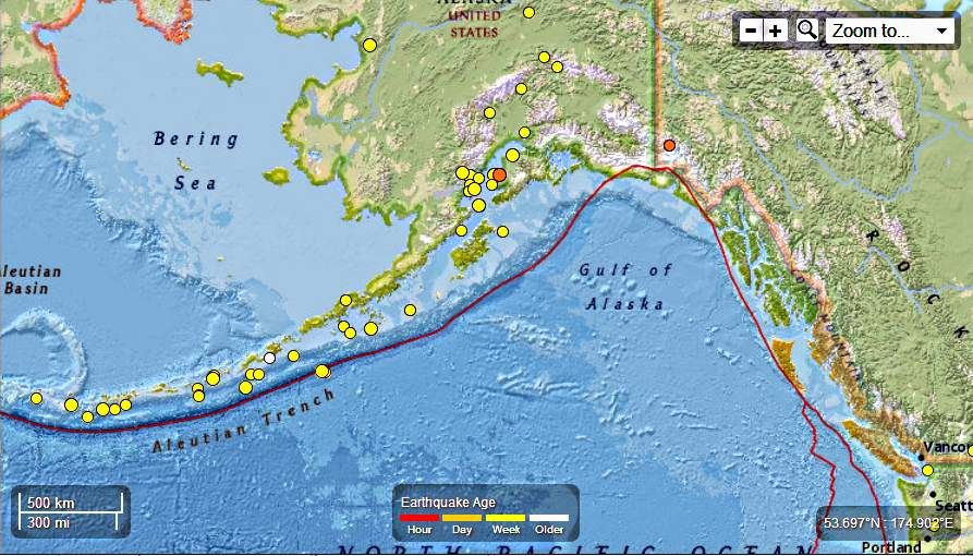
Alaska – 16 Earthquakes , 3.8 to 3.0 Magnitude May 21st – 24th, 2013 : Total of 165 EQ’s in the last 37 days
Earth Watch Report - Earthquakes
….
Not counted in the total used for this report are any quakes under 3.0 There were a total of 26 EQs 2.9 and lower from May 19th to May 24th. For a total of 42 EQ’s in the last 5 days and a grand total of 191 EQs in 37 days
Seismic Activity in the last 7 days
Seismic Activity in the last 30 days
….
M3.3 – 11km S of Yunaska Island, Alaska
2013-05-21 08:56:12 UTC

Event Time
- 2013-05-21 08:56:12 UTC
- 2013-05-20 23:56:12 UTC-09:00 at epicenter
- 2013-05-21 03:56:12 UTC-05:00 system time
Location
52.532°N 170.676°W depth=74.2km (46.1mi)
Nearby Cities
- 11km (7mi) S of Yunaska Island, Alaska
- 1519km (944mi) SSE of Anadyr’, Russia
- 1582km (983mi) WSW of Anchorage, Alaska
- 1611km (1001mi) WSW of Knik-Fairview, Alaska
- 2332km (1449mi) W of Whitehorse, Canada
….
M3.0 – 67km S of Tanaga Volcano, Alaska
2013-05-21 10:27:31 UTC

Event Time
- 2013-05-21 10:27:31 UTC
- 2013-05-20 22:27:31 UTC-12:00 at epicenter
- 2013-05-21 05:27:31 UTC-05:00 system time
Location
51.277°N 178.098°W depth=14.7km (9.1mi)
Nearby Cities
- 67km (42mi) S of Tanaga Volcano, Alaska
- 1522km (946mi) SSE of Anadyr’, Russia
- 1596km (992mi) E of Petropavlovsk-Kamchatskiy, Russia
- 1613km (1002mi) E of Yelizovo, Russia
- 2821km (1753mi) W of Whitehorse, Canada
….
M3.8 – 42km SW of Chernabura Island, Alaska
2013-05-21 15:59:08 UTC

Event Time
- 2013-05-21 15:59:08 UTC
- 2013-05-21 04:59:08 UTC-11:00 at epicenter
- 2013-05-21 10:59:08 UTC-05:00 system time
Location
54.547°N 160.077°W depth=32.9km (20.4mi)
Nearby Cities
- 42km (26mi) SW of Chernabura Island, Alaska
- 955km (593mi) SW of Anchorage, Alaska
- 990km (615mi) SW of Knik-Fairview, Alaska
- 1335km (830mi) SW of Fairbanks, Alaska
- 1626km (1010mi) W of Juneau, Alaska
….
M3.3 – 11km S of Yunaska Island, Alaska
2013-05-21 08:56:12 UTC
Event Time
- 2013-05-21 08:56:12 UTC
- 2013-05-20 23:56:12 UTC-09:00 at epicenter
- 2013-05-21 03:56:12 UTC-05:00 system time
Location
52.532°N 170.676°W depth=74.2km (46.1mi)
Nearby Cities
- 11km (7mi) S of Yunaska Island, Alaska
- 1519km (944mi) SSE of Anadyr’, Russia
- 1582km (983mi) WSW of Anchorage, Alaska
- 1611km (1001mi) WSW of Knik-Fairview, Alaska
- 2332km (1449mi) W of Whitehorse, Canada
….
M3.0 – 67km S of Tanaga Volcano, Alaska
2013-05-21 10:27:31 UTC
Event Time
- 2013-05-21 10:27:31 UTC
- 2013-05-20 22:27:31 UTC-12:00 at epicenter
- 2013-05-21 05:27:31 UTC-05:00 system time
Location
51.277°N 178.098°W depth=14.7km (9.1mi)
Nearby Cities
- 67km (42mi) S of Tanaga Volcano, Alaska
- 1522km (946mi) SSE of Anadyr’, Russia
- 1596km (992mi) E of Petropavlovsk-Kamchatskiy, Russia
- 1613km (1002mi) E of Yelizovo, Russia
- 2821km (1753mi) W of Whitehorse, Canada
….
M3.8 – 42km SW of Chernabura Island, Alaska
2013-05-21 15:59:08 UTC
Event Time
- 2013-05-21 15:59:08 UTC
- 2013-05-21 04:59:08 UTC-11:00 at epicenter
- 2013-05-21 10:59:08 UTC-05:00 system time
Location
54.547°N 160.077°W depth=32.9km (20.4mi)
Nearby Cities
- 42km (26mi) SW of Chernabura Island, Alaska
- 955km (593mi) SW of Anchorage, Alaska
- 990km (615mi) SW of Knik-Fairview, Alaska
- 1335km (830mi) SW of Fairbanks, Alaska
- 1626km (1010mi) W of Juneau, Alaska
….
M3.0 – 35km N of Anchor Point, Alaska
2013-05-22 01:06:20 UTC

Event Time
- 2013-05-22 01:06:20 UTC
- 2013-05-21 17:06:20 UTC-08:00 at epicenter
- 2013-05-21 20:06:20 UTC-05:00 system time
Location
60.093°N 151.776°W depth=56.1km (34.9mi)
Nearby Cities
- 35km (22mi) N of Anchor Point, Alaska
- 161km (100mi) SW of Anchorage, Alaska
- 197km (122mi) SW of Knik-Fairview, Alaska
- 568km (353mi) SSW of Fairbanks, Alaska
- 921km (572mi) W of Whitehorse, Canada
….
M3.2 – 59km SSE of Semisopochnoi Island, Alaska
2013-05-22 10:02:47 UTC

Event Time
- 2013-05-22 10:02:47 UTC
- 2013-05-22 22:02:47 UTC+12:00 at epicenter
- 2013-05-22 05:02:47 UTC-05:00 system time
Location
51.431°N 179.826°E depth=69.0km (42.9mi)
Nearby Cities
- 59km (37mi) SSE of Semisopochnoi Island, Alaska
- 1452km (902mi) E of Petropavlovsk-Kamchatskiy, Russia
- 1469km (913mi) E of Vilyuchinsk, Russia
- 1470km (913mi) E of Yelizovo, Russia
- 2924km (1817mi) W of Whitehorse, Canada
….
M3.0 – 27km NNE of Sterling, Alaska
2013-05-22 16:26:11 UTC
Event Time
- 2013-05-22 16:26:11 UTC
- 2013-05-22 08:26:11 UTC-08:00 at epicenter
- 2013-05-22 11:26:11 UTC-05:00 system time
Location
60.766°N 150.576°W depth=52.5km (32.6mi)
Nearby Cities
- 27km (17mi) NNE of Sterling, Alaska
- 62km (39mi) SW of Anchorage, Alaska
- 98km (61mi) SSW of Knik-Fairview, Alaska
- 475km (295mi) SSW of Badger, Alaska
- 844km (524mi) W of Whitehorse, Canada
…
M3.1 – 72km WSW of Redoubt Volcano, Alaska
2013-05-23 05:58:36 UTC

Event Time
- 2013-05-23 05:58:36 UTC
- 2013-05-22 21:58:36 UTC-08:00 at epicenter
- 2013-05-23 00:58:36 UTC-05:00 system time
Location
60.182°N 153.912°W depth=199.8km (124.1mi)
Nearby Cities
- 72km (45mi) WSW of Redoubt Volcano, Alaska
- 247km (153mi) WSW of Anchorage, Alaska
- 277km (172mi) WSW of Knik-Fairview, Alaska
- 608km (378mi) SW of Fairbanks, Alaska
- 1036km (644mi) W of Whitehorse, Canada
….
M3.1 – 86km SSE of Nikolski, Alaska
2013-05-23 19:08:50 UTC

Event Time
- 2013-05-23 19:08:50 UTC
- 2013-05-23 08:08:50 UTC-11:00 at epicenter
- 2013-05-23 14:08:50 UTC-05:00 system time
Location
52.193°N 168.485°W depth=11.0km (6.8mi)
Nearby Cities
- 86km (53mi) SSE of Nikolski, Alaska
- 1508km (937mi) WSW of Anchorage, Alaska
- 1540km (957mi) SW of Knik-Fairview, Alaska
- 1612km (1002mi) SE of Anadyr’, Russia
- 2237km (1390mi) W of Whitehorse, Canada
….
M3.5 – 75km WSW of Anchor Point, Alaska
2013-05-23 20:31:31 UTC
Event Time
- 2013-05-23 20:31:31 UTC
- 2013-05-23 12:31:31 UTC-08:00 at epicenter
- 2013-05-23 15:31:31 UTC-05:00 system time
Location
59.610°N 153.131°W depth=102.1km (63.4mi)
Nearby Cities
- 75km (47mi) WSW of Anchor Point, Alaska
- 252km (157mi) SW of Anchorage, Alaska
- 287km (178mi) SW of Knik-Fairview, Alaska
- 646km (401mi) SSW of Fairbanks, Alaska
- 1008km (626mi) W of Whitehorse, Canada
….
M3.1 – 212km SE of Akutan, Alaska
2013-05-24 04:36:38 UTC

Event Time
- 2013-05-24 04:36:38 UTC
- 2013-05-23 17:36:38 UTC-11:00 at epicenter
- 2013-05-23 23:36:38 UTC-05:00 system time
Location
52.850°N 163.410°W depth=33.1km (20.6mi)
Nearby Cities
- 212km (132mi) SE of Akutan, Alaska
- 1236km (768mi) SW of Anchorage, Alaska
- 1270km (789mi) SW of Knik-Fairview, Alaska
- 1602km (995mi) SW of College, Alaska
- 1909km (1186mi) W of Juneau, Alaska
….
M3.0 – 28km SSW of Cohoe, Alaska
2013-05-25 04:04:34 UTC
Event Time
- 2013-05-25 04:04:34 UTC
- 2013-05-24 20:04:34 UTC-08:00 at epicenter
- 2013-05-24 23:04:34 UTC-05:00 system time
Location
60.121°N 151.419°W depth=57.6km (35.8mi)
Nearby Cities
- 28km (17mi) SSW of Cohoe, Alaska
- 147km (91mi) SW of Anchorage, Alaska
- 183km (114mi) SSW of Knik-Fairview, Alaska
- 558km (347mi) SSW of Badger, Alaska
- 901km (560mi) W of Whitehorse, Canada
….
Related articles
- Alaska – 16 Earthquakes , 4.3 to 2.5 Magnitude May 15th – 16th – 17th, 2013 : Total of 142 EQ’s in the last 30 days (familysurvivalprotocol.com)
- Alaska – 8 EQ’s ranging from 3.2 to2.6 magnitude April 30th, 2013 : Total of 83 Earthquakes in the last 17 days (familysurvivalprotocol.com)
- Alaska – 7 Earthquakes , 3.3 to 2.5 Magnitude May 18th, 2013 : Total of 149 EQ’s in the last 31 days (familysurvivalprotocol.com)
- Alaska – 5 Earthquakes , 3.0 to 2.6 Magnitude May 18th, 2013 : Total of 149 EQ’s in the last 31 days (familysurvivalprotocol.com)
- Alaska – 5 Earthquakes , 4.5 to 2.6 Magnitude May 14th, 2013 : Total of 126 EQ’s in the last 27 days (familysurvivalprotocol.com)
- Alaska – 16 Earthquakes Ranging from 4.5 to 2.5 Magnitude in the last 3 days May 7th – 9th, 2013 : Total of 119 EQ’s in the last 25 days (familysurvivalprotocol.com)
- Alaska – 6 Earthquakes Ranging From 3.2 to 2.5 Magnitude : Total of 89 EQ’s in the last 18 days (familysurvivalprotocol.com)
- Alaska – 6 Earthquakes Ranging From 4.5 to 2.5 Magnitude May 2nd, 2013 : Total of 95 EQ’s in the last 19 days (familysurvivalprotocol.com)
- Alaska – 2 Earthquakes , 4.8 to 4.2 Magnitude May 10th, 2013 : Total of 121 EQ’s in the last 26 days (familysurvivalprotocol.com)
- Alaska – Nineteen Earthquakes Ranging From 5.1 to 2.5 Magnitude April 22nd and 23rd , 2013. A Total of 75 EQ’s in the last 10 days (familysurvivalprotocol.com)
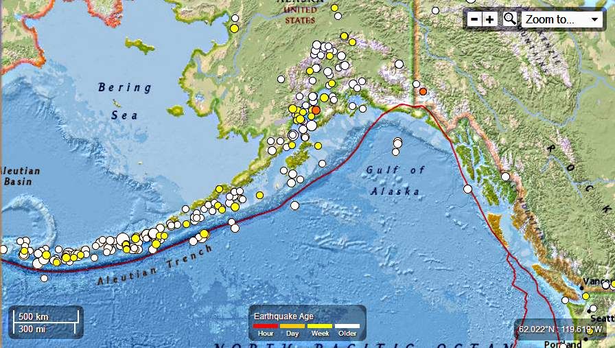
Earth Watch Report - Earthquakes
….
M4.8 – 117km SE of Petropavlovsk-Kamchatskiy, Russia
2013-05-20 00:05:07 UTC

Event Time
- 2013-05-20 00:05:07 UTC
- 2013-05-20 11:05:07 UTC+11:00 at epicenter
- 2013-05-19 19:05:07 UTC-05:00 system time
Location
52.418°N 160.048°E depth=60.1km (37.3mi)
Nearby Cities
- 117km (73mi) SE of Petropavlovsk-Kamchatskiy, Russia
- 125km (78mi) ESE of Vilyuchinsk, Russia
- 141km (88mi) SE of Yelizovo, Russia
- 981km (610mi) SE of Magadan, Russia
- 2455km (1525mi) NE of Tokyo, Japan
….
M5.3 – 131km SE of Petropavlovsk-Kamchatskiy, Russia
2013-05-20 00:13:17 UTC
Event Time
- 2013-05-20 00:13:17 UTC
- 2013-05-20 11:13:17 UTC+11:00 at epicenter
- 2013-05-19 19:13:17 UTC-05:00 system time
Location
52.305°N 160.170°E depth=33.2km (20.6mi)
Nearby Cities
- 131km (81mi) SE of Petropavlovsk-Kamchatskiy, Russia
- 138km (86mi) ESE of Vilyuchinsk, Russia
- 155km (96mi) SE of Yelizovo, Russia
- 996km (619mi) SE of Magadan, Russia
- 2453km (1524mi) NE of Tokyo, Japan
….
M4.9 – 124km ESE of Petropavlovsk-Kamchatskiy, Russia
2013-05-20 00:22:13 UTC
Event Time
- 2013-05-20 00:22:13 UTC
- 2013-05-20 11:22:13 UTC+11:00 at epicenter
- 2013-05-19 19:22:13 UTC-05:00 system time
Location
52.432°N 160.183°E depth=30.2km (18.7mi)
Nearby Cities
- 124km (77mi) ESE of Petropavlovsk-Kamchatskiy, Russia
- 132km (82mi) ESE of Vilyuchinsk, Russia
- 147km (91mi) SE of Yelizovo, Russia
- 984km (611mi) SE of Magadan, Russia
- 2463km (1530mi) NE of Tokyo, Japan
….
M5.1 – 121km SE of Petropavlovsk-Kamchatskiy, Russia
2013-05-20 01:07:39 UTC
Event Time
- 2013-05-20 01:07:39 UTC
- 2013-05-20 12:07:39 UTC+11:00 at epicenter
- 2013-05-19 20:07:39 UTC-05:00 system time
Location
52.415°N 160.119°E depth=42.6km (26.5mi)
Nearby Cities
- 121km (75mi) SE of Petropavlovsk-Kamchatskiy, Russia
- 129km (80mi) ESE of Vilyuchinsk, Russia
- 145km (90mi) SE of Yelizovo, Russia
- 984km (611mi) SE of Magadan, Russia
- 2459km (1528mi) NE of Tokyo, Japan
….
M4.6 – 21km ESE of Petropavlovsk-Kamchatskiy, Russia
2013-05-20 01:33:33 UTC

Event Time
- 2013-05-20 01:33:33 UTC
- 2013-05-20 13:33:33 UTC+12:00 at epicenter
- 2013-05-19 20:33:33 UTC-05:00 system time
Location
52.972°N 158.941°E depth=84.3km (52.4mi)
Nearby Cities
- 21km (13mi) ESE of Petropavlovsk-Kamchatskiy, Russia
- 36km (22mi) E of Vilyuchinsk, Russia
- 44km (27mi) ESE of Yelizovo, Russia
- 889km (552mi) SE of Magadan, Russia
- 2442km (1517mi) NNE of Tokyo, Japan
….
M4.6 – 201km SE of Petropavlovsk-Kamchatskiy, Russia
2013-05-20 03:38:50 UTC
Event Time
- 2013-05-20 03:38:50 UTC
- 2013-05-20 14:38:50 UTC+11:00 at epicenter
- 2013-05-19 22:38:50 UTC-05:00 system time
Location
51.611°N 160.464°E depth=15.1km (9.4mi)
Nearby Cities
- 201km (125mi) SE of Petropavlovsk-Kamchatskiy, Russia
- 203km (126mi) SE of Vilyuchinsk, Russia
- 225km (140mi) SE of Yelizovo, Russia
- 1072km (666mi) SE of Magadan, Russia
- 2419km (1503mi) NE of Tokyo, Japan
….
M4.7 – 135km SE of Petropavlovsk-Kamchatskiy, Russia
2013-05-20 03:42:39 UTC
Event Time
- 2013-05-20 03:42:39 UTC
- 2013-05-20 14:42:39 UTC+11:00 at epicenter
- 2013-05-19 22:42:39 UTC-05:00 system time
Location
52.289°N 160.216°E depth=49.0km (30.4mi)
Nearby Cities
- 135km (84mi) SE of Petropavlovsk-Kamchatskiy, Russia
- 142km (88mi) ESE of Vilyuchinsk, Russia
- 159km (99mi) SE of Yelizovo, Russia
- 999km (621mi) SE of Magadan, Russia
- 2454km (1525mi) NE of Tokyo, Japan
….
M4.7 – 110km ESE of Petropavlovsk-Kamchatskiy, Russia
2013-05-20 10:54:24 UTC
Event Time
- 2013-05-20 10:54:24 UTC
- 2013-05-20 21:54:24 UTC+11:00 at epicenter
- 2013-05-20 05:54:24 UTC-05:00 system time
Location
52.510°N 160.023°E depth=43.8km (27.2mi)
Nearby Cities
- 110km (68mi) ESE of Petropavlovsk-Kamchatskiy, Russia
- 119km (74mi) ESE of Vilyuchinsk, Russia
- 133km (83mi) ESE of Yelizovo, Russia
- 971km (603mi) SE of Magadan, Russia
- 2461km (1529mi) NE of Tokyo, Japan
….
M4.7 – 148km SE of Petropavlovsk-Kamchatskiy, Russia
2013-05-20 12:43:33 UTC
Event Time
- 2013-05-20 12:43:33 UTC
- 2013-05-20 23:43:33 UTC+11:00 at epicenter
- 2013-05-20 07:43:33 UTC-05:00 system time
Location
52.240°N 160.402°E depth=30.5km (18.9mi)
Nearby Cities
- 148km (92mi) SE of Petropavlovsk-Kamchatskiy, Russia
- 155km (96mi) ESE of Vilyuchinsk, Russia
- 172km (107mi) SE of Yelizovo, Russia
- 1010km (628mi) SE of Magadan, Russia
- 2460km (1529mi) NE of Tokyo, Japan
….
M4.7 – 129km SE of Petropavlovsk-Kamchatskiy, Russia
2013-05-20 13:57:04 UTC
Event Time
- 2013-05-20 13:57:04 UTC
- 2013-05-21 00:57:04 UTC+11:00 at epicenter
- 2013-05-20 08:57:04 UTC-05:00 system time
Location
52.283°N 160.096°E depth=52.8km (32.8mi)
Nearby Cities
- 129km (80mi) SE of Petropavlovsk-Kamchatskiy, Russia
- 135km (84mi) ESE of Vilyuchinsk, Russia
- 153km (95mi) SE of Yelizovo, Russia
- 995km (618mi) SE of Magadan, Russia
- 2448km (1521mi) NE of Tokyo, Japan
….
M4.8 – 147km ESE of Petropavlovsk-Kamchatskiy, Russia
2013-05-20 14:12:43 UTC
Event Time
- 2013-05-20 14:12:43 UTC
- 2013-05-21 01:12:43 UTC+11:00 at epicenter
- 2013-05-20 09:12:43 UTC-05:00 system time
Location
52.308°N 160.467°E depth=45.0km (28.0mi)
Nearby Cities
- 147km (91mi) ESE of Petropavlovsk-Kamchatskiy, Russia
- 156km (97mi) ESE of Vilyuchinsk, Russia
- 171km (106mi) SE of Yelizovo, Russia
- 1006km (625mi) SE of Magadan, Russia
- 2469km (1534mi) NE of Tokyo, Japan
….
M4.3 – 65km SE of Vilyuchinsk, Russia
2013-05-20 14:27:39 UTC
Event Time
- 2013-05-20 14:27:39 UTC
- 2013-05-21 01:27:39 UTC+11:00 at epicenter
- 2013-05-20 09:27:39 UTC-05:00 system time
Location
52.495°N 159.057°E depth=83.6km (51.9mi)
Nearby Cities
- 65km (40mi) SE of Vilyuchinsk, Russia
- 67km (42mi) SSE of Petropavlovsk-Kamchatskiy, Russia
- 89km (55mi) SSE of Yelizovo, Russia
- 939km (583mi) SE of Magadan, Russia
- 2411km (1498mi) NNE of Tokyo, Japan
….
M4.7 – 145km ESE of Petropavlovsk-Kamchatskiy, Russia
2013-05-20 18:08:48 UTC
Event Time
- 2013-05-20 18:08:48 UTC
- 2013-05-21 05:08:48 UTC+11:00 at epicenter
- 2013-05-20 13:08:48 UTC-05:00 system time
Location
52.340°N 160.452°E depth=40.1km (24.9mi)
Nearby Cities
- 145km (90mi) ESE of Petropavlovsk-Kamchatskiy, Russia
- 153km (95mi) ESE of Vilyuchinsk, Russia
- 168km (104mi) ESE of Yelizovo, Russia
- 1003km (623mi) SE of Magadan, Russia
- 2470km (1535mi) NE of Tokyo, Japan
….
M5.0 – 138km SE of Petropavlovsk-Kamchatskiy, Russia
2013-05-20 20:13:54 UTC
Event Time
- 2013-05-20 20:13:54 UTC
- 2013-05-21 07:13:54 UTC+11:00 at epicenter
- 2013-05-20 15:13:54 UTC-05:00 system time
Location
52.319°N 160.315°E depth=32.2km (20.0mi)
Nearby Cities
- 138km (86mi) SE of Petropavlovsk-Kamchatskiy, Russia
- 146km (91mi) ESE of Vilyuchinsk, Russia
- 162km (101mi) SE of Yelizovo, Russia
- 1000km (621mi) SE of Magadan, Russia
- 2462km (1530mi) NE of Tokyo, Japan
….
M4.6 – 122km ESE of Petropavlovsk-Kamchatskiy, Russia
2013-05-20 22:36:27 UTC
Event Time
- 2013-05-20 22:36:27 UTC
- 2013-05-21 09:36:27 UTC+11:00 at epicenter
- 2013-05-20 17:36:27 UTC-05:00 system time
Location
52.470°N 160.195°E depth=40.0km (24.8mi)
Nearby Cities
- 122km (76mi) ESE of Petropavlovsk-Kamchatskiy, Russia
- 131km (81mi) ESE of Vilyuchinsk, Russia
- 146km (91mi) ESE of Yelizovo, Russia
- 981km (610mi) SE of Magadan, Russia
- 2466km (1532mi) NE of Tokyo, Japan
….
M4.8 – 121km SE of Petropavlovsk-Kamchatskiy, Russia
2013-05-20 22:51:47 UTC
Event Time
- 2013-05-20 22:51:47 UTC
- 2013-05-21 09:51:47 UTC+11:00 at epicenter
- 2013-05-20 17:51:47 UTC-05:00 system time
Location
52.425°N 160.127°E depth=43.8km (27.2mi)
Nearby Cities
- 121km (75mi) SE of Petropavlovsk-Kamchatskiy, Russia
- 129km (80mi) ESE of Vilyuchinsk, Russia
- 145km (90mi) SE of Yelizovo, Russia
- 983km (611mi) SE of Magadan, Russia
- 2460km (1529mi) NE of Tokyo, Japan
….
M5.3 – 126km ESE of Petropavlovsk-Kamchatskiy, Russia
2013-05-20 23:01:25 UTC
Event Time
- 2013-05-20 23:01:25 UTC
- 2013-05-21 10:01:25 UTC+11:00 at epicenter
- 2013-05-20 18:01:25 UTC-05:00 system time
Location
52.426°N 160.223°E depth=17.4km (10.8mi)
Nearby Cities
- 126km (78mi) ESE of Petropavlovsk-Kamchatskiy, Russia
- 135km (84mi) ESE of Vilyuchinsk, Russia
- 150km (93mi) ESE of Yelizovo, Russia
- 986km (613mi) SE of Magadan, Russia
- 2465km (1532mi) NE of Tokyo, Japan
….
M4.6 – 22km ESE of Petropavlovsk-Kamchatskiy, Russia
2013-05-21 00:01:16 UTC
Event Time
- 2013-05-21 00:01:16 UTC
- 2013-05-21 12:01:16 UTC+12:00 at epicenter
- 2013-05-20 19:01:16 UTC-05:00 system time
Location
52.957°N 158.949°E depth=93.7km (58.2mi)
Nearby Cities
- 22km (14mi) ESE of Petropavlovsk-Kamchatskiy, Russia
- 36km (22mi) E of Vilyuchinsk, Russia
- 45km (28mi) SE of Yelizovo, Russia
- 891km (554mi) SE of Magadan, Russia
- 2441km (1517mi) NNE of Tokyo, Japan
….
M6.0 – 139km ESE of Petropavlovsk-Kamchatskiy, Russia
2013-05-21 01:55:05 UTC
Event Time
- 2013-05-21 01:55:05 UTC
- 2013-05-21 12:55:05 UTC+11:00 at epicenter
- 2013-05-20 20:55:05 UTC-05:00 system time
Location
52.469°N 160.486°E depth=15.1km (9.4mi)
Nearby Cities
- 139km (86mi) ESE of Petropavlovsk-Kamchatskiy, Russia
- 149km (93mi) ESE of Vilyuchinsk, Russia
- 162km (101mi) ESE of Yelizovo, Russia
- 992km (616mi) SE of Magadan, Russia
- 2481km (1542mi) NE of Tokyo, Japan
….

….
M4.9 – 138km ESE of Petropavlovsk-Kamchatskiy, Russia
2013-05-21 02:02:45 UTC
Event Time
- 2013-05-21 02:02:45 UTC
- 2013-05-21 13:02:45 UTC+11:00 at epicenter
- 2013-05-20 21:02:45 UTC-05:00 system time
Location
52.429°N 160.422°E depth=44.2km (27.5mi)
Nearby Cities
- 138km (86mi) ESE of Petropavlovsk-Kamchatskiy, Russia
- 147km (91mi) ESE of Vilyuchinsk, Russia
- 161km (100mi) ESE of Yelizovo, Russia
- 993km (617mi) SE of Magadan, Russia
- 2475km (1538mi) NE of Tokyo, Japan
….
M5.5 – 137km ESE of Petropavlovsk-Kamchatskiy, Russia
2013-05-21 03:05:50 UTC
Event Time
- 2013-05-21 03:05:50 UTC
- 2013-05-21 14:05:50 UTC+11:00 at epicenter
- 2013-05-20 22:05:50 UTC-05:00 system time
Location
52.370°N 160.357°E depth=14.4km (9.0mi)
Nearby Cities
- 137km (85mi) ESE of Petropavlovsk-Kamchatskiy, Russia
- 146km (91mi) ESE of Vilyuchinsk, Russia
- 161km (100mi) ESE of Yelizovo, Russia
- 997km (620mi) SE of Magadan, Russia
- 2468km (1534mi) NE of Tokyo, Japan
….
Contributed by USGS National Earthquake Information Center
Instrumental Intensity

….
M5.0 – 143km ESE of Petropavlovsk-Kamchatskiy, Russia
2013-05-21 04:24:07 UTC
Event Time
- 2013-05-21 04:24:07 UTC
- 2013-05-21 15:24:07 UTC+11:00 at epicenter
- 2013-05-20 23:24:07 UTC-05:00 system time
Location
52.335°N 160.419°E depth=28.5km (17.7mi)
Nearby Cities
- 143km (89mi) ESE of Petropavlovsk-Kamchatskiy, Russia
- 151km (94mi) ESE of Vilyuchinsk, Russia
- 167km (104mi) SE of Yelizovo, Russia
- 1002km (623mi) SE of Magadan, Russia
- 2468km (1534mi) NE of Tokyo, Japan
….
M6.0 – 122km SE of Petropavlovsk-Kamchatskiy, Russia
2013-05-21 04:59:37 UTC
Event Time
- 2013-05-21 04:59:37 UTC
- 2013-05-21 15:59:37 UTC+11:00 at epicenter
- 2013-05-20 23:59:37 UTC-05:00 system time
Location
52.325°N 160.023°E depth=37.1km (23.1mi)
Nearby Cities
- 122km (76mi) SE of Petropavlovsk-Kamchatskiy, Russia
- 128km (80mi) ESE of Vilyuchinsk, Russia
- 146km (91mi) SE of Yelizovo, Russia
- 989km (615mi) SE of Magadan, Russia
- 2447km (1520mi) NE of Tokyo, Japan
….

….
M6.0 – 122km SE of Petropavlovsk-Kamchatskiy, Russia
2013-05-21 05:43:21 UTC
Event Time
- 2013-05-21 05:43:21 UTC
- 2013-05-21 16:43:21 UTC+11:00 at epicenter
- 2013-05-21 00:43:21 UTC-05:00 system time
Location
52.307°N 159.986°E depth=36.7km (22.8mi)
Nearby Cities
- 122km (76mi) SE of Petropavlovsk-Kamchatskiy, Russia
- 127km (79mi) ESE of Vilyuchinsk, Russia
- 146km (91mi) SE of Yelizovo, Russia
- 989km (615mi) SE of Magadan, Russia
- 2444km (1519mi) NE of Tokyo, Japan
….

….
M4.6 – 129km SE of Petropavlovsk-Kamchatskiy, Russia
2013-05-21 06:03:39 UTC
Event Time
- 2013-05-21 06:03:39 UTC
- 2013-05-21 17:03:39 UTC+11:00 at epicenter
- 2013-05-21 01:03:39 UTC-05:00 system time
Location
52.284°N 160.094°E depth=55.1km (34.2mi)
Nearby Cities
- 129km (80mi) SE of Petropavlovsk-Kamchatskiy, Russia
- 135km (84mi) ESE of Vilyuchinsk, Russia
- 153km (95mi) SE of Yelizovo, Russia
- 995km (618mi) SE of Magadan, Russia
- 2448km (1521mi) NE of Tokyo, Japan
….
M4.7 – 114km SE of Petropavlovsk-Kamchatskiy, Russia
2013-05-21 06:07:54 UTC
Event Time
- 2013-05-21 06:07:54 UTC
- 2013-05-21 17:07:54 UTC+11:00 at epicenter
- 2013-05-21 01:07:54 UTC-05:00 system time
Location
52.392°N 159.957°E depth=61.8km (38.4mi)
Nearby Cities
- 114km (71mi) SE of Petropavlovsk-Kamchatskiy, Russia
- 121km (75mi) ESE of Vilyuchinsk, Russia
- 138km (86mi) SE of Yelizovo, Russia
- 980km (609mi) SE of Magadan, Russia
- 2448km (1521mi) NE of Tokyo, Japan
….
M4.6 – 91km ESE of Petropavlovsk-Kamchatskiy, Russia
2013-05-21 06:20:19 UTC
Event Time
- 2013-05-21 06:20:19 UTC
- 2013-05-21 17:20:19 UTC+11:00 at epicenter
- 2013-05-21 01:20:19 UTC-05:00 system time
Location
52.606°N 159.790°E depth=52.0km (32.3mi)
Nearby Cities
- 91km (57mi) ESE of Petropavlovsk-Kamchatskiy, Russia
- 100km (62mi) ESE of Vilyuchinsk, Russia
- 114km (71mi) SE of Yelizovo, Russia
- 954km (593mi) SE of Magadan, Russia
- 2456km (1526mi) NNE of Tokyo, Japan
….
M4.7 – 136km SE of Petropavlovsk-Kamchatskiy, Russia
2013-05-21 07:06:48 UTC
Event Time
- 2013-05-21 07:06:48 UTC
- 2013-05-21 18:06:48 UTC+11:00 at epicenter
- 2013-05-21 02:06:48 UTC-05:00 system time
Location
52.089°N 159.911°E depth=52.4km (32.5mi)
Nearby Cities
- 136km (85mi) SE of Petropavlovsk-Kamchatskiy, Russia
- 138km (86mi) SE of Vilyuchinsk, Russia
- 160km (99mi) SE of Yelizovo, Russia
- 1007km (626mi) SE of Magadan, Russia
- 2424km (1506mi) NE of Tokyo, Japan
….
M4.8 – 140km ESE of Petropavlovsk-Kamchatskiy, Russia
2013-05-21 08:15:16 UTC
Event Time
- 2013-05-21 08:15:16 UTC
- 2013-05-21 19:15:16 UTC+11:00 at epicenter
- 2013-05-21 03:15:16 UTC-05:00 system time
Location
52.362°N 160.398°E depth=48.6km (30.2mi)
Nearby Cities
- 140km (87mi) ESE of Petropavlovsk-Kamchatskiy, Russia
- 149km (93mi) ESE of Vilyuchinsk, Russia
- 164km (102mi) ESE of Yelizovo, Russia
- 999km (621mi) SE of Magadan, Russia
- 2469km (1534mi) NE of Tokyo, Japan
….
M4.8 – 93km ESE of Petropavlovsk-Kamchatskiy, Russia
2013-05-21 10:00:08 UTC
Event Time
- 2013-05-21 10:00:08 UTC
- 2013-05-21 21:00:08 UTC+11:00 at epicenter
- 2013-05-21 05:00:08 UTC-05:00 system time
Location
52.659°N 159.873°E depth=66.8km (41.5mi)
Nearby Cities
- 93km (58mi) ESE of Petropavlovsk-Kamchatskiy, Russia
- 103km (64mi) ESE of Vilyuchinsk, Russia
- 116km (72mi) ESE of Yelizovo, Russia
- 952km (592mi) SE of Magadan, Russia
- 2464km (1531mi) NNE of Tokyo, Japan
….
M4.8 – 143km ESE of Petropavlovsk-Kamchatskiy, Russia
2013-05-21 10:21:02 UTC
Event Time
- 2013-05-21 10:21:02 UTC
- 2013-05-21 21:21:02 UTC+11:00 at epicenter
- 2013-05-21 05:21:02 UTC-05:00 system time
Location
52.327°N 160.404°E depth=47.2km (29.3mi)
Nearby Cities
- 143km (89mi) ESE of Petropavlovsk-Kamchatskiy, Russia
- 151km (94mi) ESE of Vilyuchinsk, Russia
- 166km (103mi) SE of Yelizovo, Russia
- 1002km (623mi) SE of Magadan, Russia
- 2467km (1533mi) NE of Tokyo, Japan
….
M4.7 – 147km ESE of Petropavlovsk-Kamchatskiy, Russia
2013-05-21 12:39:32 UTC
Event Time
- 2013-05-21 12:39:32 UTC
- 2013-05-21 23:39:32 UTC+11:00 at epicenter
- 2013-05-21 07:39:32 UTC-05:00 system time
Location
52.373°N 160.528°E depth=41.6km (25.8mi)
Nearby Cities
- 147km (91mi) ESE of Petropavlovsk-Kamchatskiy, Russia
- 156km (97mi) ESE of Vilyuchinsk, Russia
- 170km (106mi) ESE of Yelizovo, Russia
- 1003km (623mi) SE of Magadan, Russia
- 2477km (1539mi) NE of Tokyo, Japan
….
M4.6 – 20km S of Petropavlovsk-Kamchatskiy, Russia
2013-05-21 13:23:29 UTC
Event Time
- 2013-05-21 13:23:29 UTC
- 2013-05-22 01:23:29 UTC+12:00 at epicenter
- 2013-05-21 08:23:29 UTC-05:00 system time
Location
52.863°N 158.705°E depth=92.0km (57.2mi)
Nearby Cities
- 20km (12mi) S of Petropavlovsk-Kamchatskiy, Russia
- 21km (13mi) ESE of Vilyuchinsk, Russia
- 42km (26mi) SSE of Yelizovo, Russia
- 891km (554mi) SE of Magadan, Russia
- 2422km (1505mi) NNE of Tokyo, Japan
….
M5.3 – 143km ESE of Petropavlovsk-Kamchatskiy, Russia
2013-05-21 14:51:20 UTC
Event Time
- 2013-05-21 14:51:20 UTC
- 2013-05-22 01:51:20 UTC+11:00 at epicenter
- 2013-05-21 09:51:20 UTC-05:00 system time
Location
52.549°N 160.617°E depth=41.2km (25.6mi)
Nearby Cities
- 143km (89mi) ESE of Petropavlovsk-Kamchatskiy, Russia
- 155km (96mi) ESE of Vilyuchinsk, Russia
- 166km (103mi) ESE of Yelizovo, Russia
- 990km (615mi) SE of Magadan, Russia
- 2494km (1550mi) NE of Tokyo, Japan
….
M4.5 – 142km ESE of Petropavlovsk-Kamchatskiy, Russia
2013-05-21 15:53:24 UTC
Event Time
- 2013-05-21 15:53:24 UTC
- 2013-05-22 02:53:24 UTC+11:00 at epicenter
- 2013-05-21 10:53:24 UTC-05:00 system time
Location
52.602°N 160.632°E depth=38.7km (24.0mi)
Nearby Cities
- 142km (88mi) ESE of Petropavlovsk-Kamchatskiy, Russia
- 154km (96mi) ESE of Vilyuchinsk, Russia
- 164km (102mi) ESE of Yelizovo, Russia
- 985km (612mi) SE of Magadan, Russia
- 2498km (1552mi) NE of Tokyo, Japan
….
M4.5 – 136km ESE of Petropavlovsk-Kamchatskiy, Russia
2013-05-21 17:13:36 UTC
Event Time
- 2013-05-21 17:13:36 UTC
- 2013-05-22 04:13:36 UTC+11:00 at epicenter
- 2013-05-21 12:13:36 UTC-05:00 system time
Location
52.494°N 160.452°E depth=47.0km (29.2mi)
Nearby Cities
- 136km (85mi) ESE of Petropavlovsk-Kamchatskiy, Russia
- 146km (91mi) ESE of Vilyuchinsk, Russia
- 159km (99mi) ESE of Yelizovo, Russia
- 989km (615mi) SE of Magadan, Russia
- 2481km (1542mi) NE of Tokyo, Japan
….
M4.9 – 110km SE of Petropavlovsk-Kamchatskiy, Russia
2013-05-21 17:42:19 UTC
Event Time
- 2013-05-21 17:42:19 UTC
- 2013-05-22 04:42:19 UTC+11:00 at epicenter
- 2013-05-21 12:42:19 UTC-05:00 system time
Location
52.368°N 159.840°E depth=48.1km (29.9mi)
Nearby Cities
- 110km (68mi) SE of Petropavlovsk-Kamchatskiy, Russia
- 115km (71mi) ESE of Vilyuchinsk, Russia
- 134km (83mi) SE of Yelizovo, Russia
- 978km (608mi) SE of Magadan, Russia
- 2441km (1517mi) NE of Tokyo, Japan
….
M4.5 – 121km ESE of Petropavlovsk-Kamchatskiy, Russia
2013-05-21 18:01:55 UTC
Event Time
- 2013-05-21 18:01:55 UTC
- 2013-05-22 05:01:55 UTC+11:00 at epicenter
- 2013-05-21 13:01:55 UTC-05:00 system time
Location
52.452°N 160.154°E depth=37.9km (23.5mi)
Nearby Cities
- 121km (75mi) ESE of Petropavlovsk-Kamchatskiy, Russia
- 129km (80mi) ESE of Vilyuchinsk, Russia
- 144km (89mi) ESE of Yelizovo, Russia
- 981km (610mi) SE of Magadan, Russia
- 2463km (1530mi) NE of Tokyo, Japan
….
M4.9 – 91km SE of Petropavlovsk-Kamchatskiy, Russia
2013-05-21 19:37:41 UTC
Event Time
- 2013-05-21 19:37:41 UTC
- 2013-05-22 06:37:41 UTC+11:00 at epicenter
- 2013-05-21 14:37:41 UTC-05:00 system time
Location
52.443°N 159.579°E depth=19.1km (11.9mi)
Nearby Cities
- 91km (57mi) SE of Petropavlovsk-Kamchatskiy, Russia
- 96km (60mi) SE of Vilyuchinsk, Russia
- 115km (71mi) SE of Yelizovo, Russia
- 962km (598mi) SE of Magadan, Russia
- 2433km (1512mi) NE of Tokyo, Japan
….
M4.9 – 85km E of Petropavlovsk-Kamchatskiy, Russia
2013-05-22 06:36:37 UTC
Event Time
- 2013-05-22 06:36:37 UTC
- 2013-05-22 18:36:37 UTC+12:00 at epicenter
- 2013-05-22 01:36:37 UTC-05:00 system time
Location
52.991°N 159.921°E depth=32.2km (20.0mi)
Nearby Cities
- 85km (53mi) E of Petropavlovsk-Kamchatskiy, Russia
- 102km (63mi) E of Vilyuchinsk, Russia
- 105km (65mi) ESE of Yelizovo, Russia
- 923km (574mi) SE of Magadan, Russia
- 2491km (1548mi) NNE of Tokyo, Japan
….
M4.6 – 126km ESE of Petropavlovsk-Kamchatskiy, Russia
2013-05-22 13:49:00 UTC
Event Time
- 2013-05-22 13:49:00 UTC
- 2013-05-23 00:49:00 UTC+11:00 at epicenter
- 2013-05-22 08:49:00 UTC-05:00 system time
Location
52.785°N 160.486°E depth=50.5km (31.4mi)
Nearby Cities
- 126km (78mi) ESE of Petropavlovsk-Kamchatskiy, Russia
- 141km (88mi) E of Vilyuchinsk, Russia
- 148km (92mi) ESE of Yelizovo, Russia
- 963km (598mi) SE of Magadan, Russia
- 2504km (1556mi) NE of Tokyo, Japan
….
M4.6 – 147km ESE of Petropavlovsk-Kamchatskiy, Russia
2013-05-22 16:56:01 UTC
Event Time
- 2013-05-22 16:56:01 UTC
- 2013-05-23 03:56:01 UTC+11:00 at epicenter
- 2013-05-22 11:56:01 UTC-05:00 system time
Location
52.501°N 160.644°E depth=40.7km (25.3mi)
Nearby Cities
- 147km (91mi) ESE of Petropavlovsk-Kamchatskiy, Russia
- 158km (98mi) ESE of Vilyuchinsk, Russia
- 170km (106mi) ESE of Yelizovo, Russia
- 995km (618mi) SE of Magadan, Russia
- 2492km (1548mi) NE of Tokyo, Japan
….
M4.5 – 62km E of Petropavlovsk-Kamchatskiy, Russia
2013-05-23 09:57:54 UTC
Event Time
- 2013-05-23 09:57:54 UTC
- 2013-05-23 21:57:54 UTC+12:00 at epicenter
- 2013-05-23 04:57:54 UTC-05:00 system time
Location
53.012°N 159.581°E depth=72.5km (45.0mi)
Nearby Cities
- 62km (39mi) E of Petropavlovsk-Kamchatskiy, Russia
- 79km (49mi) E of Vilyuchinsk, Russia
- 82km (51mi) ESE of Yelizovo, Russia
- 908km (564mi) SE of Magadan, Russia
- 2476km (1539mi) NNE of Tokyo, Japan
….
M4.4 – 77km E of Petropavlovsk-Kamchatskiy, Russia
2013-05-23 10:47:09 UTC
Event Time
- 2013-05-23 10:47:09 UTC
- 2013-05-23 22:47:09 UTC+12:00 at epicenter
- 2013-05-23 05:47:09 UTC-05:00 system time
Location
52.967°N 159.796°E depth=61.9km (38.5mi)
Nearby Cities
- 77km (48mi) E of Petropavlovsk-Kamchatskiy, Russia
- 93km (58mi) E of Vilyuchinsk, Russia
- 98km (61mi) ESE of Yelizovo, Russia
- 920km (572mi) SE of Magadan, Russia
- 2483km (1543mi) NNE of Tokyo, Japan
Related Links
….
Tectonic Summary
Seismotectonics of the Kuril-Kamchatka Arc
The Kuril-Kamchatka arc extends approximately 2,100 km from Hokkaido, Japan, along the Kuril Islands and the Pacific coast of the Kamchatka Peninsula to its intersection with the Aleutian arc near the Commander Islands, Russia. It marks the region where the Pacific plate subducts into the mantle beneath the Okhotsk microplate, part of the larger North America plate. This subduction is responsible for the generation of the Kuril Islands chain, active volcanoes located along the entire arc, and the deep offshore Kuril-Kamchatka trench. Relative to a fixed North America plate, the Pacific plate is moving towards the northwest at a rate that increases from 75 mm/year near the northern end of the arc to 83 mm/year in the south.
Plate motion is predominantly convergent along the Kuril-Kamchatka arc with obliquity increasing towards the southern section of the arc. The subducting Pacific plate is relatively old, particularly adjacent to Kamchatka where its age is greater than 100 Ma. Consequently, the Wadati-Benioff zone is well defined to depths of approximately 650 km. The central section of the arc is comprised of an oceanic island arc system, which differs from the continental arc systems of the northern and southern sections. Oblique convergence in the southern Kuril arc results in the partitioning of stresses into both trench-normal thrust earthquakes and trench-parallel strike-slip earthquakes, and the westward translation of the Kuril forearc. This westward migration of the Kuril forearc currently results in collision between the Kuril arc in the north and the Japan arc in the south, resulting in the deformation and uplift of the Hidaka Mountains in central Hokkaido.
The Kuril-Kamchatka arc is considered one of the most seismically active regions in the world. Deformation of the overriding North America plate generates shallow crustal earthquakes, whereas slip at the subduction zone interface between the Pacific and North America plates generates interplate earthquakes that extend from near the base of the trench to depths of 40 to 60 km. At greater depths, Kuril-Kamchatka arc earthquakes occur within the subducting Pacific plate and can reach depths of approximately 650 km.
This region has frequently experienced large (M>7) earthquakes over the past century. Since 1900, seven great earthquakes (M8.3 or larger) have also occurred along the arc, with mechanisms that include interplate thrust faulting, and intraplate faulting. Damaging tsunamis followed several of the large interplate megathrust earthquakes. These events include the February 3, 1923 M8.4 Kamchatka, the November 6,1958 M8.4 Etorofu, and the September 25, 2003 M8.3 Hokkaido earthquakes. A large M8.5 megathrust earthquake occurred on October 13, 1963 off the coast of Urup, an island along the southern Kuril arc, which generated a large tsunami in the Pacific Ocean and the Sea of Okhotsk, and caused run-up wave heights of up to 4-5 m along the Kuril arc. The largest megathrust earthquake to occur along the entire Kurile-Kamchatka arc in the 20th century was the November 4, 1952 M9.0 event. This earthquake was followed by a devastating tsunami with run-up wave heights as high as 12 m along the coast of Paramushir, a small island immediately south of Kamchatka, causing significant damage to the city of Severo-Kurilsk.
On October 4,1994, a large (M8.3) intraplate event occurred within the subducted oceanic lithosphere off the coast of Shikotan Island causing intense ground shaking, landslides, and a tsunami with run-up heights of up to 10 m on the island.
The most recent megathrust earthquake in the region was the November 15, 2006 M8.3 Kuril Island event, located in the central section of the arc. Prior to this rupture, this part of the subduction zone had been recognized as a seismic gap spanning from the northeastern end of the 1963 rupture zone to the southwestern end of the 1952 rupture. Two months after the 2006 event, a great (M8.1) normal faulting earthquake occurred on January 13, 2007 in the adjacent outer rise region of the Pacific plate. It has been suggested that the 2007 event may have been caused by the stresses generated from the 2006 earthquake.
….
Related articles
- Russia – 5 Earthquakes Ranging From 5.4 to 4.5 Magnitude, May 10th , 2013 . Total of 6 EQ’s in the last 2 days (familysurvivalprotocol.com)
- Russia – Four Earthquakes Ranging from 7.2 to 4.6 Magnitude in one day . April 19th, 2013 (familysurvivalprotocol.com)
- Russia – 6.0 Magnitude Earthquake 136 km (84 miles) ESE of Petropavlovsk-Kamchatskiy (familysurvivalprotocol.com)
- Russia – 5 Earthquakes Ranging From 5.4 to 4.5 Magnitude, May 10th , 2013 . Total of 6 EQ’s in the last 2 days (familysurvivalprotocol.com)
- Russia – Four Earthquakes Ranging from 7.2 to 4.6 Magnitude in one day . April 19th, 2013 (familysurvivalprotocol.com)
- Russia – 4.3 Magnitude Earthquake – 105km SE of Ozernovskiy (familysurvivalprotocol.com)
- Russia – Three More Earthquakes Ranging from 6.1 to 4.6 Magnitude on April 20th, 2013 For A Total Of 7 EQ’s In The Last 2 days (familysurvivalprotocol.com)
- Russia – 5.6 Magnitude Earthquake May 12th , 2013 . Total of 7 EQ’s in the last 3 days (familysurvivalprotocol.com)
H7N9 bird flu found to spread through the air
Virus can also infect pigs, say HKU researchers, who warn officials to maintain tight scrutiny even though threat seems under control
Friday, 24 May, 2013, 5:50am

Chickens are sold at a a live poultry stall in Kowloon City wet market. Photo: Edward Wong
The H7N9 bird flu virus can be transmitted not only through close contact but by airborne exposure, a team at the University of Hong Kong found after extensive laboratory experiments.
 Though the virus appears to have been brought under control recently, the researchers urged the Hong Kong authorities to maintain strict surveillance, which should include not only poultry but humans and pigs.
“We also found that the virus can infect pigs, which was not previously known,” said Dr Maria Zhu Huachen, a research assistant professor at HKU’s School of Public Health.
There have been 131 confirmed human infections, with 36 deaths, the World Health Organisation said. All but one of the cases was on the mainland. The virus appears to have been brought under control largely due to restrictions at bird markets and there have been no new confirmed cases since May 8.
But Zhu said that although there was no evidence of sustained human-to-human transmission, their study provided evidence that H7N9 was infectious and transmissible in mammals.
In the study, to be published today in the journal Science, ferrets were used to evaluate the infectivity of H7N9. It was found the virus could spread through the air, from one cage to another, albeit less efficiently.
Inoculated ferrets were infected before the appearance of most clinical symptoms. This means there may be more cases than have been detected or reported.
We also found that the virus can infect pigs, which was not previously known … People may be transmitting the virus before they even know that they’ve got it
“People may be transmitting the virus before they even know that they’ve got it,” Zhu said.
Additional tests using pigs, a major host of influenza viruses, showed that they could also get infected with H7N9. Zhu warned that H7N9 may combine with pig viruses to generate new variants.
On a more positive note, it was found that the virus is relatively mild.
“Most of the fatal H7N9 cases had underlying medical conditions, so there are probably some other factors that contribute to this kind of fatality,” Zhu said.
*******************************************************************************
Scientists create hybrid flu that can go airborne
H5N1 virus with genes from H1N1 can spread through the air between mammals.
02 May 2013

Researchers have crossed two strains of avian flu virus to create one that can be transmitted through the air — and possibly settle on the cilia of lung cells as in this conceptual image.
KARSTEN SCHNEIDER/SCIENCE PHOTO LIBRARY
As the world is transfixed by a new H7N9 bird flu virus spreading through China, a study reminds us that a different avian influenza — H5N1 — still poses a pandemic threat.
A team of scientists in China has created hybrid viruses by mixing genes from H5N1 and the H1N1 strain behind the 2009 swine flu pandemic, and showed that some of the hybrids can spread through the air between guinea pigs. The results are published in Science1.
Flu hybrids can arise naturally when two viral strains infect the same cell and exchange genes. This process, known as reassortment, produced the strains responsible for at least three past flu pandemics, including the one in 2009.
There is no evidence that H5N1 and H1N1 have reassorted naturally yet, but they have many opportunities to do so. The viruses overlap both in their geographical range and in the species they infect, and although H5N1 tends mostly to swap genes in its own lineage, the pandemic H1N1 strain seems to be particularly prone to reassortment.
“If these mammalian-transmissible H5N1 viruses are generated in nature, a pandemic will be highly likely,” says Hualan Chen, a virologist at the Harbin Veterinary Research Institute of the Chinese Academy of Sciences, who led the study.
“It’s remarkable work and clearly shows how the continued circulation of H5N1 strains in Asia and Egypt continues to pose a very real threat for human and animal health,” says Jeremy Farrar, director of the Oxford University Clinical Research Unit in Ho Chi Minh City, Vietnam.
Flu fears
Chen’s results are likely to reignite the controversy that plagued the flu community last year, when two groups found that H5N1 could go airborne if it carried certain mutations in a gene that produced a protein called haemagglutinin (HA)2, 3. Following heated debate over biosecurity issues raised by the work, the flu community instigated a voluntary year-long moratorium on research that would produce further transmissible strains. Chen’s experiments were all finished before the hiatus came into effect, but more work of this nature can be expected now that the moratorium has been lifted.
Related articles
- H7N9 virus closer to being human transmissible than other bird flu viruses (globalnews.ca)
- H7N9 found to spread through the air (crofsblogs.typepad.com)
- China’s Bird Flu Goes Airborne (zerohedge.com)
- New bird flu may spread from human to human: study (worldbulletin.net)
- SHTFplan: IT’S AIRBORNE: Human Transmission of Deadly H7N9 Virus Now Confirmed (silveristhenew.com)
- As H7N9 Epidemic Fades, Bird Flu Experts Identify How The Virus Spreads (medicaldaily.com)
- Bird Flu Virus Is Capable of Human Spread, Ferret Studies Show – Bloomberg (bloomberg.com)
- Study Says H7N9 Bird Flu can Spread in Mammals (medindia.net)
- Evolving H7N9 bird flu could close poultry markets (newscientist.com)
- ZeroHedge: China’s Bird Flu Goes Airborne (silveristhenew.com)

The Paducah Gaseous Diffusion Plant in Paducah, Kentucky, is the only U.S.-owned uranium enrichment
facility in the United States.
Paducah Gaseous Diffusion Plant | usec.com Home Page
USEC Home Page
***********************************************************************************************************

Countdown to Nuclear Ruin at Paducah
May 22, 2013
By Geoffrey Sea
 Disaster is about to strike in western Kentucky, a full-blown nuclear catastrophe involving hundreds of tons of enriched uranium tainted with plutonium, technetium, arsenic, beryllium and a toxic chemical brew. But this nuke calamity will be no fluke. It’s been foreseen, planned, even programmed, the result of an atomic extortion game played out between the U.S. Department of Energy (DOE) and the most failed American experiment in privatization, the company that has run the Paducah plant into the poisoned ground, USEC Inc.
As now scheduled, main power to the gargantuan gaseous diffusion uranium plant at Paducah, Kentucky, will be cut at midnight on May 31, just nine days from now—cut because USEC has terminated its power contract with TVA as of that time [“USEC Ceases Buying Power,” Paducah Sun, April 19, page 1] and because DOE can’t pick up the bill.
DOE is five months away from the start of 2014 spending authority, needed to fund clean power-down at Paducah. Meanwhile, USEC’s total market capitalization has declined to about $45 million, not enough to meet minimum listing requirements for the New York Stock Exchange, pay off the company’s staggering debts or retain its operating licenses under financial capacity requirements of the Nuclear Regulatory Commission.
The Paducah plant cannot legally stay open, and it can’t safely be shut down—a lovely metaphor for the end of the Atomic Age and a perfect nightmare for the people of Kentucky.

Dirty Power-Down
If the main power to the diffusion cascade is cut as now may be unavoidable, the uranium hexafluoride gas inside thousands of miles of piping and process equipment will crystallize, creating a very costly gigantic hunk of junk as a bequest to future generations, delaying site cleanup for many decades and risking nuclear criticality problems that remain unstudied. Unlike gaseous uranium that can be flushed from pipes with relative ease, crystallized uranium may need to be chiseled out manually, adding greatly to occupational hazards.
The gaseous diffusion plant at Oak Ridge, TN, was powered-down dirty in 1985, in a safer situation because the Oak Ridge plant did not have near the level of transuranic contaminants found at Paducah. The Oak Ridge catastrophe left a poisonous site that still awaits cleanup a quarter-century later, and an echo chamber of political promises that such a stupid move would never be made again. But that was before the privatization of USEC.
Could a dirty power-down at Paducah—where recycled and reprocessed uranium contaminated with plutonium and other transuranic elements was added in massive quantities—result in “slow-cooker” critical mass formations inside the process equipment?
No one really knows.
Everybody does know that the Paducah plant is about to close. Its technology is Jurassic, requiring about ten times the energy of competing uranium enrichment methods around the world. The Paducah plant has been the largest single-meter consumer of electric power on the planet, requiring two TVA coal plants just to keep it operating, and it’s the largest single-source emitter of the very worst atmospheric gasses—chlorofluorocarbons (CFCs).
The plant narrowly escaped the selection process that shuttered its sister plants in Tennessee and Ohio long ago. A 2012 apocalypse for Paducah workers was averted only by a last-second, five-party raid on the U.S. Treasury involving four federal entities pitching together to bail out USEC financially, a deal so arcane that knowledge of Mayan astrological codices would be required to grasp its basic principles. The plot would make for a great super-crime Hollywood movie in which Kentucky’s own George Clooney and Ashley Judd could star, if only the crafting lawyers and bureaucrats had made the Code of Federal Regulations as easy to decipher as bible code, or half as interesting.
“The deal” that saved Paducah operations for a year, past one crucial election non-coincidentally, probably consumed more net energy than it produced by stupidly paying USEC to run depleted uranium waste back through the inefficient Paducah plant—like a massive government program paying citizens to drink their own pee as a way to cut sewerage costs and keep medics employed prior to a Presidential contest. The deal never would have passed muster if it had been subjected to environmental or economic reviews of any kind, but it wasn’t. The “jobs” mantra was chanted, and all applicable laws from local noise-control ordinances to the Geneva Conventions were waived.
But the deal expires on May 31, in nine days. USEC and DOE have both said that discussions for a new extension deal continue, but rumors of a new deal were dashed on May 7, sending USEC stock into a flip-flop, when in an investor conference call, the company announced that no extension had been agreed, with very pessimistic notes about even a “short-term” postponement. That accompanied news that USEC had suffered a $2 million loss in the first quarter of 2013, largely attributable to the power bill at Paducah, which USEC says it’s under no obligation to keep paying.
Showing no enthusiasm whatsoever, USEC CEO John Welch said on May 7:
“While we continue to pursue options for a short-term extension of enrichment at Paducah beyond May 31, we also continue to prepare to cease enrichment in early June.”
Meanwhile, the Kentucky DOE field office in charge, managed by William A. Murphie, has advertised a host of companies “expressing interest” in future use of the Paducah site, with no explanation of how the existing edifice of egregiousness will be made to disappear. “Off the record,” the Kentucky field office has floated dates like 2060 for the completion of Paducah cleanup.
That’s two generations from now and kind of a long time for the skilled workforce and other interested parties to hang around. Even the 2060 date assumes that costs can be minimized by evacuating the diffusion cells before power-down—the scenario that seems certain not to happen because no one has the funding for it. Flushing the cells of uranium hexafluoride gas is the only sensible way to power-down, but it’s costly and time-consuming. At the Piketon, Ohio, plant a semi-clean power-down has cost billions of dollars and has taken twelve years and counting to accomplish. (Murphie will have to explain why he paid USEC so much money for the extended power-down at Piketon, while simultaneously asserting that a Paducah power-down can be accomplished swiftly and cheaply). Clean power-down also requires that workers and supplies be available on demand, and in the Paducah case, there simply isn’t time.
According to reliable sources, contracts are being prepared for the work of placing the plant into what Murphie calls “cold storage”—a term of his invention. But those contracts won’t take effect until October when fiscal 2014 funds are available. “Cold storage” at that point means closing the doors, posting guards outside, and otherwise walking away.
Can there yet be an extension deal to hold over the plant until 2014 funds are available? Probably not, because USEC may not last that long, the equipment in the plant has been run to decrepitude with no attention to maintenance, there isn’t sufficient time to make the arrangements, and a second end-run around environmental compliance would likely generate lawsuits.
**********************************************************************************************************

USEC to Cease Enrichment at Paducah Plant
- Operations for inventory management and site transition to continue -
BETHESDA, Md.–(BUSINESS WIRE )– USEC Inc. (NYSE: USU) announced today that it had not been able to conclude a deal for the short-term extension of uranium enrichment at the Paducah Gaseous Diffusion Plant in Kentucky, and the company will begin ceasing uranium enrichment at the end of May. The Paducah plant is the only U.S.-owned and operated uranium enrichment facility in the United States. USEC leases the plant from the U.S. Department of Energy (DOE).
“While we have pursued possible opportunities for continuing enrichment, DOE has concluded that there were not sufficient benefits to the taxpayers to extend enrichment. I am extremely disappointed to say we must now begin to take steps to cease enrichment,” said Robert Van Namen, USEC senior vice president and chief operating officer.
“We will continue to meet our customers’ orders from our existing inventory, purchases from Russia under the historic Megatons to Megawatts program and our transitional supply contract with Russia that runs through 2022,” Van Namen said. “In addition, our work to commercialize the American Centrifuge technology continues through our research, development and demonstration program with DOE, which remains on schedule and within budget, as we remain on a path to deploy this critical technology.”
USEC will take steps to cease enrichment at the Paducah plant over the next month and to prepare the plant site for return to DOE. USEC expects to continue operations at the site into 2014 in order to manage inventory, continue to meet customer orders and to meet the turnover requirements of its lease with DOE.
“We will be working with DOE during the coming months and expect to reach agreement on how to best transition the site. The company and our workforce have unparalleled expertise that should be drawn on. We can provide significant value to the government in making that transition in the most cost-effective and timely manner,” Van Namen said.
USEC expects to begin reducing its workforce at the plant in the coming months. The Company will begin notifying workers as the specifics of the transition activities are defined. USEC anticipates maintaining a workforce at the site into next year to support ongoing operations, perform transition activities and meet regulatory requirements.
“We want to thank our employees and the entire Paducah community for their efforts to support continued enrichment at the plant. Although the community has known about this possibility for a number of years, we recognize that the Paducah area will soon feel the real impact of this decision and its effects on many individuals and families,” said Steve Penrod, vice president of enrichment operations.
“For 60 years, Paducah employees and the community have supported our national security and energy security. For now, at least, that mission is ending, but we are committed to working with the community and DOE for the smoothest possible transition that positions the plant site for its future role in the area’s economy.
“We want to thank members of the Kentucky delegation and our unions, the United Steel Workers and the Security, Police & Fire Protection Professionals, all of whom have worked tirelessly on behalf of the employees at this plant. We fully expect they will now recommit to helping the community create the next economic chapter for this site.”
USEC Inc., a global energy company, is a leading supplier of enriched uranium fuel for commercial nuclear power plants.
*********************************************************************************************************
Weapons of Mass Destruction (WMD)
PADUCAH GASEOUS DIFFUSION PLANT
globalsecurity.org
The Paducah Gaseous Diffusion Plant (PGDP) is located in western Kentucky, 10 miles west of the City of Paducah, near the Ohio River in McCracken County. The plant sits on a 3,425-acre tract of property, 750 acres of which are enclosed inside the PGDP security fence and 74 of those contain process buildings. The site is owned by DOE and leased and operated by the United States Enrichment Corporation (USEC), a subsidiary of USEC, Inc.
It is the only operating uranium enrichment facility in the U.S. The site contains uranium enrichment process equipment and support facilities. The mission of the Plant is to “enrich” uranium for use in domestic and foreign commercial power reactors. Enrichment involves increasing the percentage of uranium-235 in the material used for creating reactor fuel (UF6). Uranium-235 is highly fissionable, unlike the more common isotope uranium-238. The PGDP enriches the UF6 from roughly 0.7 percent uranium-235 to about 2.75 percent uranium-235…….
***********************************************************************************************************
![]()
USEC preparing for close down
May 24, 2013

The United States Enrichment Corp. sits 15 miles west of Paducah on land the Department of Energy owns.
USEC will start taking steps to close down its operations at the Paducah Gaseous Diffusion Plant over the next month and to prepare the plant site for return to DOE, said Robert Van Namen, USEC senior vice president and chief operating officer.
USEC expects to begin reducing its work force at the plant in the coming months and anticipates maintaining a work force at the site into next year, Van Namen said.
**********************************************************************************************************
Wikipedia
Paducah Gaseous Diffusion Plant
History
The former Kentucky Ordnance Works site was chosen from a candidate list of eight sites in 1950. The construction contractor was F.H. McGraw of Hartford, Connecticut, and the operating company was Union Carbide. The plant was opened in 1952 as a government-owned, contractor-operated facility, producing enriched uranium to fuel military reactors and for use in nuclear weapons. The mode of enrichment was the gaseous diffusion of uranium hexaflouride to separate the lighter fissile isotope, U-235, from the heavier non-fissile isotope, U-238. The Paducah plant originally produced low-enriched uranium, which was further refined at Portsmouth and the K-25 plant at Oak Ridge, Tennessee. From the 1960s the Portsmouth and Paducah plants were dedicated to uranium enrichment for nuclear power plants. In 1984 the operating contract was assumed by Martin Marietta Energy Systems. Lockheed Martin has operated the plant since the merger of Martin Marietta with Lockheed in 1995. From 2001, all USEC production has been consolidated at Paducah.[2][3]
The Paducah plant had a capacity of 11.3 million separative work units per year (SWU/year) in 1984. 1812 stages were located in five buildings: C-310 with 60 stages, C-331 with 400 stages, C-333 with 480 stages, C-335 with 400 stages and C-337 with 472 stages.[4]
Employment and Economic Impact
USEC employs around 1100 to operate the plant. The Department of Energy employs around 600 through contractors to maintain the grounds, portions of the infrastructure, and to remediate environmental contamination at the site. The facility has had a positive economic impact on the local economy and continues to be an economic driver for the community. Elected officials are working to ensure that the plant continues to operate though other methods of enriching uranium, such as centrifuge, are more efficient.[1]
Contamination
Plant operations have contaminated the site over time. The primary contamination of concern is trichloroethylene (TCE), which was a commonly used degreaser at the site. TCE leaked and contaminated groundwater on and off the site. The groundwater is also contaminated with trace amounts of technetium-99, a radioactive fission product; other contaminates include polychlorinated biphenyl (PCBs). Through normal operations, portions of the plant are contaminated with uranium.
In 1988, TCE and trace amounts of technetium-99 was found in the drinking water wells of residences located near the plant site in McCracken County, Kentucky. To protect human health the Department of Energy provided city water, at no cost, to the affected residents and continues to do so.
Cleanup status
The Department of Energy is using electrical resistance heating, ET-DSP(trademarked) to vaporize the TCE from the groundwater. This clean up action began in mid-2010. Much of the contamination of the actual plant will not be cleaned up until the plant ceases operations.
Related articles
- USEC Inc. (USU) to Halt Enrichment at Paducah Plant, Cut Workforce (streetinsider.com)
- Paducah Gaseous Diffusion Plant passes safety review, while still facing possible shutdown and replacement (blogs.courier-journal.com)
- Statement From Mcconnell, Paul, and Whitfield on Paducah Doe Site (mcconnell.senate.gov)
- CMA CGM extends USEC-Caribbean ‘Cagema’ south to Trinidad and Tobago (linervision.wordpress.com)
- Weekly BASKET: Time to U-Turn USEC (gloucestercitynews.net)
- Energy Dept. IG Finds Conflicts of Interest in Nuke Clean-Up (pogoblog.typepad.com)

Craig Morey from Emsworth, Hants, UK
Creative Commons Attribution-Share Alike 2.0 Generic license.

Flickr: Kayakin’ on Colorado River Creative Commons Attribution 2.0 Generic license.
Dust-storm-Texas-1935 - Dust Bowl
NOAA George E. Marsh Album - Public Domain
*********************************************************************************************************
The Colorado River, The High Plains Aquifer And The Entire Western Half Of The U.S. Are Rapidly Drying Up
![]() By Michael, on May 23rd, 2013
By Michael, on May 23rd, 2013

What is life going to look like as our precious water resources become increasingly strained and the western half of the United States becomes bone dry? Scientists tell us that the 20th century was the wettest century in the western half of the country in 1000 years, and now things appear to be reverting to their normal historical patterns. But we have built teeming cities in the desert such as Phoenix and Las Vegas that support millions of people. Cities all over the Southwest continue to grow even as the Colorado River, Lake Mead and the High Plains Aquifer system run dry. So what are we going to do when there isn’t enough water to irrigate our crops or run through our water systems? Already we are seeing some ominous signs that Dust Bowl conditions are starting to return to the region. In the past couple of years we have seen giant dust storms known as “haboobs” roll through Phoenix, and 6 of the 10 worst years for wildfires ever recorded in the United States have all come since the year 2000. In fact, according to the Los Angeles Times, “the average number of fires larger than 1,000 acres in a year has nearly quadrupled in Arizona and Idaho and has doubled in every other Western state” since the 1970s. But scientists are warning that they expect the western United States to become much drier than it is now. What will the western half of the country look like once that happens?
A recent National Geographic article contained the following chilling statement…
The wet 20th century, the wettest of the past millennium, the century when Americans built an incredible civilization in the desert, is over.
Much of the western half of the country has historically been a desolate wasteland. We were very blessed to enjoy very wet conditions for most of the last century, but now that era appears to be over.
To compensate, we are putting a tremendous burden on our fresh water resources. In particular, the Colorado River is becoming increasingly strained. Without the Colorado River, many of our largest cities simply would not be able to function. The following is from a recent Stratfor article…
The Colorado River provides water for irrigation of roughly 15 percent of the crops in the United States, including vegetables, fruits, cotton, alfalfa and hay. It also provides municipal water supplies for large cities, such as Phoenix, Tucson, Los Angeles, San Diego and Las Vegas, accounting for more than half of the water supply in many of these areas.
In particular, water levels in Lake Mead (which supplies most of the water for Las Vegas) have fallen dramatically over the past decade or so. The following is an excerpt from an article posted on Smithsonian.com…
And boaters still roar across Nevada and Arizona’s Lake Mead, 110 miles long and formed by the Hoover Dam. But at the lake’s edge they can see lines in the rock walls, distinct as bathtub rings, showing the water level far lower than it once was—some 130 feet lower, as it happens, since 2000. Water resource officials say some of the reservoirs fed by the river will never be full again.
Today, Lake Mead supplies approximately 85 percent of the water that Las Vegas uses, and since 1998 the water level in Lake Mead has dropped by about 5.6 trillion gallons.
So what happens if Lake Mead continues to dry up?
Well, the truth is that it would be a major disaster…
Way before people run out of drinking water, something else happens: When Lake Mead falls below 1,050 feet, the Hoover Dam’s turbines shut down – less than four years from now, if the current trend holds – and in Vegas the lights start going out.
Ominously, these water woes are not confined to Las Vegas. Under contracts signed by President Obama in December 2011, Nevada gets only 23.37% of the electricity generated by the Hoover Dam. The other top recipients: Metropolitan Water District of Southern California (28.53%); state of Arizona (18.95%); city of Los Angeles (15.42%); and Southern California Edison (5.54%).
**********************************************************************************************************
U.S. Has Depleted Two Lake Eries’ Worth Of Groundwater Since 1900
Aquifer water levels are rapidly falling across most of the U.S., according to a new study.
By Francie Diep Posted 05.21.2013 at 3:30 pm 8 Comments

Aquifers in the Continental US This map of major aquifers in the U.S. highlights the High Plains Aquifer (green) and the Dakota Aquifer (white, outlined in black). L.F. Konikow, U.S. Geological Survey
Over the last century, the U.S. has depleted enough of its underground freshwater supply to fill Lake Erie twice, according to a new study from the U.S. Geological Survey. Here’s another way to understand how much water we’ve used. Just between 2000 and 2008, the latest period in the study and the period of fastest depletion, Americans brought enough water aboveground to contribute to 2 percent of worldwide ocean level rise in that time.
“We think it’s serious,” Leonard Konikow, the U.S. Geological Survey hydrologist who performed the study, tells Popular Science. “It’s more serious in certain areas.”
Lowering aquifers mean less local water for the communities that depend upon them. They can also suck dry springs, wetlands and other surface water features, Konikow wrote in a report the survey published yesterday. Scientists don’t always have a tally for how much water an aquifer holds, however, so it’s more difficult to say what percentage of the U.S.’ overall groundwater is gone. (In some systems, it’s difficult to determine where the bottom of the aquifer is, Konikow explains.)
Related articles
- The Colorado River, The High Plains Aquifer And The Entire Western Half Of The U.S. Are Rapidly Drying Up (silveristhenew.com)
- The Colorado River, The High Plains Aquifer And The Entire Western Half Of The U.S. Are Rapidly Drying Up (theeconomiccollapseblog.com)
- The new bridge over the Colorado River at Hoover Dam… (czarniklife.wordpress.com)
- Colorado River Tops 2013 Endangered Waterways List (sci-tech-today.com)
- The Colorado River, The High Plains Aquifer And The Entire Western Half Of The U.S. Are Rapidly Drying Up (stateofglobe.com)
- The Colorado River, The High Plains Aquifer And The Entire Western Half Of The U.S. Are Rapidly Drying Up (brotherjohnf.com)
- Groundwater woes: U.S. lost two Lake Eries’ worth before 2009 (journalstar.com)
- Climate Change and Anthropogenic Sea Level Potholes (theenergycollective.com)
- Ogallala Aquifer in Texas Panhandle suffers big drop (mywesttexas.com)
- Environment: Water depletion accelerating in key aquifers (summitcountyvoice.com)
Earth Watch Report - Epidemic Hazards

….
| Today | Epidemic Hazard | Colombia | Municipality of Garzon , Garzon |
….
….
Epidemic Hazard in Colombia on Thursday, 23 May, 2013 at 02:41 (02:41 AM) UTC.
| Description | |
| An epidemic of acute respiratory infection (ARI) in the municipality of Garzon in the center of the Department of Huila has resulted in 2 deaths and another 23 people infected with the dangerous illness. Carlos Daniel Mazabel, departmental secretary for health, warned that pregnant women, people older than 60 years, and cancer patients are the most vulnerable groups. The 2 fatal victims to date are a 61-year-old woman and a 52-year-old man, a community leader from the municipality of Garzon, who, according to the medical diagnosis, died after a complicated fever and respiratory distress syndrome. | |
| Biohazard name: | Acute respiratory illness |
| Biohazard level: | 4/4 Hazardous |
| Biohazard desc.: | Viruses and bacteria that cause severe to fatal disease in humans, and for which vaccines or other treatments are not available, such as Bolivian and Argentine hemorrhagic fevers, H5N1(bird flu), Dengue hemorrhagic fever, Marburg virus, Ebola virus, hantaviruses, Lassa fever, Crimean-Congo hemorrhagic fever, and other hemorrhagic or unidentified diseases. When dealing with biological hazards at this level the use of a Hazmat suit and a self-contained oxygen supply is mandatory. The entrance and exit of a Level Four biolab will contain multiple showers, a vacuum room, an ultraviolet light room, autonomous detection system, and other safety precautions designed to destroy all traces of the biohazard. Multiple airlocks are employed and are electronically secured to prevent both doors opening at the same time. All air and water service going to and coming from a Biosafety Level 4 (P4) lab will undergo similar decontamination procedures to eliminate the possibility of an accidental release. |
| Symptoms: | |
| Status: | confirmed |
….
…
Acute respiratory infections: a review*
This article has been cited by other articles in PMC.
Abstract
Acute respiratory infections (ARI) constitute one of the principal causes of morbidity and mortality in many countries. Data from 88 countries in five continents, with a total population of nearly 1200 million, showed that deaths due to ARI in 1972 amounted to 666 000. Pneumonia, both viral and bacterial, accounted for 75.5% of the total deaths from ARI. Mortality from ARI represents 6.3% of deaths from all causes. Considerable differences in mortality rates exist both between and within continents. Mortality from ARI is highest in infants and old people. The data suggest that in some areas of the world mortality due to ARI is extremely high.
….
Earth Watch Report - Biological Hazards

….
| Today | Biological Hazard | USA | State of Arizona, [Graham County] |
….
….
Biological Hazard in USA on Thursday, 23 May, 2013 at 04:46 (04:46 AM) UTC.
| Description | |
| Authorities say a Graham County man has died of complications from the hantavirus, the first reported case of the disease this year. The Graham County Health Department says the 39-year-old man died earlier this month, but no additional information was immediately available Wednesday. The hantavirus is a rare disease that exhibits symptoms similar to the flu including fever, muscle aches and vomiting. Thirty-four cases of the virus have been recorded in Arizona since 2001. Of those, 38% were fatal. Health experts say there’s no specific treatment for the hantavirus and victims should seek medical attention as soon as they notice symptoms. Officials recommend sealing up any openings or crawl spaces around the household that could shelter unwanted rodents and placing traps in areas where rodent droppings have been detected. | |
| Biohazard name: | Hantavirus |
| Biohazard level: | 4/4 Hazardous |
| Biohazard desc.: | Viruses and bacteria that cause severe to fatal disease in humans, and for which vaccines or other treatments are not available, such as Bolivian and Argentine hemorrhagic fevers, H5N1(bird flu), Dengue hemorrhagic fever, Marburg virus, Ebola virus, hantaviruses, Lassa fever, Crimean-Congo hemorrhagic fever, and other hemorrhagic or unidentified diseases. When dealing with biological hazards at this level the use of a Hazmat suit and a self-contained oxygen supply is mandatory. The entrance and exit of a Level Four biolab will contain multiple showers, a vacuum room, an ultraviolet light room, autonomous detection system, and other safety precautions designed to destroy all traces of the biohazard. Multiple airlocks are employed and are electronically secured to prevent both doors opening at the same time. All air and water service going to and coming from a Biosafety Level 4 (P4) lab will undergo similar decontamination procedures to eliminate the possibility of an accidental release. |
| Symptoms: | Hantaviruses are negative sense RNA viruses in the Bunyaviridae family. Humans may be infected with hantaviruses through urine, saliva or contact with rodent waste products. Some hantaviruses cause potentially fatal diseases in humans, such as hemorrhagic fever with renal syndrome (HFRS) and hantavirus pulmonary syndrome (HPS), but others have not been associated with known human disease. |
| Status: | confirmed |
….
….
Earth Watch Report - Epidemic Hazards

….
| 23.05.2013 | Epidemic Hazard | Tunisia | Governorate of Monastir, Monastir |
….
….
Epidemic Hazard in Tunisia on Monday, 20 May, 2013 at 17:38 (05:38 PM) UTC.
| Updated: | Thursday, 23 May, 2013 at 03:27 UTC |
| Description | |
| The World Health Organization (WHO) was notified by Tunisian health officials of two laboratory-confirmed cases of novel coronavirus (nCoV), or “Middle East Respiratory Syndrome Coronavirus” (MERS-CoV), according to a WHO update May 22. According to the WHO, the cases include a 34-year-old man and a 35-year-old woman that are siblings. The pair had mild respiratory illness and did not require hospitalization. Retrospective investigation into the cases revealed that the probable case, their father, 66 year old, became ill three days after returning from a visit to Qatar and Saudi Arabia on 3 May 2013. He was admitted to a hospital after developing acute respiratory disease. His condition deteriorated and he died on 10 May 2013. In addition, the Tunisia Health Ministry reports a probable case; however, initial laboratory tests conducted have been negative for nCoV. | |
….
….
Related articles
- Epidemic Hazard – Tunisia, Governorate of Monastir, Monastir : NCoV (novel coronavirus) UPDATE (familysurvivalprotocol.com)
- Epidemic Hazard – Tunisia, Governorate of Monastir, Monastir : A Tunisian citizen returning from the Gulf with coronavirus has died (familysurvivalprotocol.com)
- Tunisia Health Ministry confirms two cases of novel coronavirus (theglobaldispatch.com)
- Epidemic Hazard – Saudi Arabia, Eastern Province, Al-hasa : A new case of the deadly coronavirus has been detected in the Kingdom, where 15 people have already died after contracting it (familysurvivalprotocol.com)
- Epidemic Hazard – Saudi Arabia, Eastern Province, Al-hasa : UPDATE (familysurvivalprotocol.com)
- SARS-Like Virus Spreads to Tunisia – ABC News (abcnews.go.com)
- Hong Kong: New MERS cases “closely monitored” (crofsblogs.typepad.com)
- ProMED-mail on the Tunisian MERS case (crofsblogs.typepad.com)
- Tunisia: Man back from Saudi Arabia dies from coronavirus (ctvnews.ca)
- Tunisia announces 3 cases of coronavirus, 1 death (dailystar.com.lb)
Earth Watch Report - Epidemic Hazards


….
| 23.05.2013 | Epidemic Hazard | Saudi Arabia | Eastern Province, Al-hasa |
….
….
Epidemic Hazard in Saudi Arabia on Thursday, 02 May, 2013 at 07:12 (07:12 AM) UTC.
| Updated: | Thursday, 23 May, 2013 at 03:27 UTC |
| Description | |
| A man who had contracted the coronavirus has died in Saudi Arabia, raising the death toll in the kingdom from the SARS-like virus to 17, the health ministry announced on its website on Wednesday. “A male non-Saudi died on Tuesday in a hospital in the Qassim region where he had been admitted several days ago with acute bronchitis,” the ministry said. The ministry announced on Monday that a patient had died of coronavirus in the Eastern Region where most of the kingdom’s cases have been registered. But no new cases have been recorded in that region for five days, the ministry said. The latest death brings to 17 the number recorded in the kingdom. The ministry said most of those who had died were “elderly people with chronic illnesses”. Last week, the Geneva-based World Health Organisation reported that two Saudi health workers had contracted the deadly coronavirus from patients – the first evidence of transmission in a hospital setting. While the virus has been deadliest in Saudi Arabia, cases have also been reported in Jordan, Qatar, Germany, Britain and France. | |
….
….
SARS-like virus claims new life in Saudi
![]() By AFP | AFP – 11 hours ago
By AFP | AFP – 11 hours ago
http://media.zenfs.com/en_GB/News/AFP/photo_1369253410952-1-0.jpg" height="205" width="309" />
View PhotoAFP/AFP/File – A Saudi family arrives at a hospital in the center of the capital Riyadh, on May 14, 2013. A man who had contracted the coronavirus has died in Saudi Arabia, raising the death toll in the kingdom
A man who had contracted the coronavirus has died in Saudi Arabia, raising the death toll in the kingdom from the SARS-like virus to 17, the health ministry announced on its website on Wednesday.
“A male non-Saudi died on Tuesday in a hospital in the Qassim region where he had been admitted several days ago with acute bronchitis,” the ministry said.
The ministry announced on Monday that a patient had died of coronavirus in the Eastern Region where most of the kingdom’s cases have been registered.
But no new cases have been recorded in that region for five days, the ministry said.
….
Related articles
- Epidemic Hazard – Saudi Arabia, Eastern Province, Al-hasa : A new case of the deadly coronavirus has been detected in the Kingdom, where 15 people have already died after contracting it (familysurvivalprotocol.com)
- Epidemic Hazard – Saudi Arabia, Eastern Province, Al-hasa : Two more people have died from novel coronavirus, a new strain of the virus similar to the one that caused SARS (familysurvivalprotocol.com)
- Epidemic Hazard – Saudi Arabia, Eastern Province, Al-hasa : UPDATE (familysurvivalprotocol.com)
- Epidemic Hazard – Tunisia, Governorate of Monastir, Monastir : NCoV (novel coronavirus) UPDATE (familysurvivalprotocol.com)
- Canadian expert says Saudi coronavirus outbreak ‘complex’ but report pending (vancouversun.com)
- Coronavirus Death Toll Rises to 16 in Saudi Arabia (hngn.com)
- SARS-like Virus Claims New Life in Saudi Arabia (medindia.net)
- SARS-Like Virus Spreads to Tunisia – ABC News (abcnews.go.com)
- Saudi Arabia confirms new cases of SARS-like virus (healthnexercise.com)
- Saudi Arabia Says Coronavirus Not Spreading (eurasiareview.com)
Epidemic Hazard – State of Alabama, Dothan [Southeast Alabama Medical Center] : U.S. and state health authorities are investigating an unidentified respiratory illness that has killed two of 10 people hospitalized with it in Alabama since last week UPDATE
Earth Watch Report - Epidemic Hazards


….
| 23.05.2013 | Epidemic Hazard | USA | State of Alabama, Dothan [Southeast Alabama Medical Center] |
….
….
Epidemic Hazard in USA on Wednesday, 22 May, 2013 at 03:30 (03:30 AM) UTC.
| Updated: | Thursday, 23 May, 2013 at 03:24 UTC |
| Description | |
| U.S. and state health authorities are investigating an unidentified respiratory illness that has killed two of 10 people hospitalized with it in Alabama since last week. Preliminary tests do not indicate the bird flu, nor a new mutation of any known influenza virus, said Dr. Mary McIntyre, an assistant state health officer at the Alabama Department of Public Health. Two patients did test positive for the H1N1 strain of the flu. Bacteria such as MRSA (Methicillin-resistant Staphylococcus Aureus) remains a possibility, especially as a secondary infection, McIntyre said on Wednesday. However, one patient tested for MRSA by a physician had negative results. “At this point, it could be anything. We are testing for everything,” McIntyre said. State health officials believe it is unlikely the patients are suffering from the new coronavirus that surfaced in the Middle East last year, because none had traveled, she said. Laboratory samples were sent to the Centers for Disease Control and Prevention in Atlanta for evaluation, and the agency is expected to issue a report within 24 hours, she said. Those hospitalized with the illness had symptoms of fever, coughing, pneumonia and shortness of breath, health officials said. The first checked into a hospital last week, and the most recent patients were hospitalized on Wednesday. One person has been released, one is improving and the others are still suffering from their initial symptoms, according to McIntyre. The patients range in age from the 20s to late 80s and all lived in the Dothan, Alabama, area, but they were spread out around the community with no epidemiological link, McIntyre said. “Right now, we are not finding a connection…such as a place of work, a restaurant where they all ate, or a meeting they all attended,” she said. People with similar symptoms are encouraged to stay home and call their physician, health officials said. |
|
….
….
Related articles
- Epidemic Hazard – State of Alabama, Dothan [Southeast Alabama Medical Center] : Unidentified respiratory illness (fatal) UPDATE (familysurvivalprotocol.com)
- Epidemic Hazard – State of Alabama, Dothan [Southeast Alabama Medical Center] : Two people have died and five others have been hospitalized in a mysterious cluster of respiratory illnesses in southeast Alabama (familysurvivalprotocol.com)
- Event: Epidemic Hazard (ntrcsr7.wordpress.com)
- Mysterious Illness Kills 2 In Alabama, Officials Hope CDC Can ‘Figure It Out’ (medicaldaily.com)
- 3 New Cases Possibly from ‘Mysterious’ Alabama Illness (local15tv.com)
- CIDRAP: Alabama officials probe respiratory illness cluster (crofsblogs.typepad.com)
....
Alabama mystery illness determined to be flu, cold or pneumonia

Seven Alabama residents sickened by a mysterious illness this month that resulted in two deaths actually had cases of the flu, a cold virus or pneumonia, state health officials announced Thursday.
State and local authorities had been conducting laboratory tests from samples taken from the seven patients in conjunction with the Centers for Disease Control and Prevention (CDC). The lab samples revealed a combination of influenza A, rhinovirus (the virus associated with the common cold), and bacterial pneumonia.
The news assuaged fears that the illnesses were caused by viruses that are behind recent overseas outbreaks.
“This is good news,” state health officer Dr. Don Williamson said in a press release. “Testing has ruled out avian flu and novel coronavirus.”
A bird flu outbreak has sickened at least 131 people this year, mostly in China, and resulted in 26 deaths. Forty-four patients in the Middle East and Europe have been infected with a deadly respiratory infection since September 2012 that is a new type of coronavirus, a family of viruses that range from the common cold to deadly SARS. Twenty-two people have died, the World Health Organization said Thursday.
All seven Alabama patients were tested and six of the samples came back positive for either influenza A, rhinovirus or a combination of the two. Three patients were found to have bacterial pneumonia.
Related articles
- Alabama mystery illness determined to be flu, cold or pneumonia (cbsnews.com)
- Respiratory illnesses that killed two in southeast Alabama are unrelated (al.com)
- Officials: No bird flu in southeast Alabama (crofsblogs.typepad.com)
- Alabama Mystery Illness Solved; Coincidental Combination of Flu and Cough (hngn.com)
- Alabama Mystery Illness Solved: Confirmed as Cold, Flu (abcnews.go.com)
- Officials: Ala. ‘mystery illness’ situation solved (dothan.wsfa.com)
- Mystery Illness Solved in Alabama: No Need To Panic, It Was Just The Cold And Flu (medicaldaily.com)
- Alabama mystery illness solved: it’s common flu (kansascity.com)
- ‘Mystery’ illness in Alabama mostly cold and flu, tests show (vitals.nbcnews.com)
- Alabama mystery illness solved: it’s common flu (seattletimes.com)