
A standard representation of the last glacial maxim
NOTE: I just pasted this from my site which is in its infancy - and it is an ongoing article that even now in this stage needs to be more clearly defined and arranged. I recently got back from the family cottage near Peggy's Cove, Nova Scotia - so i will be doing a write-up for my page @ paradigmrevolutions.ning.com and I will post it here to, regarding evidence for displaced water via the miles of erratic boulders found there (with photo's I took). A few days ago I noticed that someone had mentioned chevrons to Nancy's ZT chat, which obviously they read through my stuff on either my page or a forum I have been posting on. I reference that ZT at the bottom, but to be sure, like a lot of folks here, I have had past troubles with her and the mods at the PS ning. Regardless of that and I hold no grudges, at all, I found it to be an interesting statement. Chevrons themselves are something I come upon within the last two weeks, and I have been reading geology journal articles, taking photo's on google earth etc...to me, it is a 'smoking gun' for the movement of the crust.
------------------------------------------------------------------------------------------------------------------------------------------------------
The Highly Important and Influential Book, Earth in Upheaval by Immanuel Velikovsky can be read Here
The Myth of the Ice Age and the Logic of Crust Displacement
By Preston Birch
"So the language of Science became the object of Science, and what had begun as perception unmediated by concepts became conception unmediated by percepts" -S. Tyler
In the above quote, anthropologist Stephen A Tyler shares some great wisdom. Essentially, as Science became more compartmentalized, politicised, and attuned to the modern Academic system of grant promises and dreams of Scientific Fame - Scientific writing, peer reviewed journals, became an arena who's war was waged under the guise of rhetoric. Increasingly, people had to talk the walk - the politics of the system became it's main focus. So, what had begun as viewing the natural world, studying and formulating hypothesis which leads to conceptions (understanding), became controlled, pre-disposed understandings of the world instead. Essentially, science produced a paradigm in which most Scientists saw what they viewed instead of viewing what they saw.
So what of the Ice Age theory, and its genesis?
As poor of a source as it is, I will quote Wikipedia for a standard definition of the Ice Age:
An ice age, or more precisely, a glacial age, is a period of long-term reduction in the temperatureof the Earth's surface and atmosphere, resulting in the presence or expansion of continental ice sheets, polar ice sheets and alpine glaciers. Within a long-term ice age, individual pulses of cold climate are termed "glacial periods" (or alternatively "glacials" or "glaciations" or colloquially as "ice age"), and intermittent warm periods are called "interglacials". Glaciologically, ice age implies the presence of extensive ice sheets in the northern and southern hemispheres.[1] By this definition, we are still in the ice age that began 2.6 million years ago at the start of the Pleistocene epoch, because the Greenland and Antarctic ice sheets still exist.[2]
Conventional Ice Age theory looks out into the world and sees Ice at our polar caps, evidence of ice carved landscapes around the globe and assumes the current caps must have stretched out far closer to the equatorial bulge. This assumption then has to explain cooling and warming of the earth, all of which are generalized theories based off one simple underlying value; The Doctrine of Uniformity.
Contextual History and Underlying Values
The idea of Uniformity can be said to have its birth out of the Chaos that reigned in Europe throughout the 18th and 19th Centuries. The French Revolution had sparked social upheaval. Lamarck, famous for his idea that Girrafes developed elongated necks because of stretching them over generations to reach tree tops - was a strong proponent of this idea. At the time, the Natural Sciences were coming into fruition, and as a reaction against the prevailing paradigm of the day - that of the Church and Catastrophism - Larmarck, Lyell and later Darwin took on this perspective to explain all natural phenomenon. Uniformity was born out of Chaos.
Uniformity implies that operations that are in existence in the natural world today, have always been so. We see the slow ebb and flow of earth changes, and we assume it was always like this. What has always interested myself, is the underlying reasons for why groups of people believe what they do, and more specifically why they are completely unaware of why they believe. Paradigm became engrained into the minds of its students through the unconscious patterning of human behaviour. But how does this come about?
All cultural phenomena are victim to specific contextual paradigms which acts as a knowledge-filter when viewing reality. This means that the overall worldview of the place we are born into, plays a major factor in the way we understand the world around us, not only be supplying us with language, customs, and presuppositions, but by acting as a blocking mechanism when other versions of reality attempt to stream in.
Examples of value-laden models come from all across the sciences. In anthropology, this illustrated quite well in an article by Mason on Goldman’s famous ethnography of the Cubeo in South America. Goldman views the Cubeo world view as permeating with sexual conceptions which manifest in symbolic ritualistic social action (Mason 2000: 232). Mason goes on to highlight some of the evidences that Goldman gives, to bring back the point that it is representative of sexuality. However, Mason takes another approach to this scenario, in that he decides to attach more credit to the Cubeo themselves, in showing the consciousness of their own sociality through the use of their own language (instead of showing the unconsciousness of their own sociality through our own language). Through discussing the various rituals of the Cubeo when a member of the group dies, Mason goes on to show that “Goldman’s focus on a steadily mounting sexual rhythm ignores these counter-points of humans and Ancients weeping, of the spider’s dance, and of the Aracu and Sloth dance.” (Mason: 239). The idea here of course, is that Goldman’s initial model allowed for him to filter out information, making way for a self-fulfilling prophecy.
Another example, which I will reference more thoroughly later - are two case studies done in the last twenty years regarding behavorial traits in meerkats. These small mammals will stand up on their hind legs when predators approach, the first study done saw this act as selfishness on the part of the mammal, because this would give that particular meerkat more time to escape any predatory encounters over his or her animal counterparts. The second study, saw the standing of the hind legs as altruistic behavior, warning its pact of incoming danger. The point to make here, is that both studies were conducted at the same external phenomenon (meerkats) however both yielded drastically different underlying theories to explain the behavior. How can this be so? Simple, because we attach our own underlying values, our own cultural baggage on to the external realm. And we do this through language, real time utterances and the written word, which is then studied and understood by other generations of people and each subsaquent time the language becomes more infused with layers of unconscious meaning.
Human beings are born into a society that provides them with a language. This lexicon is the result of thousands of minor mutations in older phrases (Rorty 1989: 16) that were itself the result of the same historical phenomenon. Language on the subsurface is but the tip of the iceberg, it is representative of a collection of meanings on top of meanings, layers or stratums (Foucault 1970) of historically implanted perceptions that over time lose their collectively agreed upon meaning. Therefore, this allows for an eventual shift from one perception of reality to another, through the attached meanings implanted onto words and phrases. When we loose these tendencies, we loose the way to view a reality from that angle (Rorty: 6). Below the iceberg is the history that has structured how we organize reality into certain ways (Foucault 1970), it is where the historical meanings have molded and transformed expressions, it is how we make sense of the world (Whorf 1988: 151)
"The Habitus, a product of history, produces invidividual and collective practices - more history - in accordance with the schemes generated by history. It ensures the active presence of past experiences which, deposited in each organism in the form of schemes of perception, thought and action, tend to garuntee the 'correctness' of practices and their consistency over time, more reliably then all formal rules or explicit norms" (Bourdieu: 54, 1992)
What the brilliant Bourdieu is saying here is quite simple: The Habitus (a set of unconscious rules that govern our behavior, thoughts, language, actions) is a product of specific people in specific times who agree on certain ways the world works. This produces sets of people who further the paradigm, and all its latent rules, through the very act of practicing these unconsciously installed axioms over time. This then creates, over generations of practioners within the paradigm - a set way to view the world, and it regulates the underlying values through the very simple act of Living within the active agents who practice it. Thus, concepts such as Uniformity can become engrained into the students mind, so engrained they do not even realise it, over generations of being absorbed into the various language sets and cognitive schemes produced.
It might surprise one to know that the initial genesis of the Ice Age Theory, by a man named Agassiz, understood it to be the cause of Cataclysmic activities upon the Earth. Velikovsky writes
"Agassiz regarded the inception and termination of the Ice Age as catastrophic events. He believed that mammoths in Siberia were suddenly caught in the ice that spread swiftly over the larger part of the globe. He expressed the belief that repeated global catastrophes were accompanied by a fall in the temperature of the globe and its atmosphere, and that glacial ages, of which the earth experienced more than one, were terminated each time by renewed igneous activity in the interior of the earth. This he maintained that the western Alps had risen very recently, at the end of the last Ice Age, and were younger than the carcasses of mammoths in SIberia, the flesh of which is still edible: these animals, he thought, had been killed at the beginning of the Ice Age. With the renewal of igenous activity, the ice cover melted, great floods ensued, the mountains and lakes in Switzerland and in many other places were formed, and the relief map of the world was generally changed." (Velkovsky: 33-34, 1955)
The creators of the Ice-Age theory, along with the famous Charles Lyell, were what we would today call "Armchair scholars". They concluded the existence of Ice-age theory without ever leaving their backyards.
Lyell himself found Agassiz's idea of ice cover to be wholly acceptable, though he saw it from a more Uniformitarian perspective. Lyell saw what looked like catastrophic changes in stratigraphic layers, dealing with fossils and the like - but assumed the infancy of the Doctrine is just merely incomplete - that we will fill in the gaps.
Velikovsky goes quotes Lyell:
"It has been truely observed that when we arrange the known fossiliferious formations in chronological order, they constitute a broken and defective series...we pass, without any intermediate gradiations from systems of strat which are horizontal, to other systems which are highly inclined -- from rocks of peculiar mineral composition to others which have a character wholly distinct---from one assemblage of organic remains to another, in which frequently nearly all the species, and a large part of the genera, are different. These violations (of uniformity) of continuity are so common as to constitute in most regions the rule rather than the exception, and they have been considered by many geologists as conclusive in favour of sudden revolutions in the inanimate and animate world" (Velikovsky:23, 1955).
Though his research showed otherwise, he still maintained the rising Uniformitarian view was wholly correct. He used statistical analysis from census reports (ibid), to show how changes in populations are gradual over a few generations. This was enough evidence then to solidify Uniformity as Science fact and to this day, all major disciplines operate over this paradigm, whether they realise it or not.
Problems of Uniformity according to Velikovsky
The hippopotamus, a familiar image in everyone's mind. A large mammal roaming the lands of the lush and fertile regions of Africa. Remnants of this beast have been discovered throughout much of Europe (ibid: 26). How is this explained? Migrating herds of Hippopotamus, traversing the waters to the northern areas was one such example. Does this not directly contradict Uniformity? Have we ever actually witnessed this today? Hippopotamus do not swim to Europe.
Velikosvky, again writes:
In northern Wales in the Vale of Clwyd, in numerous caves remains of hippopatmus lay together with those of the mammoth, the rhinoceros , and the cave lion. In the cave of the Cae Gywn in the Vale of Clwyd, "during the excavations it became clear that the bones had been greatly disturbed by water action." The floor of the cavern was "covered afterwards by clays and sand containing foreign pebbles. This seemed to prove that the caverns, now 400 feet above sea level, must have been submerged subsequently to their occuption by the animals and by man...The contents of the cavern must have been dispersed by marine action during the great submergence in mid-glacial times, and afterwards covered by marine sands..." writes H. B. Woodward.
Hippopotomi not only travelled during the summer nights to England and Wales, but also climbed hills to die peacefully among other animals in the caves, and the ice, approaching softly, tenderly spread little pebbles over the travellers resting in peace, and the land with its hills and caverns in a slow lullaby movement sank below the level of the sea and gentle streams caressed the dead bodies and covered them with rosy sand" (Velkovsky:27, 1955)
Icebergs and erratic boulders, another hot subject during the genesis of the Doctrine of Uniformity. How to explain this as a gradual, slow process? Lyell argued that giant boulders merely break off from Icebergs and over time, melt and deposit these giant stones in odd places, sometimes in such a way that an onlooker might think they could push one off a ledge with ease.
"Erratic boulders are found far from the seashore: Lyell taught that the land was submerged and icebergs travelling over it dropped their load of stones on it. Erratic boulders are found on the mountains; therefore, these mountains were under shallow water when icebergs carrying stones from other regions dropped them on the summits." (ibid:28).
Again, we have observable phenomenon in the natural world, that to line up with Uniformity, the land must have been under water in our distant past. As Velikovsky points out, many of the worlds erratic boulders are also found laying in patterned lines, much like rocks on a beach due to wave action. We find erratic boulders the world over, and in the tropics is one such place that distresses the believer in uniformity. To explain this, the southern pole must have stretched so far north to have caused the polished surfaces, erratic boulders and other signs of ice cover. These explanations, though popularized in mainstream science to this day - then require another explanation as to why the Earth could have been so cold to cause this. What about all the other animal life? Vegetation?
In all of these occurrences, the Geologist needs to bring in more explanations so everything lines up with Uniformity.
"Bones of Greenland reindeer have been found in southern New Jersey and southern France, and bones of Lapland reindeer in the Crimea. This was explained as due to the invasion of ice and the retreat of the northern animals to the south. The hippopotamus was found in France and England and the Lion in Alaska. To explain similar occurrences, an interglacial period was introduced into the scheme: the land was warmed up and the southern animals visited the northern latitudes. And since the change from one fauna to another took place repeatedly, four glacial periods with three interglacial were generally counted, though the number of periods is not consistent with all lands or with all investigators.
But why the polar lands were not glaciated during the Ice Age was never explained. Greenland presents still another enigma in the preceeding formations, those of the Teriary Age. In the 1860's, O. Heer of Zurich published his classical work on the fossil plants of the Arctic; he identified the plant remains of the northern parts of Greenland as magnolia and fig trees, among other species. Forests of exotic trees and groves of juicy suptropical plants grew in the land that lies deep in the cold Arctic and is immersed yearly in a continuous polar night of six months' duration." (ibid:39-40).
So, to explain animate and inanimate carvings on the Earths surface, Uniformity has to introduce the Ice Age theory, suggesting that the current poles stretched far into the sub-tropical regions. And yet, at that time the poles itself housed lush greenlands. To explain the remains of animals and plants in glaciated areas, Uniformity has to introduce warming periods where animals move, then re-introduce cooling periods where they died and were submerged and or covered in ice again. Then they have to explain why the earth suddenly heated and cooled, was it the sun? Other galactic activities? Meteors? Snowball Earth?
Corals in the polar regions, whales and other marine deposits in the mountains...the list goes on.
It is like someone having to create another lie to cover a long list of lies.
Forests On The Poles
ScienceDaily (Aug. 1, 2012) — Given the predicted rise in global temperatures in the coming decades, climate scientists are particularly interested in warm periods that occurred in the geological past. Knowledge of past episodes of global warmth can be used to better understand the relationship between climate change, variations in atmospheric carbon dioxide and the reaction of Earth’s biosphere. An international team led by scientists from the Goethe University and the Biodiversity and Climate Research Centre in Frankfurt, Germany, has discovered an intense warming phase around 52 million years ago in drill cores obtained from the seafloor near Antarctica — a region that is especially important in climate research.
The study published in the journalNature shows that tropical vegetation, including palms and relatives of today’s tropical Baobab trees, was growing on the coast of Antarctica 52 million years ago. These results highlight the extreme contrast between modern and past climatic conditions on Antarctica and the extent of global warmth during periods of elevated atmospheric carbon dioxide levels.
Around 52 million years ago, the concentration of the greenhouse gas carbon dioxide (CO2) in the atmosphere was more than twice as high as today. “If the current CO2emissions continue unabated due to the burning of fossil fuels, CO2concentrations in the atmosphere, as they existed in the distant past, are likely to be achieved within a few hundred years”, explains Prof. Jörg Pross, a paleoclimatologist at the Goethe University and member of the Biodiversity and Climate Research Centre (BiK-F) in Frankfurt, Germany. “By studying naturally occurring climate warming periods in the geological past, our knowledge of the mechanisms and processes in the climate system increases. This contributes enormously to improving our understanding of current human-induced global warming.”
A few inherent problems exist with this model.
1. More evidence discovered that Antarctica was in a sub-tropical location, so how do we account for this? Geologists have to increase the global temperature of the Earth. With no causal explanation.
2. The study was done to better understand current global CO2 emissions, suggesting that if we continue on our current path - the Earth itself could undergo similar scenarios as to what occurred 52 million years ago.
3. Geological study is carried out under the assumption that the present day laws of nature have always been occurring - and yet, the inherent contradiction is that we do not see this phenomenon in play within the natural world today.
4. To provide answers to sub tropical life in Antarctica, either the earth was warmed to such an extent that the current poles could house this life - and if this is the case, where did all the water go? Would not the land masses be covered in water? If not, then Humans must have caused the CO2 emissions 52 million years ago which I think is highly unlikely.
Earth Crustal displacement can offer a better answer, without bringing in multiple causal explanations.
The portion of land in Antarctica where we find tropical forests must have been in a warmer lattitude then it previously is.
Here is a snippet from another article on the Arctic.
Scientist Probes Fossil Oddity: Giant Redwoods near North Pole
Once upon a time, Axel Heiberg Island was a very strange place.
Located in the Arctic Circle north of Canada, a full 8/9ths of the way from the equator to the North Pole, the uninhabited Canadian island is far enough north to make Iceland look like a great spot for a winter getaway, and today there's not much to it beyond miles of rocks, ice, a few mosses, and many fossils.
The fossils tell of a different era, though, an odd time about 45 million years ago when Axel Heiberg, still as close to the North Pole as it is now, was covered in a forest of redwood-like trees known as metasequoias.
Hope Jahren, an assistant professor of earth and planetary sciences in the Krieger School of Arts and Sciences at The Johns Hopkins University, recently published results that partially demystified Axel Heiberg's vanished forests. Jahren and colleague Leo Sternberg of the University of Miami uncovered evidence that the Axel Heiberg's forests probably received equatorial water and warmth from a prehistoric weather pattern unlike anything in existence today.
Other challenging mysteries remain, including how a forest could develop given the sunlight it would receive on Axel Heiberg. Because of its closeness to the North Pole both now and in the time of the redwoods, Axel Heiberg spends four months of each year in continuous sunlight and four months of each year in continuous darkness.
"We don't have plants that can survive under those conditions today, let alone forests," Jahren says. "For a tree to endure four months of daylight is like you or I going without sleep for four months."
Through a grant from the Andrew Mellon Foundation, Jahren's research group has made three summer visits to Axel Heiberg, excavating hundreds of fossil metasequoias. The fossils are immaculately well-preserved.
"Some of this stuff looks about like driftwood on the beach, but it's 45 million years old," Jahren says. "These fossils are chemically preserved at a level you usually would expect to see in something that's only 1,000 years old." That's ideal for Jahren, who studies the presence of isotopes of elements like carbon, nitrogen and oxygen in living and fossilized plants. Isotopes are forms of an element that differ only by the addition of one or more subatomic particles known as neutrons. Different isotopes of the same element have different mass, which affects the way plants use them...
Notice the estimation here - 45 million years ago in the Arctic while Antarctica is 52 million years. So in a 7 million year period, must we then cause the Earth to warm up and cool down several more times? How? What cause?
Mountain Building
Currently, mainstream dogma states that mountains are the process of the slow ebb and flow of continental drift, the great chains around the world slowing being lifted and pushed as the plates push against one another. However, geologists are far to aware of many mountain chains that contain sharp rock, from newer strata that has been pushed up over older formations.
One such example, as is quoted in Earth in Upheaval is the Chief Mountain located in the state of Montana. " It has been thrust bodily upon the much younger strata of the Great Plains, and then driven over them eastward, for a distance of at least eight miles. Indeed, the thrust may have been several times eight miles," writes Daly" (Velikovsky:65, 1955)
Velikovsky continues: "By similar thrusting, the whole Rocky Mountain front, for hundreds of miles, has been pushed up and then out, many miles over the plains". Such titanic displacements of the mountains have been found in many places on the earth. The displacement of the Alps is extensive" (ibid:65)
Could it be that the mountains rose as late as in the age of man and carried up with them caverns of early man? In recent years evidence has grown rapidly to show, in contrast to previous opinions, that the Alps and other mountains rose and attained their present heights, and also travelled long distances, in the age of man"(ibid:68).
Without delving into the pages and pages of evidences regarding mountain building that Velikovsky presents in Earth and Upheaval I will simply move on to the possible cause of this. If the mainstream view of the Ice Age theory has to bring into account many many causal explanations, then what of this idea?
It really asks the reader to think of one explanation: Earth Crustal Displacement.
A More Logical Explanation?
This notion was first popularized by Professor Charles Hapgood, who upon stumbling into ancient maps that showed areas of the world that were thought to have not been mapped by ancient civilizations, as well, certain areas on showed land masses before ice cover - ala Antarctica.
To explain this, he had his students help him in his research - and he came up with the notion of Earth Crustal Displacement, which in his book Ancient Maps of the Seafaring Kings, attempted an explanation put forth by none other then Albert Einstein who wrote the forward to the book.
Hapgood and Einstein thought, that if we view the earth's outer layers as the crust of an orange peel, the mantle being the orange - then we could envision a sudden slippage of the crust around the core. This would send the current polar regions into warmer climates, and be a reasonable explanation for all of the above information.
Einstein thought this could have occurred due to ice build up on the polar regions. So say, the north pole had built up so much ice over thousands of years - that isostasy would occur - a heavier pole on one side would need to balance itself out, essentially causing to much weight and dragging the crust along with it.
Velikosvky again on the subject:
One after the other, the scenes of upheaval and devastation have presented themselves to explorers, and almost every new cave opened, mountain thrust explored, under sea canyon investigated, has consistently disclosed the same picture of violence and desolation. Under the weigh of this evidence two great theories of the nineteenth century have become more and more strained: the theory of uniformity and the theory of evolution built upon it. The other fundamental teaching originating in the nineteenth century ---the theory of ice ages --- has been loaded more and more heavily with the responsibility for the geological facts revealed; however, the cause of the ice ages remained a much-discussed and never-agreed-upon subject.
A true theory of the origin of ice ages, whether restoring to astronomical, geological, or atmospheric causes, must also explain why ice ages did not occur in north-easternSiberia, the coldest place on earth, but did occur in temperate latitudes, and in a much more remote past in India, Madagascar, and equatorial Brazil. None of the theories mentioned explains these strange facts. Hypotheses concerning warmer and colder areas in space, or the variability of the sun as a source of energy, are especially inadequate to account for the geographical distribution of the ice cover. Thus the concept of the ice ages, which is established in science as one of its most definite facts, serving also as a foundation for the theory of evolution, has no explanation itself.
All other theories of the origin of the Ice Age having failed, there remained an avenue of approach which already early in the discussion was chosen by several geologists: a shift of the terrestrial poles. If for some reason the poles had moved from their original positions, old polar ice would have moved out of the Arctic and Ant-arctic circles and into new regions. The glacial cover of the Ice Age could been the polar icecap of an earlier epoch. Thus would be explained not only the origin of the ice cover but also the fact that its geographical position did not coincide with the present Polar Circles"
Not only would a shifting of the actual crust explain the myriad of geological phenomenon, but it would help give testimony to cultural text and lore throughout the world. A shifting of the Earth's crust would cause the ocean waters to slosh, flooding inland and washing up sea creatures, rocks and debris - pummelling them into caves.
Japans' March Tsunami, Debris, and Velikovsky
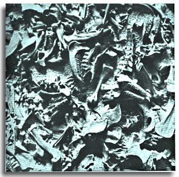
Erratic boulders the world over - myriads of animal bones packed and crushed together in caves all over the globe, void of predation marks (marks on the bone). What could have caused this?
The following two videos show the power of fast, rising water. The first is of the recent Japan Tsunami back in March and was filmed by a delivery man (who survived).
The second video was filmed in Australia, and shows again the power of fast moving water, and its ability to lift massive objects and drop them in the oddest of positions.
Look at the videos below - and imagine that instead of cars, giant boulders are being dragged along with the waves. It is easy to see how water of this kind could rush inland, creating what will be discussed below; Chevrons.
Here is a clip from a flood in Australia last year - notice how, when the water subsides, the cars are strewn about in odd positions. Replace cars with boulders, and you can see the world over is littered with examples like this.
Excerpts from "Earth in Upheaval"
(c) Doubleday 1955
Page 3 - "What could have caused the Artic Sea and the Pacific Ocean to irrupt and wash away forests with all their animal population and throw the entire mingled mass in great heaps scattered all over Alaska, the coast of which is no longer the Atlantic seaboard from Newfoundland to Florida?
Was it not a tectonic revolution in the earth's crust, that also caused the volcano's to erupt and to cover the peninsula with ashes?
In various levels of the muck, stone artifacts were found 'frozen in situ at great depths and in apparent association' with the Ice Age fauna, which implies that 'men were contemporary with extinct animals in Alaska.'
Worked flints, characteristically shaped, called Yuma points, were repeatedly found in the Alaskan muck, one hundred and more feet below the surface. One such spear point was found there 'between a lion's jaw and a mammoth's tusk.'
Similar weapons were used only a few generations ago by Indians of the Athapascan tribe, who camped in the upper Tanana Valley. It has also been suggested that even modern Eskimo points are remarkably Yuma-like, all of which indicates that the multitudes of torn animals and splintered forests date from a time not many thousands of years ago.
The Caves of England -Page 15,
In 1823, William Buckland, professor of geology at the University of Oxford, Published his Reliquiae diluvianae (Relics of the flood), with the subtitle, Observations on the organic remains contained in caves, fissures, and diluvial gravel, and other geological phenomena, attesting the action of an universal deluge. Buckland was one of the great authorities on geology in the first half of the nineteenth century. In a cave in Kirkdale in Yorkshire, eighty feet above the valley, under a floor covering of stalagmites, he found teeth and bones of elephants, rhinoceroses, hippopotami, horses, deer, tigers (teeth of which were larger than those of the largest lion or Bengal tiger), bears, wolves, hyenas, foxes, hares, rabbits, as well as bones of ravens, pigeons, larks, snipe and ducks.
Many of the animals had died 'before the first set, or milk teeth, had been shed.'
The idea which long prevailed, 'was, that they were the remains of elephants imported by the Roman armies. This is also refuted First by the anatomical fact of their belonging to extinct species of this genus, second, by their being usually accompanied by the bones of rhinoceros and hippopotamus, animals that could never have been attached to Roman armies: thirdly, by their being found dispersed over Siberia and North America, in equal or even greater abundance than in those parts of Europe which were subjected to the Roman power.'
The Aquatic Graveyards - Page 19-20,
In the red sandstone an abundant aquatic fauna is embedded. The animals are in disturbed positions. At the period of the past when these formations were composed, 'some terrible catastrophe involved in sudden destruction of the fish of an area at least a hundred miles from boundary to boundary, perhaps much more.
The same pattern in Orkney as at Comarty is strewed thick with remains, which exhibit unequivocally the marks of violent death. The figures are contorted, contracted, curved; the tail in many instances is bent around to the head; the pines stick out; the fins are spread to the full, as in fish that die in convulsions.
The Pterichthys shows its arms extended at their stiffest angle, as if prepared for an enemy. The attitudes of all ichthyolites {any fossil fish} in this platform are attitudes of fear, anger and pain. The remains, too, appear to have suffered nothing from the after-attacks of predacious fishes; none such seem to have survived. The record is one of destruction at once widely spread and total. . .' ~ a thousand localities disclose the same scenes of destruction.
The Asphalt Pit of La Brea - Page 64,
Beds of petroleum shale (rock of laminated structure formed by consolidation of clay), ascribed to the Tertiary Age, having in many places a thickness of about two thousand feet, extend from Cape Mendocino in northern California to Los Angeles and beyond, a distance of over four hundred and fifty miles. The asphalt of Rancho La Brea are an outcrop of this large bituminous formation.
Since 1906 the University of California has been collecting the fossils of Rancho La Brea, 'a most remarkable mass of skeletal material.' When found, these fossils were regarded as representing the fauna of the late Tertiary (Pliocene) or early Pleistocene (Ice Age).
The Pleistocene strata, fifty to one hundred feet thick, over lie the tertiary formations in which the main oil-bearing beds are found. The deposit containing the fossils consists of alluvium, clay, course sand and asphalt. Most spectacular among the animals found at Rancho La Brea is the Saber-tooth tiger (Smilodon), previously unknown elsewhere in the new or old world, but found since then, in other places too. The canine teeth of this animal, over ten inches long, projected from his mouth like two curved knives. With this weapon the tiger tore the flesh of his prey.
The animal remains are crowded together in the asphalt pit in an unbelievable agglomeration. In the first excavation carried on by the University of California 'a bed of bones was encountered in which the number of saber-tooth and wolf skulls together averaged twenty per cubic yard.'
br>No fewer than seven-hundred skulls of saber-toothed tiger have been recovered.' Among other animals unearthed in this pit were bison, horses, camel, sloths, mammoths, mastodons, and also birds including peacocks.
To explain the presence of these bones in the asphalt, the theory was offered that the animals became entrapped in the tar, sank in it, and were imbedded when the tar hardened. However the large number of animals that filled this asphalt bed to overflowing is baffling.
Moreover the vast majority of them are carnivorous, whereas in any fauna the majority of animals would be herbivorous-otherwise the carnivores would have had no victims for their daily food-requires explanation.
Agate Spring Quarry - Page 67,
In Sioux county Nebraska, on the south side of the Niobrara River, in Agate Springs Quarry, is a fossil bearing deposit up to twenty inches thick. The state of the bones indicate a long and violent transportation before they reached their final resting place. '...the fossils are in such remarkable profusion, in places, as to form a veritable pavement of interlacing bones, very few of which are in their natural articulation with one another,' says R.S. Lull, director of the Peabody Museum at Yale, in his book on fossils.'
The profusion of bones in Agate Springs Quarry may be judged by a single block now in the American Museum of Natural History in New York, this block contains about a hundred bones to the square foot. There is no way of explaining an aggregation of fossils as a natural death retreat of animals of various genera.
The animals found were mammals. The most numerous was the small twin horned rhinoceros (Diceratherium). There was another extinct animal (Moropus) with a head not unlike that of a horse but with heavy legs and claws like that of a carnivorous animal. And bones of a giant swine that stood six feet high (Dinohyus hollandi) were also unearthed.
The Carnegie Museum, which likewise excavated in Agate Spring Quarry, in a space of 1350 square feet found 164,000 bones or about 820 skeletons. A mammal skeleton averages 200 bones. This area represents only one-twentieth of the fossil bed in the quarry, suggesting to Lull that the entire area would yield about 16,400 skeletons of the twin-horned rhinoceros, 500 skeletons of the clawed horse, and 100 skeletons of the giant swine.
A few miles to the east, in another quarry were found skeletons of an animal which, because of its similarity to two extant species, is called a gazelle camel (Stenomylus). A herd of these animals was destroyed in a disaster. ~ the transportation was in a violent cataract of water, sand, and gravel, that left marks on the bones. Tens of thousands of animals were carried over an unknown distance, then smashed into a common grave.
The catastrophe was most likely ubiquitous, for these animals-the small twin-horned rhinoceros, clawed horse, giant swine, and gazelle camel-did not survive, but became extinct. ~ the very circumstances in which they are found bespeak a violent death at the hands of the elements, not slow extinction in a process of evolution.
In many other place of the world similar finds have been made in the United States ~ In Switzerland a conglomerate of bones of animals that belong to different climates and habitats were found in Kesslerloch near Thayngen: Alpines types are there in one 'Tiergemiosh' with animals of the steppe and of the forest and fauna. In Germany a gravel pit at Neukoln (a suburb of Berlin)"
Extinction - Page 226,
In numerous places of the world the bone content of caves indicates that they served as hide-outs in times of supreme danger. Lions and tigers, wolves and hyenas, gazelles and hares shared the refuge and there found their common grave. But not all places where such assemblages of bones are discovered were sought for refuge. In many cases the animals were swept from large areas by a tidal wave and thrown against rocks. And the water rushing through the fissures left behind the animals with all their bones broken within their torn bodies. From as far as China, to England and France and the islands of the Mediterranean, examples of fissures of fissures with bones, splintered and mingled together, have been presented in the book.
Not only fissures in the rocks but caverns in the hills may have been filled with bones, though the caverns might not have been sought for shelter. An irrupting sea or great lake, lifted from its bed and carrying its own detritus and land debris, swept heterogeneous herds of animals and carried then to the farthest reaches and threw over them hills of gravel, rock and earth.
Cumberland cave, described on an earlier page, is one of many examples.
http://s8int.com/boneyard5.html
The Ivory Islands, pages 4-6
In 1797 the body of a mammoth, with flesh, skin, and hair, was found in northeastern Siberia. The flesh had the appearance of freshly frozen beef; it was edible, and wolves and sled dogs fed on it without harm. The ground must have been frozen ever since the day of their entombment; had it not been frozen, the bodies of the mammoths would have putrefied in a single summer, but they remained unspoiled for some thousands of years. In some mammoths, when discovered, even the eyeballs were still preserved.
(All) this shows that the cold became suddenly extreme .. and knew no relenting afterward. In the stomachs and between the teeth of the mammoths were found plants and grasses that do not grow now in northern Siberia .. (but are) .. now found in southern Siberia. Microscopic examination of the skin showed red blood corpuscles, which was proof not only of a sudden death, but that the death was due to suffocation either by gases or water.
Whales in the Mountains, pages 46-49
Bones of whale have been found 440 feet above sea level, north of Lake Ontario; a skeleton of another whale was discovered in Vermont, more than 500 feet above sea level; and still another in the Montreal- Quebec area, about 600 feet above sea level. Although the Humphrey whale and beluga occasionally enter the mouth of the St. Lawrence, they do not climb hills.
Times and Dates, pages 202-203
Careful investigation by W.A. Johnston of the Niagara River bed disclosed that the present channel was cut by the falls less than 4,000 years ago. And equally careful investigation of the Bear River delta by Hanson showed that the age of this delta was 3,600 years. The study by Claude Jones of the lakes of the Great Basin showed that these lakes, remnants of larger glacial lakes, have existed only about 3,500 years. Gales obtained the same result on Owen Lake in California and also Van Winkle on Abert and Summer lakes in Oregon.
Radiocarbon analysis by Libby also indicates that plants associated with extinct animals (mastodons) in Mexico are probably only 3,500 years old. Similar conclusions concerning the late survival of the Pleistocene fauna were drawn by various field workers in many parts of the American continent. Suess and Rubin found with the help of radiocarbon analysis that in the mountains of the western United States ice advanced only 3000 years ago.
The Florida fossil beds at Vero and Melbourne proved - by the artifacts found there together with human bones and the remains of animals, many of which are extinct - that these fossil beds were deposited between 2,000 and 4,000 years ago. From observations on beaches in numerous places all over the world, Daly concluded that there was a change in the ocean level, which dropped sixteen to twenty feet 3,500 years ago. Kuenen and others confirmed Daly's findings with evidence derived from Europe.
The Smoking Gun for Rapid Crust Movement? Chevron Deposits and Mega Waves
Above image is taken from a tip of a Chevron Deposit in Madagascar
I was recently introduced to the phenomenon known as 'Chevron Deposits', which needless to say, has had me intrigued.
These formations, as it turns out, are found the world over, along almost every coast line and they stretch inland to over a kilometre - using Google Earth for a few hours earlier today I was able to see such examples covering the entire coast land of Eastern South Africa as well as the Western side of Madagascar, as the below image I took shows.
Wikipedia defines a Chevron as:
(also spelled cheveron, especially in older documents) is an inverted V-shaped pattern. The word is usually used in reference to a kind of fret in architecture, or to a badge or insignia used in military or police uniforms to indicate rank or length of service, or in heraldry and the designs of flags (see flag terminology). The symbol is also used on highway signs to guide drivers around curves.
"Many coastlines of the world exhibit sets of large V-shaped chevron-like dunes - symmetrical sand dunes that are similar in their lancet-form, showing strong parallelism, often in different angles to the shoreline (Bryant, 2001 Kelletat, Scheffers, 2003). Some examples of chevron dunes from different parts of the world ocean coastline are shown in Fig.1. The term "chevron" (specifically, "chevron-shaped pattern in the Selima sand sheet" was first used to describe wind-blown dunes by Maxwell and Haynes (1989) in south-western Egypt and the northern Sudan, where the chevrons consist of sinuous, parallel, blade-shaped deposits of sand, 10-30 cm high and 0.13-1.2 km in length, which actively migrate over darker coarse sands. Hearty et al. (1998) and Kindler and Strasser (2000) applied this term to coastal dunes. They used this term in the Bahamas to describe nested, parabolic shaped dunes formed during the Last Interglacial age and attributed them to megastorm deposits. Bryant (2001) recognized, that certain coastal chevrons could be formed by mega-tsunamis because its limits are far beyond of any storm surges reported in the literature. Only dominant winds or high-energy water currents can be responsible for formation of chevrons. In this paper, we do not limit the term "chevron" to any one process but use it in the broadest sense to refer to any sedimentary feature within the coastal landscape with this distinctive V-shape morphology."
There are some key characteristics that Chevrons presents, which are important when discerning these from dune type formations, or erosional features from wind and sand.
Extreme inundations of the land by ocean water generally leaves traces of what Geologists refer to as lithic (rock fragments, usually from sources elsewhere) or bioclastic (bone) fragments. One thing the small group of geologists currently studying this must distinguish between, is that of the storm surge induced or that of other source, or a tsunami wave. Storm surge waves have somewhat similar characteristics, but they lack the raw power of giant tsunami type waves. Epic waves colliding over the shoreline transports and deposits shells, coral sand and boulders, into and on top of massive mud and sand deposits some reaching 30m in height, or even up to 120m (Kelletat, Scheffers: 184).
Using Google earth, one can see how the chevrons formed along the coast of Africa and Madagascar do not all follow a uniform pattern, some form perpendicular or parallel to the angels of the coastline (ibid: 185). Also one can notice, remnants of older chevrons with plant growth, where new waves have washed over it. In the recent memory of man, and in conjunction with modern historical data - the largest chevrons the world over must have occured in pre-historic times.
"Tsunami boulder deposits contain one or more of the following characteristics: distinct imbrication of boulder clasts with seaward dips, low variance in alignments with a-axes of boulders within a deposit, discrete trains of boulders extending inland, boulders deposited well above storm wave limits and the presence of marine fauna within the deposit" (Nott:692).
Some geologists have suggested that the Chevron formations are due to a meteorite impacting the ocean - causing Tsunami waters to rise up over the shores. Evidence for this is found in impact craters under the ocean - specifically "the 18-mile wide Burckle Crater, located in the centre of the Indian Ocean" (Rowan: Source), it has been found, that some chevron deposists contain meteoritic dust. Another hypothesis is that massive tidal waves due to earthquake activity could have caused global chevrons.
The meteroite hypothesis though does not line up properly to the carbon dating of shells lodged within chevrons - this then begs the question; if meteroites were not the sole cause and Earthquakes could not produce large enough waves as evidence in some chevrons, then what could cause the ocean to roar inland at such great strength, carrying with it boulders, animal life and carving the landscape out, depositing these structures?
A Return to Waves
Velikovsky, in Earth in Upheaval says
"Before the Ice Age theory was concieved, drift and erratic boulders were ascribed to the action of great tidal waves. But with the advent of this theory the role of the water in the deposition of drift and erratic boulders was denied...As we have learned on the preceeding pages, a disturbance in the axial rotation of the earth must have created a displacement of the oceans and their irruption on the land" (Velikovsky: 128)
Could the instances of Chevrons the world over be evidence of an axial tilt in the earth, causing the crust to displace itself over the molten core?"
".that under the impact of a force or the influence of an agent - and the earth does not travel in an empty universe - the axis of the earth shifted or tilted. At that moment an earthquake would make the globe shudder. Air and water would continue to move through inertia; hurricanes would sweep the earth and the seas would rush over continents, carrying gravel and sand and marine animals, and casting them on the land. Heat would be developed, rocks would melt, volcanoes would erupt, and lava would flow from fissures in the ruptured ground and cover vast areas. Mountains would spring up from the plains and would travel and climb on the shoulders of other mountains, causing faults and rifts. Lakes would be tilted and emptied, rivers would change their beds; large land areas with all their inhabitants would slip under the sea. Forests would burn, and the hurricanes and wild seas would wrest them from the ground on which they grew and pile them, branch and root, in huge heaps." (Velikovsky: preface)
The Ancients and Epic Waves
If the chevrons were not formed in recent times, to which modern man would have had testimony to (as in, recent tsunami's or surge storms), then ancient man would have witnessed such events seeing that civilizations first arise along coastal regions.
"The ocean tides are produced by the action of the sun and to a larger extent by that of the moon. A body larger than the moon or one nearer to the earth would act with greater effect. A comet with a head as large as the earth, passing sufficiently close, would raise the waters of the oceans miles high. The slowing down or statis of the earth in its rotation would disturb this poleward recession, drawing the water toward itself."
It is known that the earth is not a complete sphere, but rather is a bulge in the middle - it is flatter on the poles and wider at the equator. Picture clay on a spinning wheel; a natural reaction to constant motion. If the earth were to halt in its rotation, the oceans water pushed towards the equator would suddenly find itself rushing towards the poles - people living along coastlines would have noticed first the massive rise in the tide, followed suddenly by the retreat of the ocean water as it pulls itself towards the poles. The direction of water flow, moving over inland along the way, could have caused some of the chevrons.
"The tradition of many peoples persist that seas were torn apart and their water heaped high and thrown upon the continents. In order to establish that these traditions refer to one and the same event, or at least to an event of the same order, we must keep to this guiding sequence: the great tide followed a disturbance in the motion of the earth...The Chinese annals say that in the time of Emperor Yahou the sun did not go down for ten days, the world was in flames and in "their vast extent the waters over topped the great heights".
The traditions of the people of Peru tell that for a period of time equal to five days and five nights the sun was not in the sky, and then the ocean left the shore and with a terrible din broke over the continent; the entire surface of the earth was changed in a catastrophe. The Choctaw Indians of Oklahoma relate: "The earth was plunged in darkness for a long time - a bright light appeared in the north, "but it was mountain-high-waves, rapidly coming nearer." The Midrashim contain the following description: "The waters were piled up on to the height of the sixteen hundred miles, and they could be seen by all the nations on the earth." (Velikovsky: 57, Worlds in Collision)
Notice how the water, can move up and over structures because of the sheer power behind it - it needs to go someplace, and it finds the easiest path, dragging with it debris of all sorts.
Could many of the chevrons along the coast lines not be indicitive of a force like this, but even stronger. If the axial rotation of the eartth was slow or came to a stop, water leaving the equator and rushing to the poles could at first cause the angular patterns face south along shorelines, then the water needing to equalize, moves back into the equator - creating patterns in the opposite direction. Boulders, marine life, rush into the land, the water carving out its direction, carving out the landscape and depositing giant boulders at the base of cliffs.
Updated: 8/14/2012
Well, it appears that somebody posted a question to Nancy recently regarding Chevrons and Crust displacement, and I can only assume the idea had come from myself - since a search on google a few days back relating the two only brought up my writings on various pages.
Here is ZT on Chevrons:
Chevrons formed from ocean deposits along coastlines are yet another absolute proof that the Earth has experienced regular crustal shifts in her recent past. The pattern in the Chevrons is from the sloshing in the oceans we have predicted - high force, single direction, and height. The Madagascar Chevrons show the angle of assault clearly. In every case, the angle of assault in such Chevrons is from an ocean body, straight in toward land. Scientists who refuse to consider that periodic Pole Shifts happen to Earth struggle to explain them. The angle of assault does not match computer models for tsunami assaults. Evidence for a comet impact, where the waves would be high enough to deposit large amounts of sediment from the ocean floor, is missing.
It is only the large tidal waves we have predicted and described, where the entire ocean is on the move, that such sediment can be swept inland. The tides during the Pole Shift will rise 500-600 feet along coastlines, not crashing down but steadily pushing inland. Why are the formerly prevalent theories just now being challenged - that these coastal Chevrons were caused millions of years ago or were formed by tsunami from comets? Scientists aware of ZetaTalk and the presence of Planet X are taking our warnings seriously, and looking for evidence with which to educate the public.
For now, I need to do more research into the Chevrons - though not much exists. It is a relatively new field, a phenomenon ushered in, really, with Google Earth.
One thing is clear to me though, the dates of the great Chevrons are "Pre-Historic" at best, which gives even more credence to cultural text and lore, and even less credence to the doctrine of uniformity.
ParadigmRevolutions.ning.com
References:
Bourdeiu, Pierre. 1992. The Logic of Practice. Stanford University Press
Foucault, Michel. 1970. The Order of Things (excerpts). New York: Pantheon Books.
Mason, Alan. 2000. The Language of Society: The Cubeo Mourning Ceremony as Example. Social Anthropology 8(3): 231-245.
Rorty, Richard. 1989. The Contingency of Language. In Contingency, Irony and Solidarity. Cambridge: Cambridge University Press
Velikovsky, Immanuel. 1955. Earth in Upheaval. Pocket Books, USA
Whorf, Benjamin Lee. 1988. The Relation of Habitual Thought to Language. In Paul Bohannan and
Mark Glazer, eds., High Points in Anthropology. New York: McGraw-Hill.
Comments
Ok according to Velikovsky, by examining ancient text, that venus was not a planet in the inner solar system? Quite possible, and that it came either from jupiter or beyond, possibly was one of jupiters moons or Saturns? And that by coming past mars and the earth it caused alot of catastrophes before it settled into an eliptical orbit around the sun.By interacting with the earth and causing a pole shift about 3800 or more years ago and for a few more hundred years after that. And that mars was displaced from its orbit and dragged close to the earth by venus and they battled amongst themselves every so often as their orbits came close as well as causing cataclysms on the earth. Then after awhile venus was pushed closer to the sun and assumed it present orbit. While mars was still having alterations with the earth from time to time before it was pushed out to its present orbit. What question remains unanswered here is where did venus come from? Secondly what force caused it to fly past mars and to perturb mars? A magnetic ribbon from beyond the heliosphere. Or a Brown dwarf star coming thru the solar system and jupiter stole venus from it. If venus was the outermost planet of the brown dwarf as it orbited the sun, and venus came close enough to jupiter this would be possible for the theft. It would then be possible for venus not having a good orbit around jupiter, and having a higly elliptical orbit be perturbed by mars and the earth and the sun therby pulling it into the inner solar system. To battle mars and the earth in a tug and pull and push, till they finally sorted out their orbits with the help of the sun as well. According to velikovsky, ancient manuscripts before 3800 years ago did not acknowledge venus as an inner solar system planet. I may have the timing off but the idea is the same. All in all this actually creates more questions than it answers! But i firmly believe we have at the very least a binary start system and that Wormwood or whatever the brown dwarf star is called orbits just outside of our solar system, perhaps itself on a highly elliptical orbit around the sun as binary stars of vastly different sizes would orbit each other in such a manner. Read the Ebook and give me your ideas?
Preston, I get the chevron theory and I agree by the evidence presented. Is there a possibility that BOTH crustal displacement AND Ice movement could be a possible theory?
If we add up 3657 3 times we come up with 10,971 and then subtract 2012 and we get 8959bc. Which is not the figure 9577bc. Then this catacysm by this timeline would have already have had to commence 618 years ago? If all of these timlines were supposed to be correct. Other than that we are talking about at least two different types of cataclysm from two different types of celestial objects. One could understand why a clestial object could take 52 years to pass the earth, go around the sun and come back by the earth again. It would be a normal orbitary path for such said object, then dissappearing in space to return again 3600 years later. A brown dwarf star or, a planet of 4 times the size of Earth or possibly a small remnant of a black dwarf star with a very large trail of debris? Either one would not be good for us.All would have a tail of some kind and be highly magnetic. Yet there seems to be something else? Or could that just be the occasional giant comet landing in the ocean once in awhile? Im going to finish reading Velikovsky and get back. Must have been 20 years or so since i might have last read it.
Oh sorry Tammy, yeah definitely the Earth would have gotta hot with weird weather patterns (like now). The only difference is, I don't believe in the 'ice-age'. See, people see carved rock with striation lines around the globe - clear signs of ice cover, so assume ice must have reached there. However this is counter to what we see, so those areas must have previously been the actual north and south poles - then, through crust displacement, slide out, the caps melt, sea levels rise, then drop back to normal as the new poles form ice cover. I had been trying to figure out the direction of the last crust slip, to match up with more recent Chevron deposits...without an animation it's hard to visualize. Perhaps I will try to make one!
Everything is cyclic and anything that has happened before can happen again. Prior to the last Ice Age, Earth got really hot and had weird weather patterns (at least that is what some researchers have said). I guess that is why I asked about the possibility of another Ice Age. :)
I will try to find a link on Amazon for you....
here it is...
http://www.amazon.com/Cataclysm-Compelling-Evidence-Cosmic-Catastro...
Yeah, I've often thought the whole National Geographic type imagry of the 'Caveman' building homes out of Mammoth or Mastadon bones (after the kill), or cave dwellings themselves may have had more to do with abrupt shifts of climate on the Earth. I actually argued this in an old paper I wrote for an Archaeology class back in 2004.
The fact is, most of the 'Ice Age' animal bones we find show little to no cut marks on them, suggesting we did not kill them. Nor are there predation marks. It is possible, that in the aftermath of something, people simply used debris laying around to shelter themselves
the book is an absolute classic, maybe hard to get a copy these days, one of the most comprehensive scientific and historic treatises on the last great cataclysm that took down the Atlantis civilization and others. about 10000 breeding pairs survived. the myth of the cavemen is simply a race memory of the survivors who escaped to the hills and mountains, and lived in caves until they could restart civilization.
I'll check that one out for sure, I actually have not come upon it - thanks. They are in line with Velikovsy's ideas - though they ascribe the event to a different cause other then Venus. Whatever the 'cause' is, the Earth shows enough evidences to support crust displacement - and testimony to 'something' passing the earth.
Read Alan and Delairs book, 'cataclysm'. last ice age caused by planetary cataclysm, as seen in the geological and historic record. 11500 years ago
-
1
-
2
of 2 Next