
Alaska – 16 Earthquakes , 3.8 to 3.0 Magnitude May 21st – 24th, 2013 : Total of 165 EQ’s in the last 37 days
Earth Watch Report - Earthquakes
….
Not counted in the total used for this report are any quakes under 3.0 There were a total of 26 EQs 2.9 and lower from May 19th to May 24th. For a total of 42 EQ’s in the last 5 days and a grand total of 191 EQs in 37 days
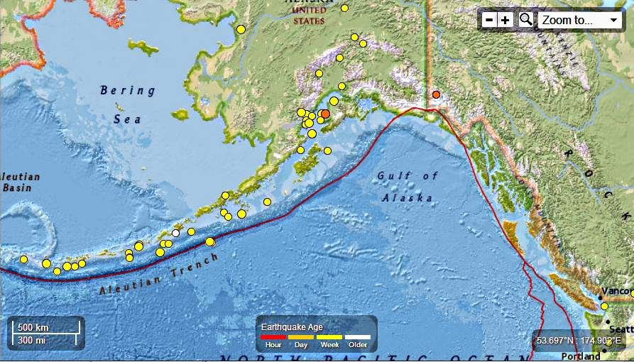
Seismic Activity in the last 7 days
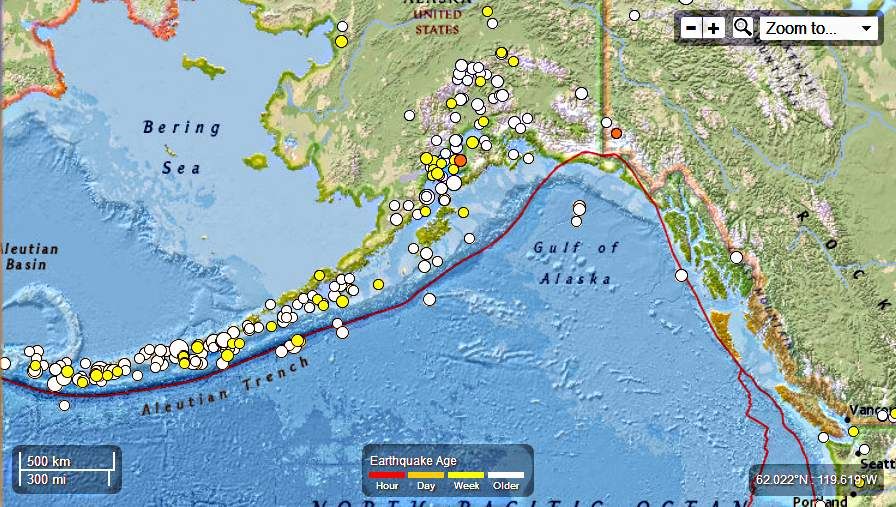
Seismic Activity in the last 30 days
….
M3.3 – 11km S of Yunaska Island, Alaska
2013-05-21 08:56:12 UTC

Event Time
- 2013-05-21 08:56:12 UTC
- 2013-05-20 23:56:12 UTC-09:00 at epicenter
- 2013-05-21 03:56:12 UTC-05:00 system time
Location
52.532°N 170.676°W depth=74.2km (46.1mi)
Nearby Cities
- 11km (7mi) S of Yunaska Island, Alaska
- 1519km (944mi) SSE of Anadyr’, Russia
- 1582km (983mi) WSW of Anchorage, Alaska
- 1611km (1001mi) WSW of Knik-Fairview, Alaska
- 2332km (1449mi) W of Whitehorse, Canada
….
M3.0 – 67km S of Tanaga Volcano, Alaska
2013-05-21 10:27:31 UTC

Event Time
- 2013-05-21 10:27:31 UTC
- 2013-05-20 22:27:31 UTC-12:00 at epicenter
- 2013-05-21 05:27:31 UTC-05:00 system time
Location
51.277°N 178.098°W depth=14.7km (9.1mi)
Nearby Cities
- 67km (42mi) S of Tanaga Volcano, Alaska
- 1522km (946mi) SSE of Anadyr’, Russia
- 1596km (992mi) E of Petropavlovsk-Kamchatskiy, Russia
- 1613km (1002mi) E of Yelizovo, Russia
- 2821km (1753mi) W of Whitehorse, Canada
….
M3.8 – 42km SW of Chernabura Island, Alaska
2013-05-21 15:59:08 UTC

Event Time
- 2013-05-21 15:59:08 UTC
- 2013-05-21 04:59:08 UTC-11:00 at epicenter
- 2013-05-21 10:59:08 UTC-05:00 system time
Location
54.547°N 160.077°W depth=32.9km (20.4mi)
Nearby Cities
- 42km (26mi) SW of Chernabura Island, Alaska
- 955km (593mi) SW of Anchorage, Alaska
- 990km (615mi) SW of Knik-Fairview, Alaska
- 1335km (830mi) SW of Fairbanks, Alaska
- 1626km (1010mi) W of Juneau, Alaska
….
M3.3 – 11km S of Yunaska Island, Alaska
2013-05-21 08:56:12 UTC
Event Time
- 2013-05-21 08:56:12 UTC
- 2013-05-20 23:56:12 UTC-09:00 at epicenter
- 2013-05-21 03:56:12 UTC-05:00 system time
Location
52.532°N 170.676°W depth=74.2km (46.1mi)
Nearby Cities
- 11km (7mi) S of Yunaska Island, Alaska
- 1519km (944mi) SSE of Anadyr’, Russia
- 1582km (983mi) WSW of Anchorage, Alaska
- 1611km (1001mi) WSW of Knik-Fairview, Alaska
- 2332km (1449mi) W of Whitehorse, Canada
….
M3.0 – 67km S of Tanaga Volcano, Alaska
2013-05-21 10:27:31 UTC
Event Time
- 2013-05-21 10:27:31 UTC
- 2013-05-20 22:27:31 UTC-12:00 at epicenter
- 2013-05-21 05:27:31 UTC-05:00 system time
Location
51.277°N 178.098°W depth=14.7km (9.1mi)
Nearby Cities
- 67km (42mi) S of Tanaga Volcano, Alaska
- 1522km (946mi) SSE of Anadyr’, Russia
- 1596km (992mi) E of Petropavlovsk-Kamchatskiy, Russia
- 1613km (1002mi) E of Yelizovo, Russia
- 2821km (1753mi) W of Whitehorse, Canada
….
M3.8 – 42km SW of Chernabura Island, Alaska
2013-05-21 15:59:08 UTC
Event Time
- 2013-05-21 15:59:08 UTC
- 2013-05-21 04:59:08 UTC-11:00 at epicenter
- 2013-05-21 10:59:08 UTC-05:00 system time
Location
54.547°N 160.077°W depth=32.9km (20.4mi)
Nearby Cities
- 42km (26mi) SW of Chernabura Island, Alaska
- 955km (593mi) SW of Anchorage, Alaska
- 990km (615mi) SW of Knik-Fairview, Alaska
- 1335km (830mi) SW of Fairbanks, Alaska
- 1626km (1010mi) W of Juneau, Alaska
….
M3.0 – 35km N of Anchor Point, Alaska
2013-05-22 01:06:20 UTC

Event Time
- 2013-05-22 01:06:20 UTC
- 2013-05-21 17:06:20 UTC-08:00 at epicenter
- 2013-05-21 20:06:20 UTC-05:00 system time
Location
60.093°N 151.776°W depth=56.1km (34.9mi)
Nearby Cities
- 35km (22mi) N of Anchor Point, Alaska
- 161km (100mi) SW of Anchorage, Alaska
- 197km (122mi) SW of Knik-Fairview, Alaska
- 568km (353mi) SSW of Fairbanks, Alaska
- 921km (572mi) W of Whitehorse, Canada
….
M3.2 – 59km SSE of Semisopochnoi Island, Alaska
2013-05-22 10:02:47 UTC

Event Time
- 2013-05-22 10:02:47 UTC
- 2013-05-22 22:02:47 UTC+12:00 at epicenter
- 2013-05-22 05:02:47 UTC-05:00 system time
Location
51.431°N 179.826°E depth=69.0km (42.9mi)
Nearby Cities
- 59km (37mi) SSE of Semisopochnoi Island, Alaska
- 1452km (902mi) E of Petropavlovsk-Kamchatskiy, Russia
- 1469km (913mi) E of Vilyuchinsk, Russia
- 1470km (913mi) E of Yelizovo, Russia
- 2924km (1817mi) W of Whitehorse, Canada
….
M3.0 – 27km NNE of Sterling, Alaska
2013-05-22 16:26:11 UTC
Event Time
- 2013-05-22 16:26:11 UTC
- 2013-05-22 08:26:11 UTC-08:00 at epicenter
- 2013-05-22 11:26:11 UTC-05:00 system time
Location
60.766°N 150.576°W depth=52.5km (32.6mi)
Nearby Cities
- 27km (17mi) NNE of Sterling, Alaska
- 62km (39mi) SW of Anchorage, Alaska
- 98km (61mi) SSW of Knik-Fairview, Alaska
- 475km (295mi) SSW of Badger, Alaska
- 844km (524mi) W of Whitehorse, Canada
…
M3.1 – 72km WSW of Redoubt Volcano, Alaska
2013-05-23 05:58:36 UTC

Event Time
- 2013-05-23 05:58:36 UTC
- 2013-05-22 21:58:36 UTC-08:00 at epicenter
- 2013-05-23 00:58:36 UTC-05:00 system time
Location
60.182°N 153.912°W depth=199.8km (124.1mi)
Nearby Cities
- 72km (45mi) WSW of Redoubt Volcano, Alaska
- 247km (153mi) WSW of Anchorage, Alaska
- 277km (172mi) WSW of Knik-Fairview, Alaska
- 608km (378mi) SW of Fairbanks, Alaska
- 1036km (644mi) W of Whitehorse, Canada
….
M3.1 – 86km SSE of Nikolski, Alaska
2013-05-23 19:08:50 UTC

Event Time
- 2013-05-23 19:08:50 UTC
- 2013-05-23 08:08:50 UTC-11:00 at epicenter
- 2013-05-23 14:08:50 UTC-05:00 system time
Location
52.193°N 168.485°W depth=11.0km (6.8mi)
Nearby Cities
- 86km (53mi) SSE of Nikolski, Alaska
- 1508km (937mi) WSW of Anchorage, Alaska
- 1540km (957mi) SW of Knik-Fairview, Alaska
- 1612km (1002mi) SE of Anadyr’, Russia
- 2237km (1390mi) W of Whitehorse, Canada
….
M3.5 – 75km WSW of Anchor Point, Alaska
2013-05-23 20:31:31 UTC
Event Time
- 2013-05-23 20:31:31 UTC
- 2013-05-23 12:31:31 UTC-08:00 at epicenter
- 2013-05-23 15:31:31 UTC-05:00 system time
Location
59.610°N 153.131°W depth=102.1km (63.4mi)
Nearby Cities
- 75km (47mi) WSW of Anchor Point, Alaska
- 252km (157mi) SW of Anchorage, Alaska
- 287km (178mi) SW of Knik-Fairview, Alaska
- 646km (401mi) SSW of Fairbanks, Alaska
- 1008km (626mi) W of Whitehorse, Canada
….
M3.1 – 212km SE of Akutan, Alaska
2013-05-24 04:36:38 UTC

Event Time
- 2013-05-24 04:36:38 UTC
- 2013-05-23 17:36:38 UTC-11:00 at epicenter
- 2013-05-23 23:36:38 UTC-05:00 system time
Location
52.850°N 163.410°W depth=33.1km (20.6mi)
Nearby Cities
- 212km (132mi) SE of Akutan, Alaska
- 1236km (768mi) SW of Anchorage, Alaska
- 1270km (789mi) SW of Knik-Fairview, Alaska
- 1602km (995mi) SW of College, Alaska
- 1909km (1186mi) W of Juneau, Alaska
….
M3.0 – 28km SSW of Cohoe, Alaska
2013-05-25 04:04:34 UTC
Event Time
- 2013-05-25 04:04:34 UTC
- 2013-05-24 20:04:34 UTC-08:00 at epicenter
- 2013-05-24 23:04:34 UTC-05:00 system time
Location
60.121°N 151.419°W depth=57.6km (35.8mi)
Nearby Cities
- 28km (17mi) SSW of Cohoe, Alaska
- 147km (91mi) SW of Anchorage, Alaska
- 183km (114mi) SSW of Knik-Fairview, Alaska
- 558km (347mi) SSW of Badger, Alaska
- 901km (560mi) W of Whitehorse, Canada
….
Related articles
- Alaska – 16 Earthquakes , 4.3 to 2.5 Magnitude May 15th – 16th – 17th, 2013 : Total of 142 EQ’s in the last 30 days (familysurvivalprotocol.com)
- Alaska – 8 EQ’s ranging from 3.2 to2.6 magnitude April 30th, 2013 : Total of 83 Earthquakes in the last 17 days (familysurvivalprotocol.com)
- Alaska – 7 Earthquakes , 3.3 to 2.5 Magnitude May 18th, 2013 : Total of 149 EQ’s in the last 31 days (familysurvivalprotocol.com)
- Alaska – 5 Earthquakes , 3.0 to 2.6 Magnitude May 18th, 2013 : Total of 149 EQ’s in the last 31 days (familysurvivalprotocol.com)
- Alaska – 5 Earthquakes , 4.5 to 2.6 Magnitude May 14th, 2013 : Total of 126 EQ’s in the last 27 days (familysurvivalprotocol.com)
- Alaska – 16 Earthquakes Ranging from 4.5 to 2.5 Magnitude in the last 3 days May 7th – 9th, 2013 : Total of 119 EQ’s in the last 25 days (familysurvivalprotocol.com)
- Alaska – 6 Earthquakes Ranging From 3.2 to 2.5 Magnitude : Total of 89 EQ’s in the last 18 days (familysurvivalprotocol.com)
- Alaska – 6 Earthquakes Ranging From 4.5 to 2.5 Magnitude May 2nd, 2013 : Total of 95 EQ’s in the last 19 days (familysurvivalprotocol.com)
- Alaska – 2 Earthquakes , 4.8 to 4.2 Magnitude May 10th, 2013 : Total of 121 EQ’s in the last 26 days (familysurvivalprotocol.com)
- Alaska – Nineteen Earthquakes Ranging From 5.1 to 2.5 Magnitude April 22nd and 23rd , 2013. A Total of 75 EQ’s in the last 10 days (familysurvivalprotocol.com)
Comments