I talked to a magnetic scientest who worked in an underground facility, who told me that the magnetic lines move yearly from right to left accross the US, at about 1 inch per year. That was in the 80's when I was doing research for my book. There are two types of lines! Isogenics, which are lines of equal declinations and isoclinics which are equal lines of dip. We talked about magnetic Zero, which in the US is at Gary, Indiana. He offered to sell me some government made mapes and said that I could buy several from one of the gov. departments. A minors compus also know as a spanish dip needle measures the dip in the magnetic field. I had a theory that if there are dips in the field that iron meteorites might be drawn into the dip and have a trijectory that would lead them to Rosevelt County New Mexico.
Directional drillers use the Earth’s magnetic field as a natural reference frame to orient the drill bit. The azimuth of the bottom-hole assembly is inferred by comparing the magnetic field measured while drilling (MWD) with a geomagnetic reference field. Crustal magnetic anomalies constitute a significant source of error in directional drilling, if not accounted for in the geomagnetic reference field. To meet increasing demand for accurate geomagnetic referencing, the U.S. National Geophysical Data Center (NGDC) produces the High Definition Geomagnetic Model (HDGM) which accounts for long-wavelength crustal magnetic anomalies. HDGM significantly reduces geomagnetic referencing errors.
The HDGM model includes:
Main field
Secular variation
Crustal field to degree 720
Basic model for external field
Software
The HDGM model is:
Updated annually (current version is HDGM2012)
Available as an NGDC product at annual charge of $19,997.
Geomagnetic declination maps for two drill sites (red crosses) at the Caspian Sea. The standard approach (left) does not account for crustal anomalies and therefore is unrealistically smooth. The advanced approach (middle) shows the long-wavelength crustal distortion accounted for by the global HDGM model. The best solution (right) makes additional use of an aeromagnetic survey to fully account for local distortion of the geomagnetic field.
The Earth's internal magnetic field is a superposition of the field generated by the geodynamo in the liquid outer core (main field) and the field of magnetized rocks in the crust and upper mantle. The main field dominates the long wavelengths, whereas the crustal field dominates at wavelengths smaller than 2500 km.
Geomagnetic field models are conveniently represented as spherical harmonic expansions of a scalar magnetic potential. Such a model can then be evaluated at any desired location to provide the magnetic field vector, its direction, and strength. The standard World Magnetic Model uses a spherical harmonic representation to degree and order 12, resolving the magnetic field at 3000 km wavelength. In contrast, the Enhanced Magnetic Model (EMM) extends to degree and order 720, resolving magnetic anomalies down to 56 km wavelength (see comparison in the figure). The higher resolution of the EMM results in significantly improved pointing accuracy.
The EMM model was compiled from satellite, marine, aeromagnetic and ground magnetic surveys (see our acknowledgement of data providers and collaborators).
Why is this important?
Many different applications utilize Earth's magnetic field,whether for navigation, resource evaluation, or research. The magnetic field experienced at or near the Earth's surface is a combination of the main magnetic field, the relatively static crustal magnetic field, and the rapidly time-varying external magnetic field (solar origin). The better we are able to define these fields, the more accurate the results.
The Enhanced Magnetic Model is now expanded to years 2000 through 2015. To extend the model from 2010 back to 2000 the EMM's main field coefficients are replaced with the first 15 degrees of the Pomme 7 model.
NGDC hosts online calculators to compute the geomagnetic field at any location on the Earth. The geomagnetic models behind these calculators are regularly updated to maintain their accuracy. We are currently hosting revised on-line calculators for the IGRF (1900-2015), DoD WMM (2010-2015), Declination only (1900-2015), and US Historic Declination (1750-2015).
Maps
The world maps of all the components of the geomagnetic field, calculated from the latest WMM model (WMM2010) are available for at the WMM home page (click the map on the lower left). Use the IAGA Web Image Spreadsheet Tool (Wist) to display and download IGRF magnetic field maps and data from 1900 - 2015. The Wist allows the user to select the number of rows (years) and columns (magnetic elements) to display. Each "cell" of the Wist displays the appropriate map for the selected year and element and links to the PDF for a higher resolution version of the map and to the data used to create the map.
Geomagnetic main-field models
Because the Earth's magnetic field is constantly changing, it is impossible to accurately predict what the field will be at any point in the very distant future. By constantly measuring the magnetic field, we can observe how the field is changing over a period of years. Using this information, it is possible to create a mathematical representation of the Earth's main magnetic field and how it is changing. Since the field changes the way it is changing, new observations must continually be made and models generated to accurately represent the magnetic field as it is. NGDC participates in the development and distribution of two global main-field models, the World Magnetic Model and the International Geomagnetic Reference Field Model. The WMM is the standard navigation model for the U.S. and U.K. Departments of Defense and NATO. The IGRF is the international research reference model. To learn more about these models, visit the home Web sites for the US / UK World Magnetic Model (WMM) 2010 and IAGA IGRF-11. You can download the models for use on your own machine, or compute magnetic field values online from the current IGRF model. Before using the IGRF please look at the 'Health Warning'.
High Resolution Models
NGDC also provides geomagnetic models with higher spatial resolution than the above models. These models include the magnetic field contribuions from the Earth's crust. These models are suitable for applications where higher navigational accuracy is required.
The EMM2010 is an epoch 2010 release of the Enhanced Magnetic Model, intended to calculate the magnetic field for both the Earth's internal magnetic field as well as the crustal field. It extends to degree and order 720, resolving magnetic anomalies down to 56 km wavelength. It is updated along the same schedule as the standard World Magnetic Model.
The HDGM is a product of NGDC which is updated annually. The annual charge for the model is $19,997. It includes the internally generated Main Field, the secular variation of the field, the crustal field to degree and order 720, and a basic model for the external field. To purchase the model contact us. For more details and case studies see: http://geomag.us/models/HDGM.html.


Comments
Very Cool theory Jim, thank you for sharing.
I talked to a magnetic scientest who worked in an underground facility, who told me that the magnetic lines move yearly from right to left accross the US, at about 1 inch per year. That was in the 80's when I was doing research for my book. There are two types of lines! Isogenics, which are lines of equal declinations and isoclinics which are equal lines of dip. We talked about magnetic Zero, which in the US is at Gary, Indiana. He offered to sell me some government made mapes and said that I could buy several from one of the gov. departments. A minors compus also know as a spanish dip needle measures the dip in the magnetic field. I had a theory that if there are dips in the field that iron meteorites might be drawn into the dip and have a trijectory that would lead them to Rosevelt County New Mexico.
International Geomagnetic Reference Field (IGRF-11)
[Reference]
IAGA V-MOD Geomagnetic Field Modeling: International Geomagnetic Re...
High Definition Geomagnetic Model
Directional drillers use the Earth’s magnetic field as a natural reference frame to orient the drill bit. The azimuth of the bottom-hole assembly is inferred by comparing the magnetic field measured while drilling (MWD) with a geomagnetic reference field. Crustal magnetic anomalies constitute a significant source of error in directional drilling, if not accounted for in the geomagnetic reference field. To meet increasing demand for accurate geomagnetic referencing, the U.S. National Geophysical Data Center (NGDC) produces the High Definition Geomagnetic Model (HDGM) which accounts for long-wavelength crustal magnetic anomalies. HDGM significantly reduces geomagnetic referencing errors.
The HDGM model includes:
The HDGM model is:
Geomagnetic declination maps for two drill sites (red crosses) at the Caspian Sea. The standard approach (left) does not account for crustal anomalies and therefore is unrealistically smooth. The advanced approach (middle) shows the long-wavelength crustal distortion accounted for by the global HDGM model. The best solution (right) makes additional use of an aeromagnetic survey to fully account for local distortion of the geomagnetic field.
For further details and case studies see: http://geomag.us/models/HDGM.html
Enhanced Magnetic Model (EMM2010)
The Earth's internal magnetic field is a superposition of the field generated by the geodynamo in the liquid outer core (main field) and the field of magnetized rocks in the crust and upper mantle. The main field dominates the long wavelengths, whereas the crustal field dominates at wavelengths smaller than 2500 km.
Geomagnetic field models are conveniently represented as spherical harmonic expansions of a scalar magnetic potential. Such a model can then be evaluated at any desired location to provide the magnetic field vector, its direction, and strength. The standard World Magnetic Model uses a spherical harmonic representation to degree and order 12, resolving the magnetic field at 3000 km wavelength. In contrast, the Enhanced Magnetic Model (EMM) extends to degree and order 720, resolving magnetic anomalies down to 56 km wavelength (see comparison in the figure). The higher resolution of the EMM results in significantly improved pointing accuracy.
The EMM model was compiled from satellite, marine, aeromagnetic and ground magnetic surveys (see our acknowledgement of data providers and collaborators).
Why is this important?
Many different applications utilize Earth's magnetic field,whether for navigation, resource evaluation, or research. The magnetic field experienced at or near the Earth's surface is a combination of the main magnetic field, the relatively static crustal magnetic field, and the rapidly time-varying external magnetic field (solar origin). The better we are able to define these fields, the more accurate the results.
Acknowledgments
Changes to the code
These links will help explain the basis behind the graphs.
Online Calculators
 Checkout our new online calculators!
The old calculators will be phased out December 2012.
NGDC hosts online calculators to compute the geomagnetic field at any location on the Earth. The geomagnetic models behind these calculators are regularly updated to maintain their accuracy. We are currently hosting revised on-line calculators for the IGRF (1900-2015), DoD WMM (2010-2015), Declination only (1900-2015), and US Historic Declination (1750-2015).
Maps
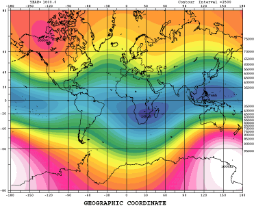
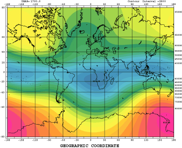
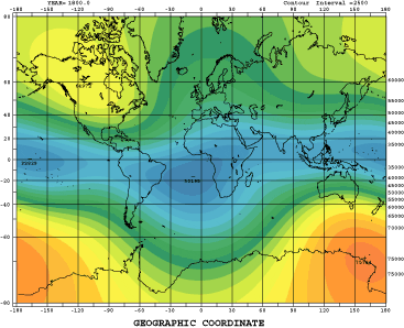
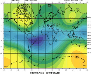
The world maps of all the components of the geomagnetic field, calculated from the latest WMM model (WMM2010) are available for at the WMM home page (click the map on the lower left). Use the IAGA Web Image Spreadsheet Tool (Wist) to display and download IGRF magnetic field maps and data from 1900 - 2015. The Wist allows the user to select the number of rows (years) and columns (magnetic elements) to display. Each "cell" of the Wist displays the appropriate map for the selected year and element and links to the PDF for a higher resolution version of the map and to the data used to create the map.
Geomagnetic main-field models
Because the Earth's magnetic field is constantly changing, it is impossible to accurately predict what the field will be at any point in the very distant future. By constantly measuring the magnetic field, we can observe how the field is changing over a period of years. Using this information, it is possible to create a mathematical representation of the Earth's main magnetic field and how it is changing. Since the field changes the way it is changing, new observations must continually be made and models generated to accurately represent the magnetic field as it is. NGDC participates in the development and distribution of two global main-field models, the World Magnetic Model and the International Geomagnetic Reference Field Model. The WMM is the standard navigation model for the U.S. and U.K. Departments of Defense and NATO. The IGRF is the international research reference model. To learn more about these models, visit the home Web sites for the US / UK World Magnetic Model (WMM) 2010 and IAGA IGRF-11. You can download the models for use on your own machine, or compute magnetic field values online from the current IGRF model. Before using the IGRF please look at the 'Health Warning'.
High Resolution Models
NGDC also provides geomagnetic models with higher spatial resolution than the above models. These models include the magnetic field contribuions from the Earth's crust. These models are suitable for applications where higher navigational accuracy is required.
The EMM2010 is an epoch 2010 release of the Enhanced Magnetic Model, intended to calculate the magnetic field for both the Earth's internal magnetic field as well as the crustal field. It extends to degree and order 720, resolving magnetic anomalies down to 56 km wavelength. It is updated along the same schedule as the standard World Magnetic Model.
The HDGM is a product of NGDC which is updated annually. The annual charge for the model is $19,997. It includes the internally generated Main Field, the secular variation of the field, the crustal field to degree and order 720, and a basic model for the external field. To purchase the model contact us. For more details and case studies see: http://geomag.us/models/HDGM.html.
Please forgive my ignorance, but what do the colors represent? I see there is a drastic change but am unsure from where to what. :)