Jeff Rense
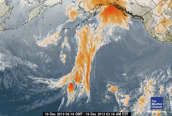
‘This WAS a normal, large Northern Pacific storm system for December. Note how it stretches from Alaska to down past Hawaii.
The first satellite photo below was taken on Dec 19. The day before, December 18, the storm was about TWICE as big. I did not catch that photo.
There is a giant high pressure blocking system off the Pacific Coast and you can see this very large storm, moving left to right in the following photos, has run smack into it. The near vertical part of the system shows how it has been stopped cold.
There have been very, very few storms that have made it to west coast since October.
This storm formed up off the Kamchatka Peninsula, Korea…and northern Japan. It swirled, counter-clockwise right over Fukushima prefecture in its early formation cycle.
We are fortunate few storms have made landfall this fall and winter as it is very likely they have all been carrying varying amounts of radiation. This blocking high pressure is about to shred this particular big storm as you will see in the photos below…
I am almost wondering if ‘they’ are blocking all the storms in order to prevent mass dumping of radiation all up and down the West Coast and into the Sierras and Cascade snowpack. And then, of course, on to the Rockies…
OK, here is out first satellite photo. Remember, this storm was bigger the day before this photo was taken. Watch closely and you will see how this storm is ripped to pieces and bled dry…
Later, the same day, December 19, you can see that the left 2/3 of the storm has continued and run right into and over it’s first 1/3…as both are now blocked solidly by the high pressure…
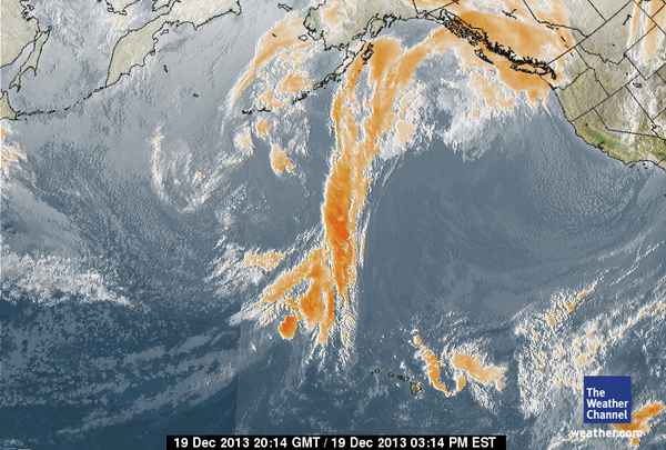
Moisture now stacking up BEHIND the dead-in-the-water storm which is also breaking up.
We have have NO NORMAL STORMS this fall or winter…just pieces of moisture that move through…The storm is now basically dead in the water and being pressed right into the blocking high pressure. It is beginning to lose it’s moisture.
Look way to the left and you’ll see the NEXT storm forming off the Japan area and beginning to move left to right across the Pacific…
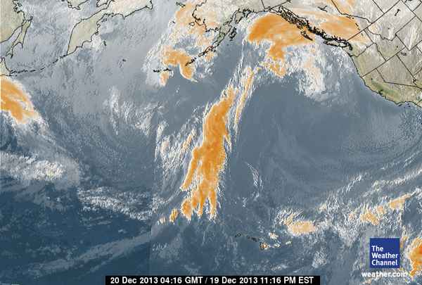
Our FIRST storm is being seriously shredded by the high pressure. The next storm behind it is pulling radiation straight off Fukushima and is, as you notice, composed of chunks of moisture…it is not a traditional nice counter-clockwise spiral. weather system. It is more like random chunks of moisture. It will have the same fate as the current dying system in front of it.
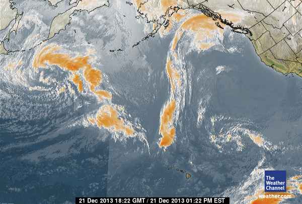
Storm number one is now almost gone…a ghost of its once powerful self. A storm like that could have dumped a foot of snow in the Sierras had it not been stopped. hmm…
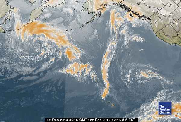
Our first storm is trash now. And storm number 2 is losing its strength rapidly. Go back up to the top of this page and look at the first satellite photo and note how big and strong storm number one was…
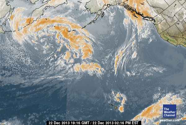
The small, tattered remnants of storm number one are now just sitting. Storm number 2 seems to be still trying to hold ‘form’ but it is being broken into pieces.
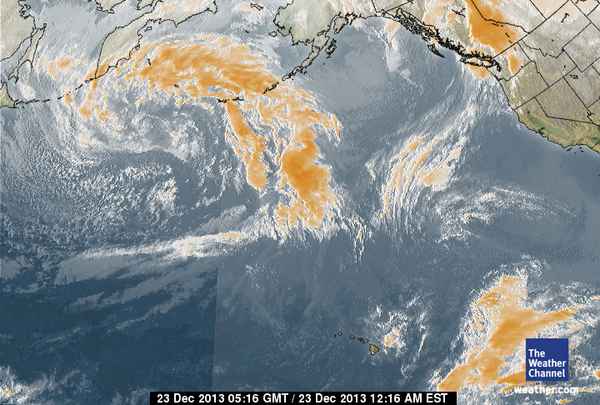
Massive storm #1 is now just a wisp and still barely moving. Most of its moisture has gone back into the sea. Storm number 2 is a mess with little classic form…not unlike a mutated tomato in Fukushima. It has also hit the high pressure wall and is falling apart
Notice there is a storm down to the right, east of Hawaii.. These winter storms coming off the warm tropical waters will sometimes make it to California. These storms are referred to coming in on ‘The Pineapple Express’. If this one makes it to California, it will do so with little or no radiation.
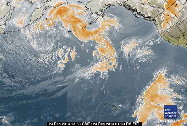
In this photo, storm number two is still rammed into the high pressure and stalled. It has even had its bottom end bent backwards at a 90 degree angle.
In our final photo, storm number one is just an echo of its once mighty self. Storm number 2 has been broken into two pieces and has about a zero chance of making it to California, Oregon and Washington. It would be nice to think that ‘someone’ has been creating that high pressure to keep us from being hit by radioactive rain and snow, no matter how concentrated it might be.
We already have an entire ocean-full of radioactive nuclides to deal with. Just ask the whales, dolphins, seals, orcas and countless fish trying to swim away from the approaching massive Fukushima plume of death which is formally due to hit the West Coast in 3-5 months. The vanguard of it has already arrived on its beaches…
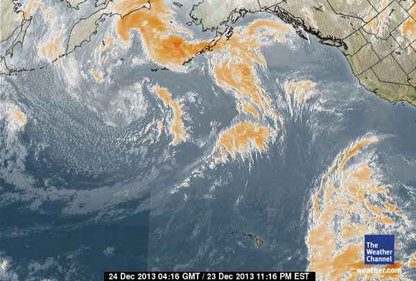
If you want to keep watching these satellite photos, go HERE
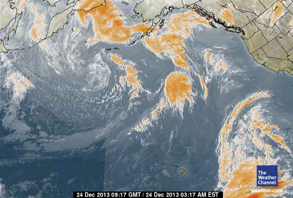
Moisture now stacking up BEHIND the dead-in-the-water storm which is also breaking up. We have have NO NORMAL STORMS this fall or winter…just pieces of moisture that move through…The storm is now basically dead in the water and being pressed right into the blocking high pressure. It is beginning to lose it’s moisture. Look way to the left and you’ll see the NEXT storm forming off the Japan area and beginning to move left to right across the Pacific…

Comments
Then again maybe it is going into the upper atmosphere and the jet stream.
I wondered if they are using HAARP to keep the radiation back until they are ready for it to hit us. Maybe this is why readings aren't as bad as we've been thinking they should be.
Where there is truth there is equal and opposite disinformation. That came to me yesterday while I was reading a blog that was suspicious.
Wonder where it is coming from, the occurrence is too unnatural to be an accident. This does create another problem more drought in an already dry starving for water western US. What looks good may be a problem we are not looking at. HMMM
Wow, it certainly does look like we are getting help.