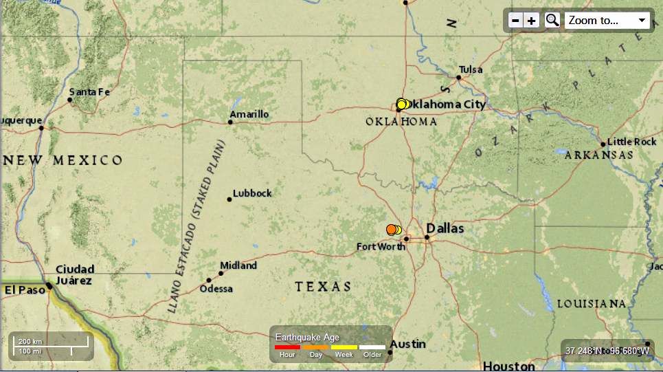
Earth Watch Report

North Texas and Southern Oklahoma 13 EQ in the last 7 days Landslides reported 11-09-2013
13 earthquakes in map area
M 3.0 - 4km S of Springtown, Texas 2013-11-09 13:54:31 UTC-06:00 5.0 km
M 2.7 - 7km SSE of Edmond, Oklahoma 2013-11-08 00:29:40 UTC-06:00 5.0 km
M 2.5 - 5km SSE of Edmond, Oklahoma 2013-11-08 00:03:17 UTC-06:00 5.0 km
M 3.2 - 7km SE of Edmond, Oklahoma 2013-11-07 23:50:05 UTC-06:00 5.0 km
M 2.9 - 4km ESE of Springtown, Texas 2013-11-07 22:32:57 UTC-06:00 4.8 km
M 2.7 - 6km E of The Village, Oklahoma 2013-11-07 16:50:15 UTC-06:00 5.0 km
M 2.7 - 5km SSW of Springtown, Texas 2013-11-06 11:05:48 UTC-06:00 5.0 km
M 2.6 - 2km ESE of Reno, Texas2013-11-05 21:32:09 UTC-06:00 5.0 km
M 3.2 - 7km NW of Spencer, Oklahoma 2013-11-05 02:32:47 UTC-06:00 5.0 km
M 2.5 - 1km SSE of Edmond, Oklahoma 2013-11-05 00:13:07 UTC-06:00 5.0 km
M 3.8 - 5km WNW of Jones, Oklahoma 2013-11-04 22:01:35 UTC-06:00 5.9 km
M 3.3 - 6km N of Spencer, Oklahoma 2013-11-03 19:52:02 UTC-06:00 7.1 km
M 2.7 - 8km WNW of Jones, Oklahoma 2013-11-02 19:41:53 UTC-06:00 5.0 km
..........
| Today | Landslide | USA | State of Texas, Springtown |
..........
Landslide in USA on Saturday, 09 November, 2013 at 05:02 (05:02 AM) UTC.
| Description | |
| A Springtown family is concerned about the integrity of its home since several sinkholes started appearing on its four-acre property four months ago. Tracey Napier said she is very nervous about them. "I'm not a worrywart, but I'm very worried about this," she said. None of the holes appear to be deeper than a foot and most are quite small in diameter, but the results, the family says, are apparent. There is a large crack in the master bedroom window, and the front screen door appears to be out-of-line with the door frame. A fence post that was painted white all the way down to the ground several years ago now shows between one-and-a-half inches to two inches of unpainted wood at the bottom. The Napier family's frustration began before five earthquakes shook the ground in the area around its community in the past seven days. Earthquakes were detected near the Mid-Cities, Reno and Springtown from Nov. 1-7. The U. S. Geological Survey reports a 2.1 magnitude quake was centered 1 mile southeast of Richland Hills just before noon on Nov. 1. Then, on Tuesday, a minor earthquake was reported near Azle. According to the U.S. Geological Survey's website, the magnitude-2.6 earthquake hit about 1 mile east-southeast of Reno and about 2 miles north of Azle at about 9:32 p.m. An aftershock to that earthquake was also felt Tuesday night at about 10 p.m. Wednesday was another shaky day in North Texas. The U.S. Geological Survey said a 2.7-magnitude earthquake was detected at 11:05 a.m. about 26 miles northwest of Fort Worth near Springtown. According to the Modified Mercalli Intensity Scale, the vibration would have felt like passing heavy trucks. Stopped cars would rock, hanging objects to swing, windows, dishes and doors to rattle, glasses to clink and wooden walls and frames creak. There were no reports of injuries or damage in any of the earthquakes. Napier said her sinkholes and the nearby earthquakes are "just crazy." Adding to the Napier family's frustration is that they have yet to receive a clear answer explaining why any of this is happening. The family has reached out to the Parker County Commission, the Texas Commission on Environmental Quality, the Texas Department of Agriculture and other government agencies, but has gotten no explanation, Napier said. |
..........


Comments
True that.
Athough many of the earthquakes being registered in Texas are in areas where fracking is taking place USGS and RSOE EDIS rarely put the two together in their reports unless they have corroborating studies. I suppose we won't know if these correspond to fracking areas until someone puts the data together. Because it surely will not come from either of these two organizations.Not without a push anyways.....
Is this due to fracking?