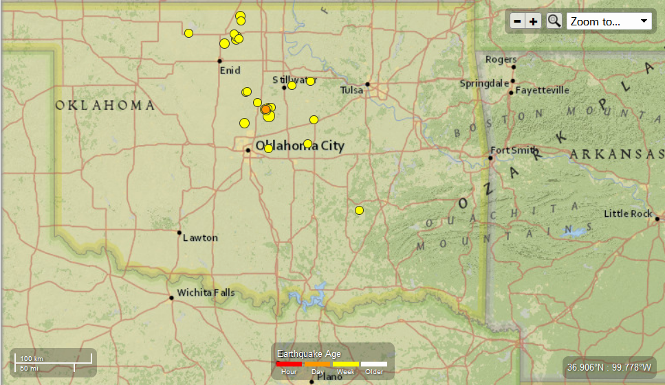
Earth Watch Report - Earthquakes
31 earthquakes in map area
M 2.7 - 6km SSW of Langston, Oklahoma
2014-03-26 09:24:20 UTC-05:00 5.0 km
M 2.6 - 31km WSW of McAlester, Oklahoma
2014-03-25 15:52:17 UTC-05:00 5.0 km
M 3.4 - 12km NW of Edmond, Oklahoma
2014-03-25 09:01:19 UTC-05:00 6.1 km
M 2.8 - 4km NNW of Stroud, Oklahoma
2014-03-24 18:32:46 UTC-05:00 7.8 km
M 2.7 - 10km E of Medford, Oklahoma
2014-03-24 10:39:59 UTC-05:00 5.0 km
M 2.5 - 21km SSE of Medford, Oklahoma
2014-03-22 22:37:23 UTC-05:00 5.0 km
M 3.3 - 11km ENE of Medford, Oklahoma
2014-03-22 14:42:11 UTC-05:00 5.0 km
M 2.9 - 14km SSE of Medford, Oklahoma
2014-03-22 14:30:12 UTC-05:00 5.0 km
M 3.0 - 19km SSE of Medford, Oklahoma
2014-03-22 14:15:54 UTC-05:00 5.0 km
M 2.5 - 7km SSW of Langston, Oklahoma
2014-03-22 13:40:44 UTC-05:00 5.0 km
M 2.8 - 8km ENE of Stillwater, Oklahoma
2014-03-22 12:43:55 UTC-05:00 5.0 km
M 2.7 - 4km SSW of Langston, Oklahoma
2014-03-22 10:58:20 UTC-05:00 5.0 km
M 4.0 - 12km S of Langston, Oklahoma
2014-03-21 22:05:59 UTC-05:00 4.5 km
M 3.1 - 7km SSW of Langston, Oklahoma
2014-03-21 22:02:35 UTC-05:00 4.5 km
M 3.1 - 7km SSW of Langston, Oklahoma
2014-03-21 22:01:32 UTC-05:00 7.6 km
M 2.6 - 3km SE of Langston, Oklahoma
2014-03-21 21:35:01 UTC-05:00 6.9 km
M 2.9 - 4km SSE of Langston, Oklahoma
2014-03-21 21:30:34 UTC-05:00 5.0 km
M 2.6 - 1km SE of Choctaw, Oklahoma
2014-03-21 17:41:07 UTC-05:00 6.7 km
M 2.6 - 1km SE of Choctaw, Oklahoma
2014-03-21 14:59:40 UTC-05:00 5.0 km
M 2.7 - 9km NNW of Yale, Oklahoma
2014-03-21 14:11:45 UTC-05:00 7.3 km
M 2.7 - 10km N of Guthrie, Oklahoma
2014-03-21 06:20:54 UTC-05:00 5.0 km
M 2.9 - 15km NNE of Crescent, Oklahoma
2014-03-21 04:05:46 UTC-05:00 3.8 km
M 2.8 - 9km SE of Cherokee, Oklahoma
2014-03-21 01:43:13 UTC-05:00 9.7 km
M 2.8 - 14km NNE of Crescent, Oklahoma
2014-03-21 01:01:32 UTC-05:00 4.3 km
M 2.5 - 9km NW of Prague, Oklahoma
2014-03-21 00:46:59 UTC-05:00 5.0 km
M 3.3 - 20km NNE of Enid, Oklahoma
2014-03-20 17:42:32 UTC-05:00 3.9 km
M 2.8 - 5km SSW of Langston, Oklahoma
2014-03-20 11:48:49 UTC-05:00 4.4 km
M 2.6 - 5km SSW of Langston, Oklahoma
2014-03-20 11:46:54 UTC-05:00 4.2 km
M 3.2 - 3km S of Langston, Oklahoma
2014-03-20 09:39:17 UTC-05:00 5.0 km
M 3.1 - 22km SSE of Medford, Oklahoma
2014-03-20 00:12:23 UTC-05:00 4.4 km
M 2.6 - 21km SSE of Medford, Oklahoma
2014-03-20 00:08:48 UTC-05:00 3.5 km
....
.....
 New 9.com
Shake 'Em Up: 4 Earthquakes Roar In Central Oklahoma
Posted: Mar 21, 2014 10:39 PM CST Updated: Mar 21, 2014 10:47 PM CST


Comments