
All Posts (15455)
Sort by
PressTV: Two-mile-wide tornado kills 51 in Oklahoma
 Tue May 21, 2013 1:26AM GMT
A two-mile-wide tornado has killed at least 51 people in the US state of Oklahoma and many children are missing, with meteorologists’ forecasts saying more twisters will hit the area in the near future
Some time ago we asked Wendelle Stevens to make a list of planets or star systems he was aware of through contacts made. The following list is the result with a couple John Parker and I added.
Planet Acali Antonio Tasca, Brazil
Planet Acart Artur Berlet, Brazil
Star System Betelguese SMS Charles Moody, USA
Star System Centaurus A. Horst, Bolivia
Star System Coma Berenices – Apolinar Villa, USA
Star System Cygnus Eduard Meier, Switzerland
DAL Universe Eduard Meier, Switzerland
DALs: Origin unknown? A very advanced race; by the name of the Timors; human type; Nordic in appearance. Can breathe our air, etc. The Dals assist all others with the ERRA-Plejarans. The Plejarans are affected by our air pollutants with sinus problems. They mature at 10 years, attend schooling until 70 years and marry at 110 years. Lifespan over 1,000 years.
Star System Deneb
Planet Epsilon Eridani Brian Scott, USA
EPSILON ERIDANIS: (20 LIGHT YEARS AWAY) is A G-5 TYPE sun (like earth) 82 ERIDANI, creatures seven feet tall, croc-wrinkled skin, large mouths and ears, three fat fingers.
Planet Koldas Carl van Vlierden, Union of South Africa
Planet Korendor Bob Renaud, USA
Planet Koshnak Rev. David Melindez, Puerto Rico
Star System Lyra Eduard Meier, Switzerland
LYRIANS: Started evacuating their planet 22,000,000 years ago with advanced space travel. Settled on planet Earth which was a single land mass. It was called HYPERBORIA. Mixed with its inhabitants. Also settled on a fifthy earthly solar planet from our Sun calling it MALONA and mixed there with its inhabitants. They also settled later on ERRA, a planet of the Pleiades (Plejarans) and HYADES. They had conflicts (wars inbetween settlements. Atlantis – Lemuria, etc. were colonies namedby those earthly settlers.
Constellation Orion Raphael Chacon, Costa Rica
Planet Zeti
Constellation Pleiades Eduard Meier
PLEAIDIANS: (Plejarans) Cousins to Lyrians and Earthly humans. They are visiting Earth along with their Vegan cousins having kinship to earthly beings. Other races are also visiting earth having no kinship to humans.
Constellation Pleiades Enrique Carlos Rincon, Colombia
” ” Charles A. Silva, Peru
” ” Lloyd Zirbes, USA
Planet Alcyone
Constellation Reticulum William Herrmann, USA
Constellation Reticulum Betty and Barney Hill, USA
Zeta Reticula John Salter
ZETA 1 & ZETA 2 RETICULA: Twin SUNS. A race with domed heads, hairless, with skin, four feet tall large orb eyes. Origin unknown, have been studying earth for decades.
http://colectivopericu.net/2013/05/18/posible-caida-de-meteorito-en-la-paz/#more-46998
La Paz, BCS-insistent calls being received in the emergency services indicate that a meteorite fell in the vicinity of the capital city, which caused a loud explosion which rocked blast all homes in the south.
According to witnesses who were in contact with Pericú Collective writing, there was a light on the horizon between red and white combined with a trail.
He fell into the San Pedro, seconds later esuchó strong explosion that rocked the walls of several homes shortly after four in the afternoon. This intensely felt what those living in the south of the city.
At present public safety elements, both State and municipal head to the area where you raised a great dust cloud to find out what exactly happened.
The explosion was heard up to the center of the capital city.
Pericú Collective via Reporters Without Borders continues to oversee the development of the news.
http://colectivopericu.net/2013/05/18/policia-busca-restos-de-meteorito/
Police looking for traces of meteorite
Posted on May 18, 2013 | 49 comments
Brigades go towards Chametla
Civil Protection in the area also
La Paz, BCS-The fall of a mysterious object that occurred at 4:08 pm today and caused a loud explosion was heard in the capital city, has originated and mobilization of elements of the Municipal Police and Protective Civil Chametla area and El Centenario.
Still others have been admitted to San Pedro gaps, however from there report that the giant dust cloud that was lifted by the tide of Chametla-El Centenario.
Camino Real, Progress, October Eight, Villas del Encanto, Santa Fe, Fidepaz, Guaycure Pueblo Nuevo, Fovissste, Bellavista, are part of the colonies which are calling emergency services to know what had really happened.
Witnesses report that a ball of white / red that left a trail, crossed the horizon and seconds later heard a loud explosion.
At the time the National Weather Service has not deployed any information regarding earthquake.
Reporters Without Borders is the slope and any news they will tell you in the same way.
Earth Watch Report - Earthquakes
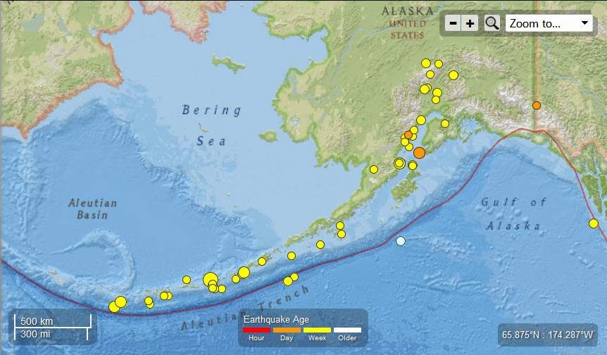
Photo of EQ’s for the last 7 days
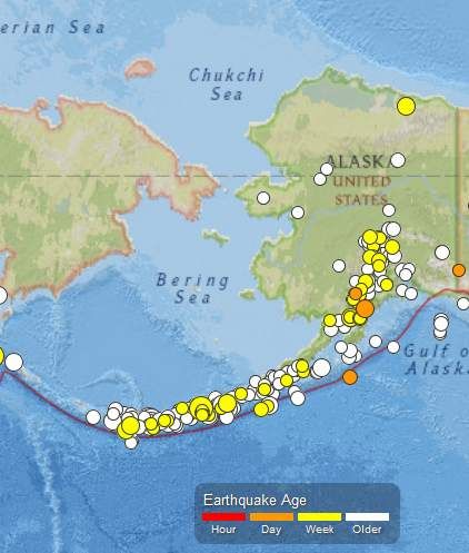
Alaska – 16 EQs May 15-16-17 2013 Photo of EQs last 30 days
….
M3.1 – 60km SSE of Cantwell, Alaska
2013-05-15 06:45:32 UTC

Event Time
- 2013-05-15 06:45:32 UTC
- 2013-05-14 22:45:32 UTC-08:00 at epicenter
- 2013-05-15 01:45:32 UTC-05:00 system time
Location
62.858°N 148.700°W depth=61.2km (38.0mi)
Nearby Cities
- 60km (37mi) SSE of Cantwell, Alaska
- 157km (98mi) NNE of Knik-Fairview, Alaska
- 193km (120mi) NNE of Anchorage, Alaska
- 223km (139mi) SSW of Badger, Alaska
- 756km (470mi) WNW of Whitehorse, Canada
….
M2.8 – 86km E of Old Iliamna, Alaska
2013-05-15 07:19:17 UTC

Event Time
- 2013-05-15 07:19:17 UTC
- 2013-05-14 23:19:17 UTC-08:00 at epicenter
- 2013-05-15 02:19:17 UTC-05:00 system time
Location
59.779°N 153.386°W depth=130.8km (81.3mi)
Nearby Cities
- 86km (53mi) E of Old Iliamna, Alaska
- 249km (155mi) SW of Anchorage, Alaska
- 283km (176mi) SW of Knik-Fairview, Alaska
- 635km (395mi) SSW of Fairbanks, Alaska
- 1017km (632mi) W of Whitehorse, Canada
….
M2.5 – 33km SE of King Salmon, Alaska
2013-05-15 10:09:49 UTC
Event Time
- 2013-05-15 10:09:49 UTC
- 2013-05-15 02:09:49 UTC-08:00 at epicenter
- 2013-05-15 05:09:49 UTC-05:00 system time
Location
58.456°N 156.301°W depth=197.0km (122.4mi)
Nearby Cities
- 33km (21mi) SE of King Salmon, Alaska
- 472km (293mi) SW of Anchorage, Alaska
- 505km (314mi) SW of Knik-Fairview, Alaska
- 841km (523mi) SW of College, Alaska
- 1220km (758mi) W of Whitehorse, Canada
….
M2.5 – 63km ENE of Sand Point, Alaska
2013-05-15 12:04:01 UTC

Event Time
- 2013-05-15 12:04:01 UTC
- 2013-05-15 04:04:01 UTC-08:00 at epicenter
- 2013-05-15 07:04:01 UTC-05:00 system time
Location
55.505°N 159.549°W depth=65.6km (40.8mi)
Nearby Cities
- 63km (39mi) ENE of Sand Point, Alaska
- 849km (528mi) SW of Anchorage, Alaska
- 883km (549mi) SW of Knik-Fairview, Alaska
- 1224km (761mi) SW of College, Alaska
- 1544km (959mi) W of Whitehorse, Canada
….
M2.7 – 18km SE of Redoubt Volcano, Alaska
2013-05-15 12:41:48 UTC

Event Time
- 2013-05-15 12:41:48 UTC
- 2013-05-15 04:41:48 UTC-08:00 at epicenter
- 2013-05-15 07:41:48 UTC-05:00 system time
Location
60.387°N 152.464°W depth=96.7km (60.1mi)
Nearby Cities
- 18km (11mi) SE of Redoubt Volcano, Alaska
- 167km (104mi) WSW of Anchorage, Alaska
- 199km (124mi) SW of Knik-Fairview, Alaska
- 552km (343mi) SSW of Fairbanks, Alaska
- 953km (592mi) W of Whitehorse, Canada
….
M2.7 – 63km SE of Adak, Alaska
2013-05-15 13:26:55 UTC

Event Time
- 2013-05-15 13:26:55 UTC
- 2013-05-15 01:26:55 UTC-12:00 at epicenter
- 2013-05-15 08:26:55 UTC-05:00 system time
Location
51.490°N 175.997°W depth=23.6km (14.7mi)
Nearby Cities
- 63km (39mi) SE of Adak, Alaska
- 1524km (947mi) SSE of Anadyr’, Russia
- 1730km (1075mi) E of Petropavlovsk-Kamchatskiy, Russia
- 1747km (1086mi) E of Yelizovo, Russia
- 2692km (1673mi) W of Whitehorse, Canada
….
M2.7 – 95km N of Kodiak, Alaska
2013-05-15 15:16:55 UTC
Event Time
- 2013-05-15 15:16:55 UTC
- 2013-05-15 07:16:55 UTC-08:00 at epicenter
- 2013-05-15 10:16:55 UTC-05:00 system time
Location
58.648°N 152.537°W depth=4.7km (2.9mi)
Nearby Cities
- 95km (59mi) N of Kodiak, Alaska
- 321km (199mi) SSW of Anchorage, Alaska
- 358km (222mi) SSW of Knik-Fairview, Alaska
- 734km (456mi) SSW of Fairbanks, Alaska
- 1008km (626mi) W of Whitehorse, Canada
….
M2.7 – 112km ESE of Akutan, Alaska
2013-05-15 20:28:28 UTC

Event Time
- 2013-05-15 20:28:28 UTC
- 2013-05-15 09:28:28 UTC-11:00 at epicenter
- 2013-05-15 15:28:28 UTC-05:00 system time
Location
53.833°N 164.138°W depth=41.1km (25.5mi)
Nearby Cities
- 112km (70mi) ESE of Akutan, Alaska
- 1180km (733mi) SW of Anchorage, Alaska
- 1213km (754mi) SW of Knik-Fairview, Alaska
- 1530km (951mi) SW of College, Alaska
- 1894km (1177mi) W of Whitehorse, Canada
….
M3.4 – 209km SSE of Akutan, Alaska
2013-05-15 23:48:07 UTC

Event Time
- 2013-05-15 23:48:07 UTC
- 2013-05-15 12:48:07 UTC-11:00 at epicenter
- 2013-05-15 18:48:07 UTC-05:00 system time
Location
52.401°N 164.556°W depth=25.5km (15.8mi)
Nearby Cities
- 209km (130mi) SSE of Akutan, Alaska
- 1322km (821mi) SW of Anchorage, Alaska
- 1356km (843mi) SW of Knik-Fairview, Alaska
- 1683km (1046mi) SW of College, Alaska
- 2001km (1243mi) W of Juneau, Alaska
….
M2.7 – 45km SSE of Adak, Alaska
2013-05-16 06:10:42 UTC
Event Time
- 2013-05-16 06:10:42 UTC
- 2013-05-15 18:10:42 UTC-12:00 at epicenter
- 2013-05-16 01:10:42 UTC-05:00 system time
Location
51.515°N 176.360°W depth=31.4km (19.5mi)
Nearby Cities
- 45km (28mi) SSE of Adak, Alaska
- 1516km (942mi) SSE of Anadyr’, Russia
- 1705km (1059mi) E of Petropavlovsk-Kamchatskiy, Russia
- 1722km (1070mi) E of Yelizovo, Russia
- 2710km (1684mi) W of Whitehorse, Canada
….
M4.3 – 10km ESE of Nikolski, Alaska
2013-05-16 10:58:56 UTC

Event Time
- 2013-05-16 10:58:56 UTC
- 2013-05-16 01:58:56 UTC-09:00 at epicenter
- 2013-05-16 05:58:56 UTC-05:00 system time
Location
52.890°N 168.728°W depth=45.8km (28.5mi)
Nearby Cities
- 10km (6mi) ESE of Nikolski, Alaska
- 1462km (908mi) WSW of Anchorage, Alaska
- 1493km (928mi) WSW of Knik-Fairview, Alaska
- 1535km (954mi) SE of Anadyr’, Russia
- 2203km (1369mi) W of Whitehorse, Canada
….
M2.5 – 17km WNW of Willow, Alaska
2013-05-16 21:48:30 UTC
Event Time
- 2013-05-16 21:48:30 UTC
- 2013-05-16 13:48:30 UTC-08:00 at epicenter
- 2013-05-16 16:48:30 UTC-05:00 system time
Location
61.780°N 150.364°W depth=8.5km (5.3mi)
Nearby Cities
- 17km (11mi) WNW of Willow, Alaska
- 50km (31mi) NW of Knik-Fairview, Alaska
- 67km (42mi) NNW of Anchorage, Alaska
- 365km (227mi) SSW of Fairbanks, Alaska
- 828km (514mi) WNW of Whitehorse, Canada
….
M4.3 – 44km SW of Homer, Alaska
2013-05-17 05:24:55 UTC
Event Time
- 2013-05-17 05:24:55 UTC
- 2013-05-16 21:24:55 UTC-08:00 at epicenter
- 2013-05-17 00:24:55 UTC-05:00 system time
Location
59.309°N 151.993°W depth=54.4km (33.8mi)
Nearby Cities
- 44km (27mi) SW of Homer, Alaska
- 242km (150mi) SSW of Anchorage, Alaska
- 278km (173mi) SSW of Knik-Fairview, Alaska
- 654km (406mi) SSW of Badger, Alaska
- 954km (593mi) W of Whitehorse, Canada
….
Contributed by Alaska Earthquake Information Center
Instrumental Intensity

….
M3.5 – 176km SE of Chirikof Island, Alaska
2013-05-17 15:43:24 UTC

Event Time
- 2013-05-17 15:43:24 UTC
- 2013-05-17 05:43:24 UTC-10:00 at epicenter
- 2013-05-17 10:43:24 UTC-05:00 system time
Location
54.668°N 153.735°W depth=9.8km (6.1mi)
Nearby Cities
- 176km (109mi) SE of Chirikof Island, Alaska
- 763km (474mi) SSW of Anchorage, Alaska
- 799km (496mi) SSW of Knik-Fairview, Alaska
- 1180km (733mi) SSW of Badger, Alaska
- 1251km (777mi) W of Juneau, Alaska
….
M2.5 – 39km SSW of Redoubt Volcano, Alaska
2013-05-17 23:58:06 UTC
Event Time
- 2013-05-17 23:58:06 UTC
- 2013-05-17 15:58:06 UTC-08:00 at epicenter
- 2013-05-17 18:58:06 UTC-05:00 system time
Location
60.162°N 153.031°W depth=121.9km (75.7mi)
Nearby Cities
- 39km (24mi) SSW of Redoubt Volcano, Alaska
- 207km (129mi) WSW of Anchorage, Alaska
- 239km (149mi) SW of Knik-Fairview, Alaska
- 588km (365mi) SSW of Fairbanks, Alaska
- 988km (614mi) W of Whitehorse, Canada
….
M2.6 – 186km NNE of Cape Yakataga, Alaska
2013-05-18 01:59:14 UTC

Event Time
- 2013-05-18 01:59:14 UTC
- 2013-05-17 18:59:14 UTC-07:00 at epicenter
- 2013-05-17 20:59:14 UTC-05:00 system time
Location
61.504°N 140.689°W depth=0.1km (0.1mi)
Nearby Cities
- 186km (116mi) NNE of Cape Yakataga, Alaska
- 316km (196mi) WNW of Whitehorse, Canada
- 474km (295mi) E of Knik-Fairview, Alaska
- 493km (306mi) E of Anchorage, Alaska
- 499km (310mi) NW of Juneau, Alaska
….
Tectonic Summary
Seismotectonics of Alaska
The Aleutian arc extends approximately 3,000 km from the Gulf of Alaska in the east to the Kamchatka Peninsula in the west. It marks the region where the Pacific plate subducts into the mantle beneath the North America plate. This subduction is responsible for the generation of the Aleutian Islands and the deep offshore Aleutian Trench.
The curvature of the arc results in a westward transition of relative plate motion from trench-normal (i.e., compressional) in the east to trench-parallel (i.e., translational) in the west, accompanied by westward variations in seismic activity, volcanism, and overriding plate composition. The Aleutian arc is generally divided into three regions: the western, central, and eastern Aleutians. Relative to a fixed North America plate, the Pacific plate is moving northwest at a rate that increases from roughly 60 mm/yr at the arc’s eastern edge to 76 mm/yr near its western terminus. The eastern Aleutian arc extends from the Alaskan Peninsula in the east to the Fox Islands in the west. Motion along this section of the arc is characterized by arc-perpendicular convergence and Pacific plate subduction beneath thick continental lithosphere. This region exhibits intense volcanic activity and has a history of megathrust earthquakes.
The central Aleutian arc extends from the Andreanof Islands in the east to the Rat Islands in the west. Here, motion is characterized by westward-increasing oblique convergence and Pacific plate subduction beneath thin oceanic lithosphere. Along this portion of the arc, the Wadati-Benioff zone is well defined to depths of approximately 200 km. Despite the obliquity of convergence, active volcanism and megathrust earthquakes are also present along this margin.
The western Aleutians, stretching from the western end of the Rat Islands in the east to the Commander Islands, Russia, in the west, is tectonically different from the central and eastern portions of the arc. The increasing component of transform motion between the Pacific and North America plates is evidenced by diminishing active volcanism; the last active volcano is located on Buldir Island, in the far western portion of the Rat Island chain. Additionally, this portion of the subduction zone has not hosted large earthquakes or megathrust events in recorded history. Instead, the largest earthquakes in this region are generally shallow, predominantly strike-slip events with magnitudes between M5-6. Deeper earthquakes do occur, albeit rather scarcely and with small magnitudes (M<4), down to approximately 50 km.
Most of the seismicity along the Aleutian arc results from thrust faulting that occurs along the interface between the Pacific and North America plates, extending from near the base of the trench to depths of 40 to 60 km. Slip along this interface is responsible for generating devastating earthquakes. Deformation also occurs within the subducting slab in the form of intermediate-depth earthquakes that can reach depths of 250 km. Normal faulting events occur in the outer rise region of the Aleutian arc resulting from the bending of the oceanic Pacific plate as it enters the Aleutian trench. Additionally, deformation of the overriding North America plate generates shallow crustal earthquakes.
The Aleutian arc is a seismically active region, evidenced by the many moderate to large earthquakes occurring each year. Since 1900, this region has hosted twelve large earthquakes (M>7.5) including the May 7, 1986 M8.0 Andreanof Islands, the June 10, 1996 M7.9 Andreanof Islands, and the November 17, 2003 M7.8 Rat Islands earthquakes. Six of these great earthquakes (M8.3 or larger) have occurred along the Aleutian arc that together have ruptured almost the entire shallow megathrust contact. The first of these major earthquakes occurred on August 17, 1906 near the island of Amchitka (M8.3) in the western Aleutian arc. However, unlike the other megathrust earthquakes along the arc, this event is thought to have been an intraplate event occurring in the shallow slab beneath the subduction zone interface.
The first megathrust event along the arc during the 20th century was the November 10, 1938 M8.6 Shumagin Island earthquake. This event ruptured an approximately 300 km long stretch of the arc from the southern end of Kodiak Island to the northern end of the Shumagin Islands and generated a small tsunami that was recorded as far south as Hawaii.
….
Alaska – 5 Earthquakes , 4.5 to 2.6 Magnitude May 14th, 2013 : Total of 126 EQ’s in the last 27 days
….
Alaska – 5.7 Magnitude Earthquake, 46km W of Amukta Island. Total of 122 EQ’s in 27 days
….
Alaska - 2 Earthquakes , 4.8 to 4.2 Magnitude May 10th, 2013 : Total of 121 EQ’s in the last 26 days
….
Alaska - 16 Earthquakes Ranging from 4.5 to 2.5 Magnitude in the last 3 days May 7th – 9th, 2013 : Total of 119 EQ’s in the last 25 days
…
Alaska - 8 Earthquakes Ranging From 3.6 to 2.6 Magnitude May 3rd, 4th and 5th 2013 : Total of 103 EQ’s in the last 22 days
…
Alaska - 6 Earthquakes Ranging From 4.5 to 2.5 Magnitude May 2nd, 2013 : Total of 95 EQ’s in the last 19 days
…
Alaska - 6 Earthquakes Ranging From 3.2 to 2.5 Magnitude : Total of 89 EQ’s in the last 18 days
…
Alaska – 8 EQ’s ranging from 3.2 to2.6 magnitude April 30th, 2013 : Total of 83 Earthquakes in the last 17 days
…
Alaska – Nineteen Earthquakes Ranging From 5.1 to 2.5 Magnitude April 22nd and 23rd , 2013. A Total of 75 EQ’s in the last 10 days
…
Alaska – Three Earthquakes Ranging From 5.7 to 2.5 Magnitude April 21st , 2013. A Total of 56 EQ’s in the last 8 days
…
Alaska : Earthquake swarm. 12 earthquakes within the range of 2.5 to 4.5 Magnitude registered April 13th and 14th, 2013
…
Earth Watch Report - Earthquakes
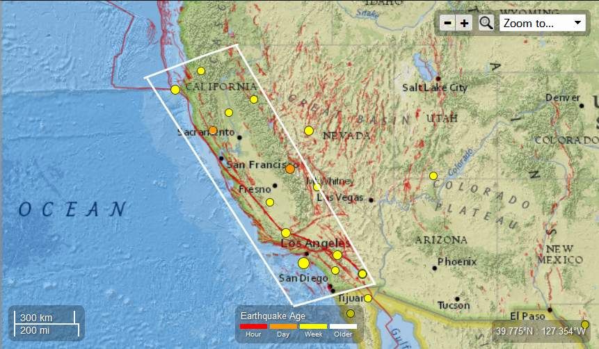
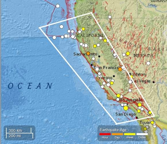
California – 12 EQs May 15-16-17 2013 photo of EQs in the last 30 days
….
M3.0 – 6km NW of The Geysers, California
2013-05-15 06:11:55 UTC

Event Time
- 2013-05-15 06:11:55 UTC
- 2013-05-14 23:11:55 UTC-07:00 at epicenter
- 2013-05-15 01:11:55 UTC-05:00 system time
Location
38.819°N 122.804°W depth=4.0km (2.5mi)
Nearby Cities
- 6km (4mi) NW of The Geysers, California
- 21km (13mi) SW of Clearlake, California
- 23km (14mi) NNE of Healdsburg, California
- 30km (19mi) N of Windsor, California
- 116km (72mi) WNW of Sacramento, California
….
M3.1 – 7km NNE of Cabazon, California
2013-05-15 16:20:05 UTC

Event Time
- 2013-05-15 16:20:05 UTC
- 2013-05-15 09:20:05 UTC-07:00 at epicenter
- 2013-05-15 11:20:05 UTC-05:00 system time
Location
33.980°N 116.767°W depth=17.9km (11.1mi)
Nearby Cities
- 7km (4mi) NNE of Cabazon, California
- 11km (7mi) ENE of Banning, California
- 20km (12mi) ENE of Beaumont, California
- 24km (15mi) W of Desert Hot Springs, California
- 438km (272mi) W of Phoenix, Arizona
….
M4.0 – 10km S of Rancho Palos Verdes, California
2013-05-15 20:00:06 UTC

Event Time
- 2013-05-15 20:00:06 UTC
- 2013-05-15 13:00:06 UTC-07:00 at epicenter
- 2013-05-15 15:00:06 UTC-05:00 system time
Location
33.658°N 118.372°W depth=1.2km (0.7mi)
Nearby Cities
- 10km (6mi) S of Rancho Palos Verdes, California
- 12km (7mi) SW of San Pedro, California
- 16km (10mi) SSW of Lomita, California
- 16km (10mi) S of Palos Verdes Estates, California
- 586km (364mi) W of Phoenix, Arizona
….
Instrumental Intensity

….
M2.6 – 17km E of Willows, California
2013-05-15 22:15:50 UTC

Event Time
- 2013-05-15 22:15:50 UTC
- 2013-05-15 15:15:50 UTC-07:00 at epicenter
- 2013-05-15 17:15:50 UTC-05:00 system time
Location
39.508°N 121.988°W depth=22.6km (14.0mi)
Nearby Cities
- 17km (11mi) E of Willows, California
- 27km (17mi) SSW of Chico, California
- 37km (23mi) W of Oroville, California
- 42km (26mi) SW of Paradise, California
- 111km (69mi) NNW of Sacramento, California
….
M2.9 – 8km SSE of Aguanga, California
2013-05-16 00:30:33 UTC
Event Time
- 2013-05-16 00:30:33 UTC
- 2013-05-15 17:30:33 UTC-07:00 at epicenter
- 2013-05-15 19:30:33 UTC-05:00 system time
Location
33.373°N 116.841°W depth=6.6km (4.1mi)
Nearby Cities
- 8km (5mi) SSE of Aguanga, California
- 31km (19mi) ESE of Temecula, California
- 36km (22mi) NE of Escondido, California
- 36km (22mi) N of Ramona, California
- 443km (275mi) W of Phoenix, Arizona
….
M3.2 – 7km W of Pine Mountain Club, California
2013-05-16 10:04:58 UTC
Event Time
- 2013-05-16 10:04:58 UTC
- 2013-05-16 03:04:58 UTC-07:00 at epicenter
- 2013-05-16 05:04:58 UTC-05:00 system time
Location
34.858°N 119.239°W depth=12.7km (7.9mi)
Nearby Cities
- 7km (4mi) W of Pine Mountain Club, California
- 53km (33mi) SSW of Lamont, California
- 54km (34mi) SW of Arvin, California
- 57km (35mi) NNE of Carpinteria, California
- 459km (285mi) SSE of Sacramento, California
….
M2.6 – 8km NW of Kettleman City, California
2013-05-17 02:39:50 UTC
Event Time
- 2013-05-17 02:39:50 UTC
- 2013-05-16 19:39:50 UTC-07:00 at epicenter
- 2013-05-16 21:39:50 UTC-05:00 system time
Location
36.068°N 120.012°W depth=62.0km (38.5mi)
Nearby Cities
- 8km (5mi) NW of Kettleman City, California
- 12km (7mi) NE of Avenal, California
- 32km (20mi) ESE of Coalinga, California
- 33km (21mi) SW of Lemoore, California
- 308km (191mi) SSE of Sacramento, California
….
M3.5 – 5km SW of Niland, California
2013-05-17 03:07:52 UTC
Event Time
- 2013-05-17 03:07:52 UTC
- 2013-05-16 20:07:52 UTC-07:00 at epicenter
- 2013-05-16 22:07:52 UTC-05:00 system time
Location
33.203°N 115.550°W depth=1.9km (1.2mi)
Nearby Cities
- 5km (3mi) SW of Niland, California
- 24km (15mi) N of Brawley, California
- 39km (24mi) N of Imperial, California
- 45km (28mi) N of El Centro, California
- 324km (201mi) W of Phoenix, Arizona
….
Instrumental Intensity

….
M3.1 – 4km SW of Niland, California
2013-05-17 04:38:13 UTC
Event Time
- 2013-05-17 04:38:13 UTC
- 2013-05-16 21:38:13 UTC-07:00 at epicenter
- 2013-05-16 23:38:13 UTC-05:00 system time
Location
33.212°N 115.552°W depth=1.8km (1.1mi)
Nearby Cities
- 4km (2mi) SW of Niland, California
- 26km (16mi) N of Brawley, California
- 40km (25mi) N of Imperial, California
- 46km (29mi) N of El Centro, California
- 324km (201mi) W of Phoenix, Arizona
….
M2.7 – 4km SW of Niland, California
2013-05-17 05:18:29 UTC
Event Time
- 2013-05-17 05:18:29 UTC
- 2013-05-16 22:18:29 UTC-07:00 at epicenter
- 2013-05-17 00:18:29 UTC-05:00 system time
Location
33.208°N 115.546°W depth=0.0km (0.0mi)
Nearby Cities
- 4km (2mi) SW of Niland, California
- 25km (16mi) N of Brawley, California
- 40km (25mi) N of Imperial, California
- 46km (29mi) N of El Centro, California
- 324km (201mi) W of Phoenix, Arizona
….
M3.0 – 30km S of Mammoth Lakes, California
2013-05-17 18:53:20 UTC
Event Time
- 2013-05-17 18:53:20 UTC
- 2013-05-17 11:53:20 UTC-07:00 at epicenter
- 2013-05-17 13:53:20 UTC-05:00 system time
Location
37.378°N 119.038°W depth=10.8km (6.7mi)
Nearby Cities
- 30km (19mi) S of Mammoth Lakes, California
- 85km (53mi) NE of Clovis, California
- 87km (54mi) NNE of Sanger, California
- 94km (58mi) NNE of Reedley, California
- 208km (129mi) SSE of Carson City, Nevada
….
M2.6 – 4km NW of The Geysers, California
2013-05-18 00:11:00 UTC
Event Time
- 2013-05-18 00:11:00 UTC
- 2013-05-17 17:11:00 UTC-07:00 at epicenter
- 2013-05-17 19:11:00 UTC-05:00 system time
Location
38.806°N 122.791°W depth=1.3km (0.8mi)
Nearby Cities
- 4km (2mi) NW of The Geysers, California
- 22km (14mi) SW of Clearlake, California
- 22km (14mi) NNE of Healdsburg, California
- 28km (17mi) N of Windsor, California
- 115km (71mi) WNW of Sacramento, California
….
California – 2 Earthquakes Ranging From 2.6 to 2.5 Magnitude May 13th – 14th 2013 : Total of 44 EQ’s in the last 18 days.
….
California – 5 Earthquakes Ranging From 3.5 to 2.5 Magnitude May 10th 2013 : Total of 42 EQ’s in the last 15 days.
….
California - 12 Earthquakes Ranging From 3.6 to 2.5 Magnitude May 5th to 9th , 2013 : Total of 37 EQ’s in the last 14 days.
…
California - 5 Earthquakes Ranging From 3.2 to 2.5 Magnitude May 3rd , 2013 : Total of 25 EQ’s in the last six days. None were registered for May 4th, 2013
…
California - 3 Low Intensity Earthquakes Ranging From 2.5 to 2.8 Magnitude May 2nd , 2013 : Total of 20 EQ’s in the last four days
…
California - 5 Earthquakes Ranging from 3.9 to 2.5 Magnitude May 1st , 2013. : Total of 17 EQ’s in the last three days
…
California – 10 Earthquakes Ranging Between 2.5 and 3.0 Registered April 29th,2013
…
California 2 Earthquakes 2.5 and a 3.0 Magnitude : Total of 12 EQ’s in the last 2 days
…
Earth Watch Report - Earthquakes
….
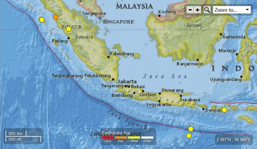
M4.8 – 167km WSW of Sibolga, Indonesia
2013-05-15 10:22:17 UTC

Event Time
- 2013-05-15 10:22:17 UTC
- 2013-05-15 17:22:17 UTC+07:00 at epicenter
- 2013-05-15 05:22:17 UTC-05:00 system time
Location
1.059°N 97.440°E depth=41.7km (25.9mi)
Nearby Cities
- 167km (104mi) WSW of Sibolga, Indonesia
- 196km (122mi) SE of Sinabang, Indonesia
- 206km (128mi) W of Padangsidempuan, Indonesia
- 254km (158mi) SSW of Kabanjahe, Indonesia
- 525km (326mi) WSW of Kuala Lumpur, Malaysia
….
M4.6 – 255km S of Sidorukun, Indonesia
2013-05-15 14:24:00 UTC

Event Time
- 2013-05-15 14:24:00 UTC
- 2013-05-15 22:24:00 UTC+08:00 at epicenter
- 2013-05-15 09:24:00 UTC-05:00 system time
Location
10.880°S 113.842°E depth=10.0km (6.2mi)
Nearby Cities
- 255km (158mi) S of Sidorukun, Indonesia
- 275km (171mi) S of Muncar, Indonesia
- 277km (172mi) S of Gambiran Satu, Indonesia
- 278km (173mi) S of Srono, Indonesia
- 927km (576mi) SE of Jakarta, Indonesia
….
M4.7 – 19km ENE of Bonjol, Indonesia
2013-05-16 01:11:28 UTC

Event Time
- 2013-05-16 01:11:28 UTC
- 2013-05-16 08:11:28 UTC+07:00 at epicenter
- 2013-05-15 20:11:28 UTC-05:00 system time
Location
0.041°N 100.393°E depth=157.2km (97.7mi)
Nearby Cities
- 19km (12mi) ENE of Bonjol, Indonesia
- 38km (24mi) N of Bukittinggi, Indonesia
- 39km (24mi) NW of Payakumbuh, Indonesia
- 79km (49mi) NNE of Pariaman, Indonesia
- 371km (231mi) SSW of Kuala Lumpur, Malaysia
….
M4.4 – South of Java, Indonesia
2013-05-16 16:26:55 UTC
Event Time
- 2013-05-16 16:26:55 UTC
- 2013-05-17 00:26:55 UTC+08:00 at epicenter
- 2013-05-16 11:26:55 UTC-05:00 system time
Location
11.601°S 113.644°E depth=4.9km (3.1mi)
Nearby Cities
- 337km (209mi) S of Sidorukun, Indonesia
- 358km (222mi) SSW of Muncar, Indonesia
- 358km (222mi) S of Gambiran Satu, Indonesia
- 359km (223mi) SSW of Kuta, Indonesia
- 955km (593mi) SE of Jakarta, Indonesia
….
M4.2 – 35km W of Padangsidempuan, Indonesia
2013-05-17 21:27:56 UTC
Event Time
- 2013-05-17 21:27:56 UTC
- 2013-05-18 04:27:56 UTC+07:00 at epicenter
- 2013-05-17 16:27:56 UTC-05:00 system time
Location
1.359°N 98.946°E depth=115.8km (72.0mi)
Nearby Cities
- 35km (22mi) W of Padangsidempuan, Indonesia
- 46km (29mi) SSE of Sibolga, Indonesia
- 117km (73mi) SW of Bandar, Indonesia
- 128km (80mi) SW of Rantauprapat, Indonesia
- 363km (226mi) WSW of Kuala Lumpur, Malaysia
….
Indonesia – 8 Earthquakes 5.7 to 4.2 Magnitude May 12th -14th , 2013. Total of 25 EQ’s in the last 12 days ….
….
Indonesia – 2 Earthquakes 5.0 to 4.4 Magnitude May 10th and 11th , 2013. Total of 17 EQ’s in the last 9 days .
….
Indonesia - 6 Earthquakes Ranging From 5.0 to 4.4 Magnitude May 8th to 9th , 2013. Total of 15 EQ’s in the last 7 days
….
Indonesia- 6 Earthquakes Ranging From 5.0 to 4.5 Magnitude May 3rd and 4th , 2013. Total of 9 EQ’s in the last 3 days
….
Indonesia- 3 Earthquakes Ranging From 5.3 to 4.3 Magnitude May 2nd , 2013
….
Published on May 18, 2013
The CELESTIAL Convergence | http://thecelestialconvergence.blogsp…
May 18, 2013 – CHILE – Chilean Navy discovers more than 600 dead animals in Punta de Choros, a small fishing town north of La Serena.
The bodies of sea lions, cormorants and penguins littered a seven mile stretch of beach in Punta de Choros, northern Chile on Sunday. The crime scene is in close proximity to the Humboldt Penguin Nature Reserve.
Two days prior the Movement in Defense of the Environment (MODEMA) reported a band of ten fishing boats off the coastline of Punta de Choros. MODEMA and other environmental groups accused the boats of blast fishing — using explosives to catch mass quantities of fish.
Sernapesca, Chile’s National Fishing Service, investigated the scene and determined that all the animals were killed by the same incident. Autopsies report animales with fractured skulls, missing rib cages and multiple abrasions.
Local authorities promptly called in the Investigative Police’s (PDI) Environmental Crime Brigade for further investigation. Microbiological and chemical analysis tests are currently being run to determine if blast fishing is the cause of death.
In Chile, blast fishing is illegal. Companies caught fishing in this manner face prison time and fines. The monetary amount depends on the damage to the ecosystem. However, causing the death of penguins during commercial activities is a jailable offense. Officials from Sernapesca told The Santiago Times that the combined offenses amount to a “serious crime.”
“This situation is quite complicated because of the crime scene’s location near the penguin reserve,” Cristián Felmer, an environmental expert, stated to the press. “This is one of the most important environmental incidents we’ve had in recent memory.”
This isn’t the first environmental calamity at Punta de Choros. In April of last year, 350 Guayano cormorants washed up on the beach. The next month, Sernapesca reported the deaths of more than 80 sea lions.
In light of the most recent crime, the international marine conservation group Oceana is pushing to have Punta de Choros made a Marine and Coastal Protected Area (AMCP). The proposal would limit human activity along the more than 175-mile coastline to eco-friendly tourism.
“While there are two marine reserves in the area, this ecosystem is much larger and has little protection from threats such as those that apparently killed all these birds,” Alex Muñoz, executive director of Oceana, told press.
Oceana filed a joint proposal with scientists from Universidad Católica and the Center for Advanced Studies in Dry Areas (CEAZA) to make Punta de Choros a AMCP in 2010. The proposal came amid plans to build a thermoelectric power plant in the area. The highly controversial plan was scrapped after generating a wave of protests.
Punta de Choros is a small fishing village of 320 people. It is home to the largest population of Humboldt penguins in the world. The site attracts thousands of tourists annually.
The CELESTIAL Convergence | http://thecelestialconvergence.blogsp…
Related articles
- Penguins and sea lions found dead on Chilean shore (sott.net)
- Chile investigates alleged case of blast-fishing close to a major Humboldt rookery (en.mercopress.com)
- Chile: hundreds of dead animals washed up on shore (sott.net)
- Hundreds of dead animals wash up on Chile’s shores (utsandiego.com)
- Hundreds of dead animals wash up on Chile’s shores (foxnews.com)
- Hundreds of dead animals wash up on Chile’s shores (seattletimes.com)
- Hundreds of Dead Animals Wash up on Chile’s Shores (abcnews.go.com)
- Hundreds of dead animals washing up on Chilean shores (ctvnews.ca)
Earth Watch Report - Earthquakes
3 EQs May 18t, 2013
Registered Earthquakes last 30 days
….
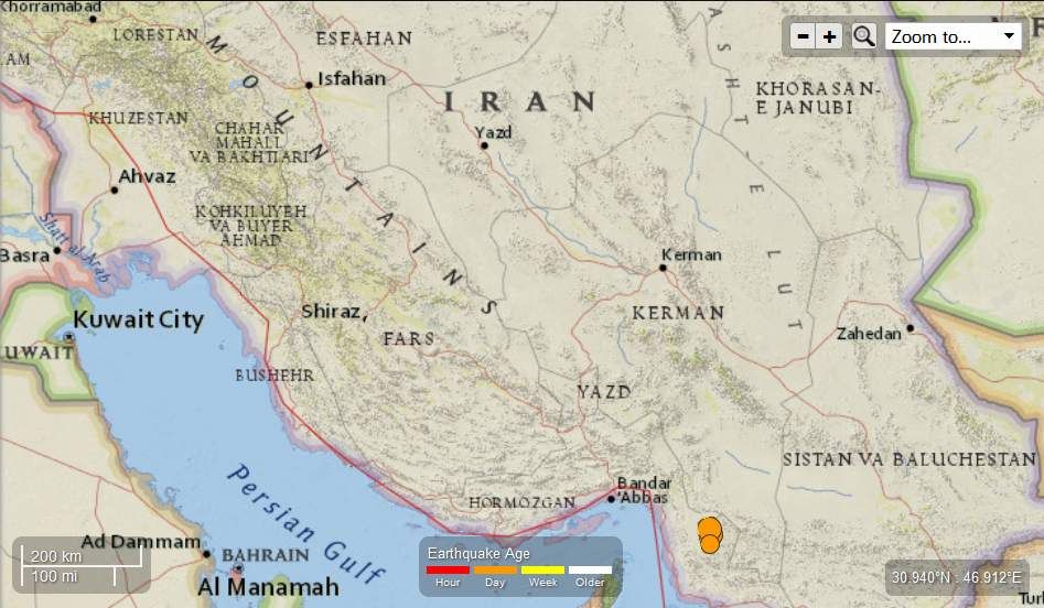
M5.6 – 88km SE of Minab, Iran
2013-05-18 10:03:18 UTC

Event Time
- 2013-05-18 10:03:18 UTC
- 2013-05-18 14:33:18 UTC+04:30 at epicenter
- 2013-05-18 05:03:18 UTC-05:00 system time
Location
26.688°N 57.811°E depth=9.9km (6.2mi)
Nearby Cities
- 88km (55mi) SE of Minab, Iran
- 155km (96mi) E of Qeshm, Iran
- 161km (100mi) ESE of Bandar ‘Abbas, Iran
- 165km (103mi) ENE of Khasab, Oman
- 349km (217mi) NNW of Muscat, Oman
….

….
M5.5 – 81km ESE of Minab, Iran
2013-05-18 10:57:50 UTC
Event Time
- 2013-05-18 10:57:50 UTC
- 2013-05-18 15:27:50 UTC+04:30 at epicenter
- 2013-05-18 05:57:50 UTC-05:00 system time
Location
26.768°N 57.778°E depth=9.7km (6.0mi)
Nearby Cities
- 81km (50mi) ESE of Minab, Iran
- 151km (94mi) E of Qeshm, Iran
- 155km (96mi) ESE of Bandar ‘Abbas, Iran
- 165km (103mi) ENE of Khasab, Oman
- 358km (222mi) NNW of Muscat, Oman
….

….
M4.4 – 94km SE of Minab, Iran
2013-05-18 12:09:42 UTC
Event Time
- 2013-05-18 12:09:42 UTC
- 2013-05-18 16:39:42 UTC+04:30 at epicenter
- 2013-05-18 07:09:42 UTC-05:00 system time
Location
26.570°N 57.779°E depth=10.0km (6.2mi)
Nearby Cities
- 94km (58mi) SE of Minab, Iran
- 155km (96mi) ESE of Qeshm, Iran
- 158km (98mi) ENE of Khasab, Oman
- 163km (101mi) ESE of Bandar ‘Abbas, Iran
- 337km (209mi) NNW of Muscat, Oman
….
….
Related articles
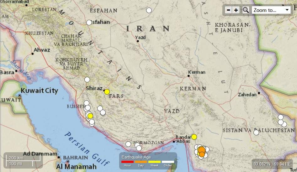
- Iran – 6.0 Magnitude Earthquake with 9 aftershocks and counting Ranging From 5.3 to 4.4 Magnitude May 10th 2013. Total of 52 in the last 28 days (familysurvivalprotocol.com)
- Iran – Seismic Activity continues with 5 more registered quakes Ranging From 5.4 to 4.1 Magnitude May 12th 2013. Total of 57 in the last 29 days (familysurvivalprotocol.com)
- Earthquake in Southern Iran: Tremors felt in Dubai (disaster-report.com)
- Iran – Seismic Activity continues with 13 more registered quakes Ranging From 5.6 to 4.3 Magnitude May 10th 2013. Total of 52 in the last 28 days (familysurvivalprotocol.com)
- USGS: Earthquake Magnitude 6.2 – ESE of Minab, Iran (sott.net)
- USGS: Earthquake Magnitude 6.0 – ESE of Minab, Iran (sott.net)
- Magnitude 6.0 89km ESE of Minab. Iran {F} 11-May-13 (quakewatch.wordpress.com)
- Iran – 3 Earthquakes Ranging From 5.1 to 4.1 Magnitude May 01, 2013 . Total of 35 EQ’s in the last 21 days (familysurvivalprotocol.com)
- 5.7 Magnitude Earthquake – 107km E of Khash, Iran (familysurvivalprotocol.com)
Earth Watch Report - Epidemic Hazards

")
Reuters
Riyadh: A new case of deadly coronavirus has been detected in Saudi Arabia where 15 people have already died after contracting it, the Health Ministry announced today on its Internet Web site. “One new case of novel coronavirus was recorded in the eastern region” where most of the kingdom’s cases have been registered, the Ministry said, which had this week created a special web page dedicated to the outbreak.
….
| 19 | 19.05.2013 | Epidemic Hazard | Saudi Arabia | Eastern Province, Al-hasa |
….
Epidemic Hazard in Saudi Arabia on Thursday, 02 May, 2013 at 07:12 (07:12 AM) UTC.
| Updated: | Sunday, 19 May, 2013 at 04:49 UTC |
| Description | |
| A new case of the deadly coronavirus has been detected in the Kingdom, where 15 people have already died after contracting it, the Health Ministry announced on Saturday on its website. One new case of the novel coronavirus has been recorded in the Eastern Province, where most of the Kingdom’s cases have been registered, said the Ministry, which this week created a special web page dedicated to the outbreak. “One case of coronavirus has been recorded in the Eastern Region, and he is now under the medical healthcare receiving the proper treatment,” the web page in English reported. The latest case takes to 31 the number of officially recorded cases of the virus in Saudi Arabia since September. Fifteen of those have died. | |
….
New case of coronavirus in EP: Health Ministry
Last updated: Saturday, May 18, 2013 8:10 PM
RIYADH — A new case of the deadly coronavirus has been detected in the Kingdom, where 15 people have already died after contracting it, the Health Ministry announced on Saturday on its website.
One new case of the novel coronavirus has been recorded in the Eastern Province, where most of the Kingdom’s cases have been registered, said the Ministry, which this week created a special web page dedicated to the outbreak.
“One case of coronavirus has been recorded in the Eastern Region, and he is now under the medical healthcare receiving the proper treatment,” the web page in English reported.
The latest case takes to 31 the number of officially recorded cases of the virus in Saudi Arabia since September. Fifteen of those have died.
Earth Watch Report - Biological Hazards

….
| 18.05.2013 | Biological Hazard | China | Multiple areas, [Provinces of Anhui, Jiangsu, Zhejiang, Hangzhou, Hunan, Jiangxi, Fujian and Capital City region] |
….
Biological Hazard in China on Sunday, 31 March, 2013 at 13:02 (01:02 PM) UTC.
| Updated: | Saturday, 18 May, 2013 at 05:07 UTC |
| Description | |
| Four more people have died from a new strain of bird flu in China, bringing the death toll from the H7N9 virus to 36 from 131 confirmed cases, the World Health Organisation (WHO) has said. The United Nations health agency said a written statement on Friday that the four deaths were from cases that had already been identified in laboratories. It said here had been no new cases of infection with H7N9 Since May 8. The WHO reiterated that there was no evidence that the new strain of bird flu, which was first detected in patients in China in March, was passing easily from human to human. If such a feature emerged it could spark a pandemic. But it said: “Until the source of infection has been identified and controlled, it is expected that there will be further cases of human infection with the virus.” The WHO said that Chinese health authorities had continued with enhanced surveillance, epidemiological investigations, close contact tracing, clinical management, laboratory testing and sharing of samples as well as prevention and control measures. The number of new cases has dwindled in some provinces and operations. | |
….
….
‘

Photo: EPA
Four more people in China have died from a new strain of bird flu, bringing the number of deaths from the mysterious H7N9 virus to 31, with the number of infections rising by two to 129, according to Chinese health authorities.
Among the deaths, two occurred in the eastern province of Jiangsu; one was from eastern Zhejiang; while another was from central Anhui, based on a Reuters analysis of the data provided by Chinese health authorities on Monday.
This 1985 CNN Special Report
on electromagnetic weapons, that
could make any of the Geneva Peace
Accords then on the table meaningless
takes us back to a simpler time, when
CNN actually reported the news.
http://www.wunderground.com/news/solar-flares-sun-earth-20130515
http://www.accuweather.com/en/weather-news/anchorage-rare-may-snow-could-1/12489070
http://www.weather.com/news/tornado-central/severe-weather-tracker-page
http://www.wnd.com/2013/05/worst-case-emp-scenario-half-in-u-s-dead/